The White Rim Sandstone is one of the most recognizable rock layers found in the canyon country surrounding Moab. It holds up its eponymous bench (the White Rim) below the Island in the Sky mesa in Canyonlands National Park. Like a number of other rock layers found near Moab, including the Entrada and Navajo sandstones, it formed in a sand dune (erg) environment. However, two aspects of the White Rim Sandstone set it apart from the other eolian (wind-deposited) layers: its off-white color, and the fact one can discern the edge of its ancient sand dune environment.
Rock layers (formations) like the White Rim Sandstone are classified according to set of standards that geologists apply when naming and describing rock units. Formations are the fundamental units within that classification system (see the February 2018 Geology Happenings column in the article archive at https://www.moabhappenings.com/Geology.htm to learn more). Related formations are sometimes put together as part of a larger group. The White Rim Sandstone belongs to the Cutler Group, a package of sediments that were shed off the Ancestral Rocky Mountains in western Colorado, northeast of Moab, during the Permian period, between about 290 and 275 million years ago.
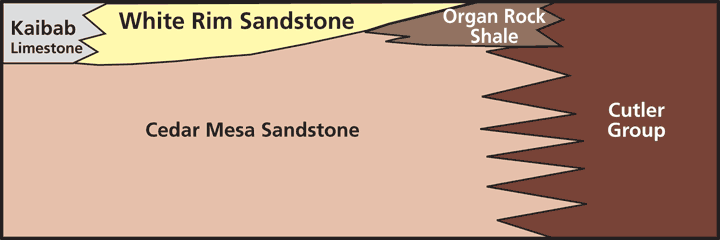
The rock types in the Cutler Group vary both vertically and laterally, especially further away from the ancient mountain range, and these variations are designated as separate formations. In the Canyonlands area, the Cutler contains the Cedar Mesa Sandstone, the Organ Rock Formation (shale) and the White Rim Sandstone, and each were deposited in slightly different areas and in slightly different environments. North of Moab, the Cutler Group is not broken into separate formations and is frequently just called the “Cutler undivided.” Fisher Towers near the river road (Highway 128) north of Moab is in the undivided Cutler and is part of the thick sequence of red sediments that were deposited by rivers that flowed from the ancient mountains.
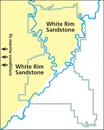 |
| Map showing the extent of the White Rim Sandstone in Canyonlands National Park. Park boundaries and location of modern rivers are for reference only. |
The interrelationships between the White Rim and other formations in the Cutler Group are complex, resulting from different types of sediment being deposited in slightly different environments. Both the Cedar Mesa and White Rim sandstones were deposited in dunefields. The Cedar Mesa erg lay southeast of the area where the White Rim erg was deposited a short time later, at approximately 275 million years ago. Rivers deposited the fine-grain sediments of the Organ Rock Formation in ancient channels and floodplains in the Canyonlands area and further south during a wetter period between the two periods of eolian deposition.
The eastern boundary of the White Rim dunefield was located approximately where the Colorado River is today. The White Rim Sandstone progressively thins to the east where it pinches out near the Colorado River and below Dead Horse Point. This pinch out represents the very edge of the sands at the margin of the ancient dunes.
Near the Green River, the White Rim Sandstone is approximately 250 feet thick. It is thicker west of Canyonlands where it reaches approximately 800 feet thick in the subsurface below Hanksville. In Capitol Reef National Park, where the layer is exposed in some of the deepest canyons, the unit shows evidence of coastal dunes that were becoming inundated by marine waters.
The White Rim bench below the Island in the Sky results from the sandstone that defines it also being harder and more resistant to erosion that the rocks layers above and below. The softer Organ Rock Formation below is protected from erosion where the White Rim Sandstone caps it, and the soft Moenkopi Formation above has eroded back from the edge of the White Rim. In turn, the Island in the Sky mesa is capped by other hard sandstones.
 The sandstone’s namesake color is not actually a product of its deposition. Instead, it is a result of processes that occurred when the sediment was turned into rock via a process called diagenesis.
Most sandstones found on the Colorado Plateau are orange to red in color, typically due to the presence of hematite (rust) in the cement that glues grains together to form rock. Like these other sandstones, the White Rim Sandstone would have had a reddish hue. But this sandstone was later bleached through chemical reactions that removed its iron-bearing minerals, yielding its striking white color. Petroleum and other hydrocarbons that migrated into the White Rim layer between 35 and 40 million years ago (when it was still deeply buried) served as the bleaching agents. Hydrocarbons are still present in the White Rim Sandstone, but largely as tar (or elaterite), which is not economically or technologically recoverable. Elaterite Basin in the Maze is named for tar seeps found there.
Like most rock layers, the White Rim tells more than one geologic story. It records its deposition in sand dunes, but also the processes that occurred during the time it was deeply buried and turning into sedimentary rock. Third, because it is resistant to erosion, it formed its broad bench, creating a singular landscape that sits midway between the river and canyon rim. Taken together, this rock layer gives people plenty to contemplate and appreciate about its geologic past and present, regardless of whether they do so while gazing down on the White Rim from Grandview Point, or while biking or driving along the White Rim Road.
 |
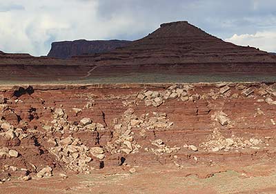 |
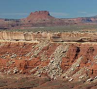
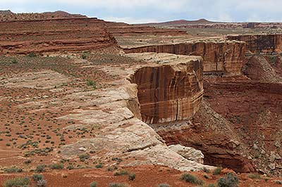
| The White Rim Sandstone is much thicker near the Green River (above left) than it is on the east side (above right) of the White Rim Road. |