|
Hiking
Happenings March 2004
Walkabout with
Rory Tyler
According to Webster, March is “the
month of Mars”; a very disciplined if not always subtle
fellow. Or, as Webster also advises, March can mean “a
regular, steady pace or step.” My advice this month: renew
the discipline, eschew the subtlety, go forth on a regular and
steady pace, kill two definitions with one trope, and March!
There’s something to be said for a good, hard march. Need
to clear your mind? Catalyze your creativity? Burn some calories
and grease some miles? March!
 A march is not like a hike. You don’t poke and peek and
ponder. You glue your eyes on to ground (figuratively), take
a deep breath and go. Where? Nowhere…Somewhere…What’s
the difference? Marching is it’s own reward (particularly
after holiday hedonism, too much TV, and those lazy weekends
with a novel and a nosh). So crack the guilty whip, say hasta
la vista to the ephedra, and march, march, march!
A march is not like a hike. You don’t poke and peek and
ponder. You glue your eyes on to ground (figuratively), take
a deep breath and go. Where? Nowhere…Somewhere…What’s
the difference? Marching is it’s own reward (particularly
after holiday hedonism, too much TV, and those lazy weekends
with a novel and a nosh). So crack the guilty whip, say hasta
la vista to the ephedra, and march, march, march!
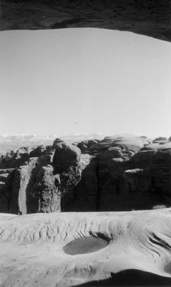
The
Courthouse Divide
( A good march for the novice. A light, panoramic patrol for
the veteran.)
This plateau separates Highway 191 and Courthouse Wash as
it wends through the center of Arches National Park. To get
there drive north on Hwy 191 about 6 miles to the turn-off
for the Bar M Chuckwagon. Take that turn, bypass the Bar M
(for now), and backtrack 1 ½ miles on the old highway.
At the top of the hill a road takes off to the east. Park
here if you have low clearance, but if you’ve got 4x4
you can drive almost two miles to the park boundary, but why
bother? Pretty flat and very pretty. Lot’s of acreage
and varied walking opportunities. Immediate rewards that multiply
as you…Left! Right! Left! Right!
A series of side canyons drops from the ridgeline into Courthouse
Wash to the east. These are phenomenal gorges replete with
soaring Entrada sandstone towers and undulating slickrock
and you need go no further to become ecstatic. But, for the
disciplined marcher, the ridge ends about two miles south
of the park boundary or 3 ½ miles from the turnoff.
This point overlooks the beautiful Park Place, one of the
most-visited places in the park, but you will be alone with
the raven’s view. If you need a destination, try for
this. It’s all good.
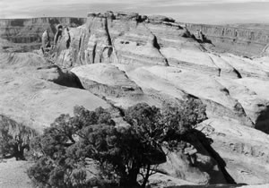 Amasa
Back Amasa
Back
The Amasa Back Trail is heavily used by bicycles and has moderate
four-wheel and motorcycle use. It’s still a good place
to go marching. What I particularly like about this area are
the phenomenal views. The trailhead is on Cane Creek Road
about a mile after it turns to gravel. The trail takes a short
drop into the canyon, then climbs about a mile up onto Amasa
Back, a long peninsula that creates a gooseneck in the Colorado
River. Once you reach the top of the hill the two-track road
is fairly level for miles and miles. The panoramas here constitute
a fabulous layering of river, canyon, precipitous Wingate
cliffs, undulating slickrock domes, and soaring snow-capped
peaks.
Once you come around the corner at the top of the hill, the
first prominent features you’ll see are three sandstone
buttes. The second of these, on your right, has some nice
rock art paintings, probably Basketmaker-style about 1,300
years old. The third and highest butte, on your left, has
a boulder on the far side that contains a nice dinosaur track-way.
An interesting option for hiking Amasa Back is to start at
the parking lot where Cane Creek meets the Colorado River,
right where the road turns to gravel. You can cross the creek
just below the parking lot and access an old caterpillar track
that ascends the north side of the peninsula for a couple
miles before you come close to the 4x4 road. This route affords
even better views, opportunities to chuck rocks hundreds of
feet down into the river (it’s a guy-thing), and almost
guarantees that you won’t be meeting other people.
| Cryptos
(krip’ tose): The surface of Moab’s
desert is held together by a thin skin of living organisms
known as cryptobiotic soil or cryptos. It has a lumpy
black appearance, is very fragile, and takes decades
to heal when it has been damaged. This soil is a critical
part of the survival of the desert. The cryptobiotic
organisms help to stabilize the soil, hold moisture,
and provide protection for germination of the seeds
of other plants.
Without it the dry areas of the
west would be much different. Although some disturbance
is normal and helps the soil to capture moisture, excessive
disturbance by hooves, bicycle tires and hiking boots
has been shown to destroy the cryptobiotic organisms
and their contribution to the soil. When you walk around
Moab avoid crushing the cryptos. Stay on trails, walk
in washes, hop from stone to stone.
Whatever it takes, don’t
crunch the cryptos unless you absolutely have
to! |
The Most Boring Hike in Moab
It’s hard to imagine but, yes, there is a boring hike
in the Moab area. Take Hwy 191 north about 25 miles then head
off to the left, or west. This area is part of the Cisco Desert
and it’s nothing but a relentlessly flat, desolate,
dusty wasteland of hard pan clay and drab expanses of black
brush. One day, feeling desolate, depressed, and forlorn I
sought a landscape to commiserate with my deranged mood. This
place did the trick. Luckily, after marching aimlessly for
hours through this swale of sensory deprivation, I managed
to feel better. It must have been the endorphins. And now
I have a valuable, visceral recollection that I can use as
a metaphysical baseline for rating my other walks. I don’t
actually recommend that you take the same hike unless, perhaps,
you too find yourself under the baleful influence of an existential
ennui similar to that cited above.
Rory Tyler
leads custom rock art tours and backcountry hikes for people
of all skill levels for Canyon Voyages Adventure Company.
|