|
|
Trail HAPPENINGS December 2015
|
Nordic Skiing In The La Sal Mountains
by Kirstin Peterson |
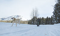
Winter is early this year in the La Sal Mountains, presenting a dramatic backdrop to our red rock desert. When the snow arrives, the small mountain range beckons and people flock to enjoy our own private winter wonderland and all the recreational opportunities that exist just 45 minutes from Moab. Whether you prefer skinny or fat skis, telemark or randonee, classic or skating, snowboards or snowshoes, sledding or snowmobiling, there’s something for you in Moab’s upper extremes. Locals and visitors alike are lucky to have groomed trails in the La Sal Mountains which offer access for all kinds of winter recreationists.
LUNA (Lower Utah Nordic Alliance) is a group of dedicated volunteers who work with the Manti-La Sal Forest Service to provide a groomed Nordic track system starting from the Geyser Pass Trailhead. Beginning in early to mid-December or whenever the snowpack is established, LUNA volunteers use a system of 2 snowmobiles pulling grooming equipment to lay a Nordic track wide enough for skate skiing and with a set of parallel tracks on the side for classic skiers. LUNA is able to provide this service through support from both Grand County’s Trail Mix Committee and the Recreation Special Service District as well as from private donations.
.jpg) The starting point is the Geyser Pass Road winter trailhead at 9600 ft. and the groomed track goes up from there, where the elevations are higher yet and the air is thin. There are sections of the track that are suitable for all levels of skiers and snowshoe enthusiasts. As you set out from the parking area it is important to know that most of the track is “shared use” and you will see a variety of winter recreationists enjoying the mountains including snowmobilers, backcountry skiers and snowboarders, snowshoe and sledding parties with many canine companions. We ask everyone to please be courteous to other users, move right to allow others to safely pass and keep yourself under control when traveling downhill. The starting point is the Geyser Pass Road winter trailhead at 9600 ft. and the groomed track goes up from there, where the elevations are higher yet and the air is thin. There are sections of the track that are suitable for all levels of skiers and snowshoe enthusiasts. As you set out from the parking area it is important to know that most of the track is “shared use” and you will see a variety of winter recreationists enjoying the mountains including snowmobilers, backcountry skiers and snowboarders, snowshoe and sledding parties with many canine companions. We ask everyone to please be courteous to other users, move right to allow others to safely pass and keep yourself under control when traveling downhill.
The Meadow Loop is the easiest and closest track to the parking lot. Ski a short way uphill from the trailhead and you’ll see the Meadow Loop take off on the left and wind first through some aspens and then into a beautiful open meadow with Haystack Mountain in the background. The terrain is rolling and the loop rejoins the main track close to where you entered. This .3 mile sunny loop is fun to ski in either direction and is the perfect place to work on your form and get your lungs used to the high elevation.
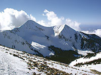
.jpg) Gold Basin is an intermediate track and is reached by continuing up the main Geyser Pass Road track from the Meadow Loop to the intersection with the Gold Basin Road, which branches right. The Gold Basin Track is rolling, both out and returning, and offers a peaceful ski through pines and aspens with occasional views of the red rock desert below. You may see backcountry skiers accessing many of the popular runs above the track or returning from turns in the powder. The Gold Basin Track ends at the point where motorized travel is prohibited from going further, thus making this an out and back excursion totaling 8 km (5 miles) round trip from the trailhead. Gold Basin is an intermediate track and is reached by continuing up the main Geyser Pass Road track from the Meadow Loop to the intersection with the Gold Basin Road, which branches right. The Gold Basin Track is rolling, both out and returning, and offers a peaceful ski through pines and aspens with occasional views of the red rock desert below. You may see backcountry skiers accessing many of the popular runs above the track or returning from turns in the powder. The Gold Basin Track ends at the point where motorized travel is prohibited from going further, thus making this an out and back excursion totaling 8 km (5 miles) round trip from the trailhead.
For the ambitious and fit skier, Geyser Pass and the La Sal Loppet Loop, which branches off at the top of the pass, offers a challenging and beautiful Nordic skiing experience. From the Gold Basin intersection, Geyser Pass is another 2 miles (3.5 km) mostly uphill. Geyser Pass tops out at 10,600 ft and the La Sal Loppet Loop takes off to the right along the road towards Dark Canyon. After approximately .5 miles, the track leaves the main route on the left and winds through open meadows to a point offering wide ranging views of Colorado including the stunning San Miguel and Wilson mountains near Telluride. This rolling loop continues through the trees and emerges on the east side of the Geyser Pass Road where you will take a left up a short hill back to the pass, adding an additional 1.8 miles (3 km) to your distance (8.6 miles/13.2 km total from trailhead). From the pass is it mostly downhill back to the trailhead so be sure to have a warmer wind protective layer for the descent.
 Directions to trailhead: From Moab head south on Hwy 191 to the La Sal Mountain Loop Rd turn off at the south end of Spanish Valley. Turn left off the Hwy and then right onto the Loop Rd for about 13 miles to a well marked turn onto Geyser Pass Rd. From here travel 3.5 miles to the trailhead. Note that snow tires and/or 4wd are recommended for this road. The road is plowed fairly regularly but call 435-259-7155 or check http://utahavalanchecenter.org/advisory/moab for current conditions and the latest information about road clearing. Be prepared for winter conditions in the mountains and bring appropriate warm clothing, water, and food for any outing into the backcountry. There are no services other than toilet facilities at the trailhead. Directions to trailhead: From Moab head south on Hwy 191 to the La Sal Mountain Loop Rd turn off at the south end of Spanish Valley. Turn left off the Hwy and then right onto the Loop Rd for about 13 miles to a well marked turn onto Geyser Pass Rd. From here travel 3.5 miles to the trailhead. Note that snow tires and/or 4wd are recommended for this road. The road is plowed fairly regularly but call 435-259-7155 or check http://utahavalanchecenter.org/advisory/moab for current conditions and the latest information about road clearing. Be prepared for winter conditions in the mountains and bring appropriate warm clothing, water, and food for any outing into the backcountry. There are no services other than toilet facilities at the trailhead.
About the Author: The Author, Kirstin Peterson is the ski representative for Trail Mix, the Grand County Non Motorized Tails Advisory Committee when she’s not running her mountain bike tour company: Rim Tours. Trail Mix is a contributor to the ski grooming program. Come to the Trail Mix meetings held the second Tuesday of each month 12-2 at the Grand Center, 500W. 182 N. to join hikers, bikers, skiers, and equestrians in our effort to develop and maintain non motorized trails. Contact Sandy Freethey for more information. sngmoab@preciscom.net .
 Trail Mix This committee represents non motorized trail users including: bikers, hikers, equestrians, and skiers. Many government agencies and private citizens comprise the “mix” that makes this group work so well. We meet the 2nd Tues. of each month from 12-2 at the Grand Center (500W. 182 N.). Everyone is welcome. Trail Mix This committee represents non motorized trail users including: bikers, hikers, equestrians, and skiers. Many government agencies and private citizens comprise the “mix” that makes this group work so well. We meet the 2nd Tues. of each month from 12-2 at the Grand Center (500W. 182 N.). Everyone is welcome.
Contact Sandy Freethey 259-0253 or find us online: wwwgrandcountyutah.net/trailmix/ or at moabtrailmixinfo@gmail.com.
|
|
Nordic Skiing In The La Sal Mountains
by Kirstin Peterson |
The snow capped peaks of the La Sal Mountains are most often viewed as a scenic backdrop for the stunnning red rock landscape that surrounds them. But with an average snowfall of 250 inches a year, the mountain ranges hosts a variety of winter recreation opportunities including backcountry skiing and snowboarding, snowmobiling, snowshoeing, and cross country skiing on groomed trails.
Winter access to the mountains is provided from two routes kept open by the Grand and San Juan County Road Departments. The La Sal Mountain Loop Road provides access to a parking area at the Geyser Pass Winter Trailhead at 9,600 ft. Just below the parking area is a hill popular for sledding. If you are sledding on this hill, please park in the parking lot, not at the base of the hill so other vehicles can get through. The popular Geyser Pass trailhead provides access for backcountry skiing and snowboarding in Gold Basin, as well as access to 12 kilometers of groomed trail courtesy of a partnership between the Manti-La Sa National Forest, and volunteers from the Lower Utah Nordic Alliance (LUNA). Because these routes are open to everyone, please be respectful of different users. If you are snowmobiling on these groomed routes, please go uphill on the right and downhill on the left to avoid conflict with cross country skiers.
 About a mile and a half up from the Geyser Pass trailhead, a right fork takes you into Gold Basin. This dead end road is groomed, and used extensively by cross country skiers. Motorized use is not permitted off the road into Gold Basin, and the Forest Service would like to encourage motorized users to avoid use of the Gold Basin road and continue up to Geyser Pass, where abundant meadows and hills provide excellent snowmobiling opportunities. About a mile and a half up from the Geyser Pass trailhead, a right fork takes you into Gold Basin. This dead end road is groomed, and used extensively by cross country skiers. Motorized use is not permitted off the road into Gold Basin, and the Forest Service would like to encourage motorized users to avoid use of the Gold Basin road and continue up to Geyser Pass, where abundant meadows and hills provide excellent snowmobiling opportunities.
The second plowed access is around on the east side of the range, and provides access to some of the mountain’s best snowmobiling terrrain. To access this trailhead, take Highway 191 south of Moab for 22 miles to the junction with Highway 46. Turn here towards the town of La Sal. 3.5 miles past La Sal, turn left on the Upper Two Mile Road and continue two more miles to the marked trailhead for La Sal Pass. From here, riders can snowmobile up the road to the pass, where open meadows, rolling terrain, and hill climbing opportunities for all skill levels abound. You can also continue on the Upper Two Mile Road for about five more miles to the Dark Canyon Trailhead.
Non-Motorized Closure
The vast majority of the La Sal Mountains is open to winter, motorized recreation, but the alpine area surrounding the middle group of the mountain range including Gold Basin is closed to motorized use. This area is defined as the terrain east, and at the end of the Gold Basin Road; and the terrain south of the Geyser Pass road above the Gold Basin turnoff. All of the area around Geyser Pass is open to motorized use and provides excellent snowmobiling terrain.
Avalanche Hazard in the La Sal Mountains
The La Sal Mountains are exceedingly avalanche prone due to a combination of steep terrain, and a shallow snowpack that is prone to the formation of weak layers. Users are encouraged to keep abreast of current snow and avalanche conditions on the web at www.utahavalanchecenter.org or by calling 435-259-SNOW (7669). Travelers who venture into avalanche terrain should carry appropriate rescue gear: beacon, shovel and probe, and know how to use them. If in doubt about your avalanche awareness or rescue skills, the Utah Avalanche Center also offers training courses in avalanche safety. Please contact them for more information.
|
|
|
|
|
|
© 2002-2026 Moab Happenings. All rights
reserved.
Reproduction of information contained in this site is
expressly prohibited.
|
|