Trail Happenings August 2010
The Hazzard County Trail – a Summer Hiking Opportunity
by Katie Stevens, Trail Mix member
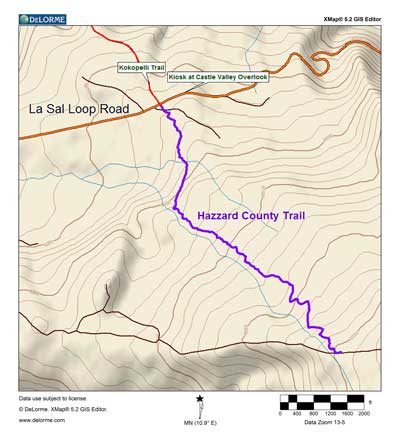 Hazzard County is the curious name of a designated bicycle trail in the Manti-La Sal National Forest (Moab District) that also affords a slower group of users—hikers —a wonderful opportunity to enjoy their National Forest lands. The recently constructed single-track trail links the La Sal Mountain Loop Road and Warner Lake, gaining 1200 feet in elevation over three miles. It is usually ridden by mountain bikers as part of the Whole Enchilada Trail, which starts at Burro Pass, descends to Warner Lake, and continues on to Upper Porcupine Singletrack, Lower Porcupine Singletrack and the Porcupine Rim Trail to Highway 128. Hazzard County is the curious name of a designated bicycle trail in the Manti-La Sal National Forest (Moab District) that also affords a slower group of users—hikers —a wonderful opportunity to enjoy their National Forest lands. The recently constructed single-track trail links the La Sal Mountain Loop Road and Warner Lake, gaining 1200 feet in elevation over three miles. It is usually ridden by mountain bikers as part of the Whole Enchilada Trail, which starts at Burro Pass, descends to Warner Lake, and continues on to Upper Porcupine Singletrack, Lower Porcupine Singletrack and the Porcupine Rim Trail to Highway 128.
Hazzard County starts off in a southerly direction into the gambrel oak at 8300 feet in elevation. Soon thereafter, the trail starts to ascend into several copses of aspen trees. Views of the surrounding desert and red rock country start almost immediately, and hikers can appreciate them while gaining elevation through the green vegetation. Hikers who started in the heat of the desert are cooled merely by being surrounded by the lush vegetation.
The aspen interludes provide welcome shade and a different life zone in the forest. After several of these aspen to oak interfaces, the trail enters a wide open area where hikers can enjoy views of Moab’s valley and the higher peaks of the La Sal Mountains, as well as the more distant Abajo and Henry Mountains. Boulder Mountain is visible as well as a good slice of the Utah red rock desert from the town of Moab to Torrey. The Trail continues to ascend this upward sloping wide open area to a ridge. From the crest of the ridge, it feels like the top of the world with views in every direction. The trail then descends the ridge, and intersects the Warner Lake Road. It is a short walk on to Warner Lake, where there are restrooms, picnic tables and campsites.
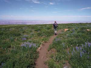 Turning around to retrace your steps to the La Sal Mountain Loop is twice the fun, since the views are even more spectacular than the uphill route. The easy grade and excellent trail tread makes the downhill walk almost effortless, enabling you to concentrate on the scenery displayed before you. Turning around to retrace your steps to the La Sal Mountain Loop is twice the fun, since the views are even more spectacular than the uphill route. The easy grade and excellent trail tread makes the downhill walk almost effortless, enabling you to concentrate on the scenery displayed before you.
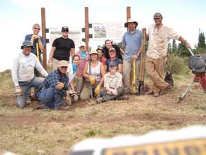
The Hazzard County Trail was constructed by the U.S. Forest Service, with help from Grand County’s Trail Mix Committee as well as other volunteers. The trail was the product of efforts to link Warner Lake and the Kokopelli’s Trail, to provide downhill mountain bike opportunities from the higher elevations of the Forest all the way into the City of Moab. Care was taken to site the trail with environmental issues in mind, especially the wildlife habitats which are found in the mountains. The layout and engineering of the trail, as well as its construction, were very carefully undertaken. Wide turns and easy ascents mean that elevation is gained almost without effort. The trail builders obviously worked hard to maintain the wonderful views of the mountains and the surrounding scenery. Inadvertently, a wonderful hiking opportunity was established in the La Sal Mountains.
Hazzard County also gives a glimpse of the “working forest”. At certain times of the year, you may find cattle grazing on the mountainside. The communications lifeblood of Moab, the Bald Mountain Repeater Site, can be seen from much of the trail. A constructed ditch, which provides water from the high country to the agricultural fields below, parallels the trail for a short time. And don’t forget the animals including deer who find this prime grazing in the summer months.
While Hazzard County is considered a mountain bike trail, it is open to all non-motorized users. Most mountain bikers take a shuttle ride to the top and ride downhill only. Hikers need to be aware that downhill bikers will be going much faster than walking speed, but there are generally very good sight lines. On a wonderful summer holiday weekend this year, only five bikers were encountered on a round-trip hike. However, in the fall, which is prime biking season, hikers should expect to encounter many groups of downhill cyclists.
 The origin of the name “Hazzard County” is uncertain. Hazzard County, Kentucky, a coal mining area, is one possibility, but it is more likely that the trail was named for the “Dukes of Hazzard”, an old TV show. Whatever the origin of the name, this trail is a wonderful hiking experience. The origin of the name “Hazzard County” is uncertain. Hazzard County, Kentucky, a coal mining area, is one possibility, but it is more likely that the trail was named for the “Dukes of Hazzard”, an old TV show. Whatever the origin of the name, this trail is a wonderful hiking experience.
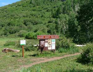
To find the trailhead, drive south from Moab past Ken’s Lake taking the Mountain Loop Road. Drive past the turnoffs to Geyser Pass, Warner Lake and Sand Flats. Then look for a widening of the road with spectacular views of Castle Valley and Castleton Rock. Park here. The Hazzard County Trail (small sign) joins the La Sal Mountain Loop Road immediately south of where the Kokopelli Trail (large sign) leaves the Loop Road.
Trail Mix is an advisory committee to Grand County in the development and maintenance of non motorized trails. The committee represents non motorized users including bikers, hikers, equestrians, and skiers. Many government agencies and private citizens make up the “mix” that makes this group work so well. Come join us on the 2nd Tues. of each month from 12-2 at the Grand Center (500W. 182 N.). Everyone is welcome. Contact Sandy Freethey 259-0253 or find us online at wwwgrandcountyutah.net/trailmix/. You may also reach us at moabtrailmixinfo@gmail.com.
 Trail Mix is an advisory committee to Grand County in the development and maintenance of non motorized trails. The Committee represents bikers, hikers, equestrians and skiers. Many government agencies and private citizens make up the “mix” that makes this group work so well. Come join us on the 2nd Tues. of each month from 12-2 at the Grand Center (500 West -182 North). Everyone is welcome. Trail Mix is an advisory committee to Grand County in the development and maintenance of non motorized trails. The Committee represents bikers, hikers, equestrians and skiers. Many government agencies and private citizens make up the “mix” that makes this group work so well. Come join us on the 2nd Tues. of each month from 12-2 at the Grand Center (500 West -182 North). Everyone is welcome.
Contact Sandy Freethey 259-0253 or find us online at wwwgrandcountyutah.net/trailmix/. You may also reach us at moabtrailmixinfo@gmail.com.
|
|