Trail Happenings July 2009
Two Local Groups Working Behind the Scene for Trails
“TRAIL MIX” - THE GRAND COUNTY TRAIL MIX COMMITTEE: “Trail Mix” is not a breakfast food, but refers to the “mix” of agencies and private citizens who make up the group. Trail Mix represents a variety of trail users including; hikers, bikers, equestrians and skiers. The committee works with the Bureau of Land Management, Forest Service, State and National Parks, the County, City and private land owners to develop a connected network of non-motorized trails to serve locals and visitors. Trail Mix utilizes paid trail specialists and volunteers to build and assist with the maintenance of the trails in the County. Anyone can get involved and our trail network will only improve with more volunteers. You can help make a difference, and it’s FUN! TRAIL MIX MEETINGS: Second Tuesday of every month at the Grand Center (182 N. 500 W.) Noon-2:00. Sandy Freethey Chair, David Olsen is Vice Chair. Everyone is welcome to attend.
TRAIL NEWS AND UPDATES
The Whole Enchilada Trail System is now complete. The Upper Porcupine Singletrack (UPS) section was re-routed to protect raptors and cultural resources before receiving approval by the Forest Service. The Whole Enchilada Trail starts at the Burro Pass Trailhead in the La Sal Mts. and continues for about 25 miles down to Hwy 128, (the River Road), linking the Burro Pass Trail with Hazzard County, UPS, LPS & Porcupine Rim Trails. Ride all or part of the trail and enjoy the great views of Castle Valley and the La Sal Mts.
Dead Horse State Park opens the new Intrepid Bike Trail System. The trails offer splendid views and varied riding terrain for beginners and intermediates. Bike trail loops range from one to nine miles. If you are not a biker the State Park also has some wonderful hiking trails to enjoy.
BULLETIN AND WARNING
A word about illegal “user created” bike trails on Forest Service, BLM and National Park lands: Bikers who are caught riding on illegal trails may be fined! The use and promotion of illegal trails jeopardizes the Trail Mix Committee’s ability to create new trails by working within the legal process set forth by the agencies. Get involved, work within the system.
Stay on the Designated Trails! |
|
“MTA” - MOAB TRAILS ALLIANCE: is a 501 (c) 3 non profit funded by Moab businesses and concerned citizens whose mission statement is “To promote responsible trail use through private and public partnerships with an emphasis on non-motorized trail networks.” MTA advocates for and writes grants to fund the creation of an alternative transportation system to serve Grand County’s growing needs. All donations are tax deductible and may be sent to 210 East 300 South, Moab, Utah 84532. We have many worthy projects that can use your funding. For additional Information contact Kim Schappert at 435-260-8197.
VOLUNTEER OPPORTUNITIES:
Trail Building - No special skills are needed. Contact Jeff Fink 259-8994, David Olsen 259-5129 or Jeff Van Horn 260-9953 to set up a time to help.
Maintenance and Restoration Projects include: shoveling, raking, sign installation, mowing, weeding, pruning, fencing and painting. Contact Sandy Freethey 259-0253 or David Olsen 259-5129.
Adopt-A-Trail - If you have a favorite trail that you ride or hike please consider volunteering to do light maintenance on the trail. For additional information call Sandy Freethey at 259-0253.
Donate - Do you have a small tractor that you would like to operate for the maintenance of our paved paths? Sand removal and sweeping needed. Don’t have a tractor? Donate some money to the “Buy a Tractor Fund” See MTA above.
TRAIL OF THE MONTH:
Burro Pass to Warner Lake
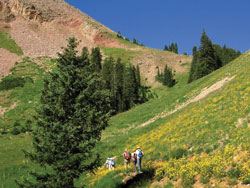 Marc Thomas photo
 |
Beat the heat and hike in the La Sal Mountains! The hiking trail is 4.2miles one way to Warner Lake.
Part of the trail is over 11,000’ so hikers should bring clothing for all weather conditions including snow, hail, rain, and strong winds and be physically able to handle the altitude. As always, bring water, food and a map. The trail offers gorgeous views of, (and access to) Manns Peak and Mount Tomasaki. There are often waist high flowers along the trail and the Wet Fork of Mill Creek is beautiful as it meanders through Aspen groves. From Moab, drive south to access the La Sal Loop Road.
Continue up the mountain road until you reach the Geyser Pass Road (FS 71) and then turn right. Drive 7.7 miles to the top of the pass and remain on FS 71 which turns left at a fork and drive 1.2 miles, then turn left again onto a spur road FS 240 and continue for six tenths of a mile on a high clearance road to the trailhead. The trail to Burro Pass starts at the register box and ends at Warner Lake with 700’ of elevation gain making a nice one way hike, but you will need to shuttle a car to the Warner Lake Campground. As the hiking trail approaches Warner Lake stay right so that you don’t end up at Oowah Lake. Guidebooks and maps are available on La Sal Mountain trails for additional details. |