Grand County Ghost
Towns
by Jeff Richards
October is always a good
time for ghostly happenings. Although Grand County doesn’t
appear to have many legends involving actual ghosts or haunted
houses, it is home to several ghost towns. Most are mining
camps that died decades ago. Here’s a short guide
to some of the more well-known ghost towns in Grand County:
 |
Miners Basin |
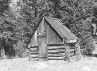
MINER’S BASIN, also
known as simply Basin, was a mining town at over 10,000
feet elevation on Mt. Waas in the La Sal Mountains. With
a peak population of about 75 or 80, the town flourished
for about 20 years after gold was discovered there in the
late 1880s. The first claims were staked in the area around
1888, and a formal mining district was organized 10 years
later. Silver and copper were also mined in limited quantities,
in addition to gold. At its heyday, the town boasted a hotel,
a store, two restaurants, a blacksmith shop, a post office,
and two saloons. However, the mines were closed in
1907 as a result of a nationwide financial panic, and the
town died shortly thereafter. Even so, a few diehard miners
remained on the mountain for decades afterward. A few log
cabins and other structures still remain in the area.
Just down the mountain from Miner’s Basin was CASTLETON,
a bustling mining supply center located not far from the
present day town of Castle Valley. It was reportedly first
settled by Doby Brown, a prospector, in the early 1880s.
A post office was established in Castleton in 1882, and
numerous other buildings soon followed. Castleton not only
boomed along with Miner’s Basin, it also died along
with it when the mines closed in 1907. Today, the remains
of Castleton can be seen some 10 miles southeast of the
Castle Valley turnoff of state highway 128.
|
Sego |
| |
 |
Sego |
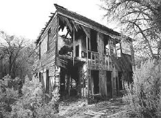
SEGO boasted a population
of nearly 500 people more than 80 years ago. Located in
Sego Canyon five miles north of Thompson Springs, Sego began
its existence as a coal mining camp for American Fuel Company
workers who had begun working Henry Ballard’s coal
mine in the Book Cliffs area around 1912. The coal from
the mine was loaded onto railroad cars and transported down
a five-and-a-half mile railroad spur to Thompson. The town
was originally known as Neslen at first, and was notable
for its racially segregated housing. In 1918, the town’s
name was changed to Sego (in honor of Utah’s state
flower) when Chesterfield Coal Company bought out AFC. The
mine, which struggled financially throughout much of its
existence, closed for good in 1947. Today, a few ramshackle
buildings remain, including the old store, a two-story wooden
boarding house, along with a few dugout cabins, an explosives
bunker, and several old foundations.
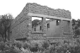
CISCO was a watering stop for railroad steam engines
beginning in the 1880s. Cattle ranchers and sheepherders
in the nearby Book Cliffs to the north later used Cisco
as a livestock shipping and supply center. The town, which
had a population of several hundred people as late as the
1930s, was also at one time the largest producer of oil
and natural gas in the state. However, the town’s
economy declined over the years, and the construction of
the Interstate 70 highway (which bypassed the town entirely)
proved to be the final nail in its coffin. Today, a few
dozen dilapidated buildings are sprawled across a mile or
so of land, interspersed with a few lived-in homes inhabited
by Cisco’s few present-day residents. Cisco is about
6 miles southwest of I-70 Exit 220 and about 50 miles east
of Green River.
PLAINSFIELD was located just south of the Grand-San Juan
County line in the “Poverty Flats” area of southern
Spanish Valley, somewhere near or in between the Old Airport
hangar and Ken’s Lake. Virtually no evidence remains
of the town’s existence. One of its earliest residents
was noted pioneer John Henry Shafer, who settled the Plainsfield
area in 1878 along with fellow rancher C.M. Van Buren. A
petition for a post office was granted in 1879, but was
discontinued the following year. Problems with hostile Native
Americans caused the first Plainsfield settlers to close
the fort and move closer to town. However, in 1883, four
other families (Somerville, McConkie, Newell, and Johnson)
moved from elsewhere in San Juan County to the Plainsfield
area. Jennie Somerville, daughter of Mr. and Mrs. Andrew
Somerville, was reportedly the first baby ever born in the
fledgling community. Throughout the 1880s, school was taught
and LDS church meetings were held at the McConkie home in
Plainsfield. Because water was scarce, Plainsfield residents
had to go down the valley three or four miles to the Boren
Ranch (now the George White Ranch) to obtain drinking water
from the springs. By the early 1900s, however, Plainsfield
was nothing more than a memory.
WILSON MESA, also known as simply Mesa, was located on the
western slope of the La Sal Mountains. It actually consisted
of two mesas, North Mesa and South Mesa, which were separated
by a small canyon called Left Hand. These mesas, which still
contain ranches, are accessible from the present-day La
Sal Mountain Loop Road. Wilson Mesa was first settled by
Joseph Burkholder and Herbert Day in 1891. Other early settlers
included the Shafers, the Johnsons, the Diffendorfs, and
the Fillmores. Wilson Mesa took its name from cattleman
A.G. Wilson, who grazed about 500 cattle in Spanish Valley,
the Sand Flats, and on the mesa itself. A post office existed
in Mesa from 1907 to 1923. One notable accomplishment by
Mesa settlers was the construction of an impressive tramway
to lower 1,200 pounds of produce at a time from South Mesa
to the Mill Creek area some 2,000 vertical feet below. The
Murphy brothers built the tram around 1916. Supplies could
also be hoisted up the tramway, provided that the down-going
load was heavier.
RICHARDSON is a nearly forgotten town named after its founder,
Professor Richardson, who in 1879 settled at the mouth of
Professor Creek (also named after him). He built a cabin
which later became a store when he built his home in nearby
Professor Valley. Professor Creek was a strategic waterway
used by early residents to float supplies from the railroad
stop at Cisco down to Castle Valley. Richardson had an official
post office from 1886 until 1905. Today, only a couple of
ranches remain in the area.
VALLEY CITY, a few miles south of present-day Crescent Junction,
was once a thriving farming community. It was born around
1905, when the Grand Valley Land and Mineral Company had
men working on a reservoir near Thompson that would irrigate
some 2,500 acres of land. However, because the company had
little cash on hand (its treasurer had reportedly bet a
bundle at the racetrack and lost) a dirt dam was substituted
for the originally planned cement dam. Three years later,
sixty acres of orchard were being irrigated with dam water.
But a torrential rainstorm then washed away the dam, not
to mention the dreams of those who had invested their time,
money, and hard work into the project. The dam was later
rebuilt, however, and the town of Valley City had a schoolteacher
in the 1920s and early 1930s. However, the periodic flash
floods proved to be too much of a threat, and eventually
everyone moved away. Today, only traces of a single building
foundation remain.
 |
Elgin |
Other area ghost towns,
some of which have a few modern-day residents, include ELGIN
(near Green River), DEWEY (home of the famous Dewey Bridge,
a suspension bridge constructed in 1916), and WESTWATER
(which reportedly once seriously rivaled Moab as the county’s
largest city the late 1890s). For more information on the
history of Grand County and its various old towns, visit
the Dan O’Laurie Canyon Country Museum at 117 East
Center Street in Moab.
 Moab
Historic Happenings October 2003
Moab
Historic Happenings October 2003