In my March column I introduced my readers to the Potash Road leading from U.S. 191 to the mining operation from which it gets its name. This month we’re going to go beyond that, for where the pavement ends the Potash Road becomes a Jeep track leading to the Shafer Trail and up a cliff face to the Island in the Sky in Canyonlands National Park. Hang on, for it’s a bumpy ride – but well worth it if you have a high clearance vehicle.
Unless you want to see everything twice, this route is usually taken as a loop, and you can go either up or down. If you choose to go up, you begin at the end of the pavement on Potash Road and continue up to Canyonlands National Park and back to Moab via Route 313.
Or, you can go up to Island in the Sky, come down the Shafer Trail and follow the Jeep trail back to the pavement near the potash processing mill. While either can be fun, I prefer coming down from the top because that way you get to see the landscapes appear before you. I will describe the route in this way.
Just after you pass through the entrance station at Island in the Sky, look for a road on the left directing you to the Shafer Trail. This is a sinuous series of steep switchbacks that leads you virtually down the face of a cliff well over a thousand feet high.
Although 4WD is not required during most conditions, be sure you have a high clearance vehicle (no, best to leave your low-slung Prius on the highway where it belongs). However, the trail is not particularly challenging when compared with most of the Jeep trails around Moab. For example, I recently saw a pair of VW microbuses successfully doing the route. If you have 4WD with a low-range option, it’s a good idea to use that to get more engine braking and torque.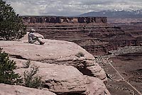
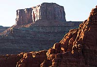
Shortly after you begin to negotiate the trail you will come to a slickrock viewing area offering vast views of Shafer Canyon, as seen in Fig. 1. Below is the trail you will follow after descending from the high plateau.
Tale your time when winding your way down the hairpin turns. The trail is graded and well maintained by the Park Service but may be intimidating to those with a touch of acrophobia. Be sure to watch for oncoming traffic and prepare to yield and pass safely.
 Once you get down to the “flats” below you will come to a fork in the road. Going straight leads to another route, the White Rim Trail that circumnavigates the Island in the Sky. You will take a left and continue to follow the Shafer Canyon. Once you get down to the “flats” below you will come to a fork in the road. Going straight leads to another route, the White Rim Trail that circumnavigates the Island in the Sky. You will take a left and continue to follow the Shafer Canyon.
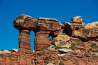
Soon you will come to strange hammer-like features – in fact I call them “Thor’s Hammers” (although they may have some other name I have not heard). As seen in Fig. 2, they are pillars of red sandstone capped by flat capstones of White Rim sandstone.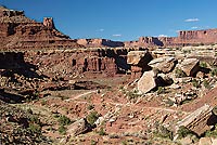
The trail continues to follow Shafer Canyon through a maze-like landscape, as seen in Fig. 3, which shows fallen chunks of the hard White Rim rock.
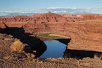 Before long the trail emerges along a wide ledge along the Colorado River, with side paths leading to several viewpoints overlooking the Gooseneck curves in the winding canyon. It was at one of these points that the final scene in the movie Thelma and Louise was made, in which a Ford Thunderbird was filmed “driving” off the cliff and into the river below carrying dummies of the ill-fated duo. Fig. 4 shows a view of the river from Thelma and Louise Point, looking east toward the La Sal Mountains. Before long the trail emerges along a wide ledge along the Colorado River, with side paths leading to several viewpoints overlooking the Gooseneck curves in the winding canyon. It was at one of these points that the final scene in the movie Thelma and Louise was made, in which a Ford Thunderbird was filmed “driving” off the cliff and into the river below carrying dummies of the ill-fated duo. Fig. 4 shows a view of the river from Thelma and Louise Point, looking east toward the La Sal Mountains.
 Look up and you will see the massive, block-like formation that is Dead Horse Point, as pictured in Fig. 5. Visitors to the State Park look down at the winding canyons from above, while you are privileged to be right in the center of the action. Look up and you will see the massive, block-like formation that is Dead Horse Point, as pictured in Fig. 5. Visitors to the State Park look down at the winding canyons from above, while you are privileged to be right in the center of the action.
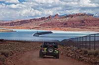
Continuing on you will eventually approach the potash mining operation, with its several hundred acres of evaporation ponds in which the potash is separated from the water used to remove it from huge salt beds far below ground. In Fig. 6 a Jeep approaches some of the settling ponds.
 There are other features too numerous to report in this brief article, including a massive balanced rock that I call “The Hen,” because it resembles a giant hen sitting on a single egg. You will pass through the potash mining property and come back to the paved portion of Potash Road. There are other features too numerous to report in this brief article, including a massive balanced rock that I call “The Hen,” because it resembles a giant hen sitting on a single egg. You will pass through the potash mining property and come back to the paved portion of Potash Road.
If you are a watcher of HBO, you may be interested to know that the special series Westworld, starring Anthony Hopkins, was largely filmed on the Potash Jeep trail along the river’s rim. If you get a chance to see a re-run, you will recognize many of the scenic spots you have just visited.
_______________________________________________
David L. Brown is a photographer, journalist and novelist who lives in Moab, where he leads photo tours and workshops. He can be reached at 435-210-8158 and his web site is at www.imagequest.photo
|