In the first of my new series of articles about great places to make pictures in the Moab area (March Happenings)
I introduced my readers to features along Potash Road. This time we’ll explore the other side of the Colorado River, a path that takes us into Kane Creek Canyon, then via a Jeep trail across Hurrah Pass and on to Chicken Corners Road.
Like many Moab area locations, this is a feast of red rock wonderlands, with hidden canyons, towering cliffs and majestic vistas. It all starts when you turn onto Kane Creek Road at the southwest corner of town. Passing the wildlife preserve, you will soon find yourself driving along the left bank of the Colorado.
 A couple of miles on you will come to Moonflower Canyon, a narrow defile guarded by several ancient cottonwood trees. Try capturing images of the spreading branches with your camera. Here you will find a panel of petroglyphs, a reminder of those who came before. Sadly, this is one of the most vandalized panels in the area. For those so inclined a ladder made from notched logs takes you up a narrow crack to the top of the bluff. A couple of miles on you will come to Moonflower Canyon, a narrow defile guarded by several ancient cottonwood trees. Try capturing images of the spreading branches with your camera. Here you will find a panel of petroglyphs, a reminder of those who came before. Sadly, this is one of the most vandalized panels in the area. For those so inclined a ladder made from notched logs takes you up a narrow crack to the top of the bluff.
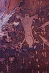
Continue on until the paved road turns to gravel and soon you will turn into Kane Creek Canyon. A couple of miles on watch to the right for a large boulder surrounded by what looks like a rail fence. This is Birthing Rock, one of the most interesting petroglyph sites in the area. It takes its name of the image of a woman giving birth and surrounded by baby footprints (Fig. 1). 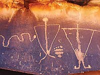 There are many other pecked images on this rock. There are many other pecked images on this rock.
Walk around to the right side and you will see several petroglyphs featuring Boötes, the Herdsman, a constellation described by the ancient Greek historian Herodotus. I discovered this alignment while photographing the Milky Way at this site a couple of years ago. When examining the petroglyphs by flashlight, then turning around to look at the constellation in the northern sky, the identification was unmistakable, including Arcturus, the second brightest star in the sky forming the head of Boötes (Fig. 2).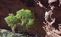
Continue on and you will go down a steep switchback into the canyon with its lush cottonwood trees, as seen in Fig. 3. Notice the pretty contrast between spring leaves and stark red rocks.
About a mile further on you will come to Hunter Canyon, a lovely spot for an early morning hike. Hunter is similar to Granstaff (formerly Negro Bill) Canyon, but without the large numbers of hikers. There are numerous photographic opportunities here, including flowering cacti and other plants in season. Walk about 200 yards past the walk-in campsites to the trailhead. The canyon is about three miles long.
 As you continue Kane Creek Canyon opens out to a wide valley and eventually you will come to a fork in the road. If you have a high-clearance vehicle, take a right to explore Hurrah Pass. As you ascend to the west you can photograph wide views of the Kane Creek Canyon and myriad hoodoo rock formations. At the pass you will again glimpse the canyon of the Colorado River with distant Dead Horse Point and deep blue potash mining ponds. As you continue Kane Creek Canyon opens out to a wide valley and eventually you will come to a fork in the road. If you have a high-clearance vehicle, take a right to explore Hurrah Pass. As you ascend to the west you can photograph wide views of the Kane Creek Canyon and myriad hoodoo rock formations. At the pass you will again glimpse the canyon of the Colorado River with distant Dead Horse Point and deep blue potash mining ponds.
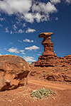
Now will be driving on Chicken Corners Jeep trail that winds back down toward the river. You will encounter an interesting pillar and balanced rock along the road. I captured a sunny day picture of this subject during a March trip (Fig. 4).
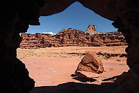 Going further you will see what looks like a huge pile of boulders to your left. Take a side trip to investigate and you will see that this formation is exactly what it looks like, a huge pile of boulders. Take time to explore the many “caves” formed among the rocks, offering the chance to make pictures such as Fig. 5, where I used one of the openings in the boulders to frame an image of a distant butte. Going further you will see what looks like a huge pile of boulders to your left. Take a side trip to investigate and you will see that this formation is exactly what it looks like, a huge pile of boulders. Take time to explore the many “caves” formed among the rocks, offering the chance to make pictures such as Fig. 5, where I used one of the openings in the boulders to frame an image of a distant butte.
Incidentally, the powers of Photoshop are illustrated in this picture, for a bright red side-by-side four-wheeler was parked right in the middle of the picture. I chose to digitally remove it and there is no sign of it or the man standing next to it in this version of the picture.
For the more adventurous the Chicken Corners trail becomes more challenging beyond this point and 4WD may be required. The trail climaxes with high viewpoints along the Colorado and across the canyon to looming Dead Horse Point.
Pack a lunch and plan to spend a day to explore Kane Creek Canyon and beyond. Later in the season there will be wild flowers, including many blooming yuccas to add interest to your landscape photos.
In upcoming articles I will continue to feature some of my favorite places to make photographs around Moab. If you want to share your personal favorites with me, or just to chat, please call at the phone number above or write me at david@dlbrown-inc.com. Thanks.
|