From the dawn of time, humans have looked skyward and watched clouds drift overhead. They may have wondered about a cloud’s origin, composition or foretelling of weather to come. We’ve all heard sayings like Red sky at night, sailors delight, but it wasn’t until 1802 that someone devised a naming system for clouds.
Luke Howard (1772-1864) was an English chemist, apothecary and amateur meteorologist who devised a classification system for clouds. Influenced by the nomenclatural work of Swedish naturalist Carl von Linne, known today as Linnaeus, Howard addressed the learned Askenian Society in London in 1802. His essay, “On the Modification of Clouds,” proposed a naming system for clouds and introduced such terms as “cirrus, nimbus, stratus and cumulus.” These terms mean “curl, rain, layer and heap,” respectively and with these Latin roots, Howard devised his naming scheme. This proposal by the “Namer of Clouds” still exists today, with some modifications.
Howard separated clouds into 10 basic types. His system followed the work of Linnaeus by using Latin terminology and a hierarchal system that organized the clouds into groups by altitude and form. About the same time, a Frenchman introduced a similar approach, but failed to use the international language of Latin and his proposal fell flat.
In 1956, the World Meteorological Organization officially adopted this classification system in their International Cloud Atlas. Today there are numerous varieties and “species” of clouds defined by their shape, internal composition, arrangement and association with accessory clouds.
About Clouds
High, middle and low elevations define the groups of clouds. High clouds reach between 16,500 and 50,000 feet in altitude and are known as cirrus clouds. Composed mainly of ice crystals, the three “cirriform” types are cirrus, cirrocumulus and cirrostratus. These three types first appear as wispy, brushstrokes high in the atmosphere. These cirrus or “mare’s tails” signal the possible approach of low pressure fronts or clear weather to follow. Cirrostratus clouds are those high elevation, thin layered clouds composed of ice crystals that may form rings or haloes around the sun or moon.
Although the cirriform clouds may produce precipitation, their high-elevation status insures the precipitation generally evaporates prior to reaching the ground.
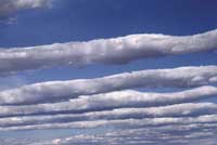
Mid-level clouds range between 6,500 and 16,500 feet. These are the altos – altostratus and altocumulus – comprised of water vapor and variable in shape. The grayish altostratus clouds may be thick enough to obscure the sun or to the give the impression of opaque glass. In contrast, altocumulus clouds form a variety of layered, lumpy or roll-like shapes. Their varieties are as lovely as their forms – altocumulus lacunaris, altocumulus lenticularis, and altocumulus castellanus to name a few.
Low clouds, from ground level to 6,500’ in altitude, are divided into stratus, nimbostratus, stratocumulus and cumulus clouds. Cumulus means “heap” and refers to the mashed potatolike clouds that build up during the summer months and spark the monsoon season. The flat-layered, gray nimbostratus clouds often result in long periods of rain or snow, not short-lived thunderstorms.
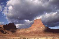
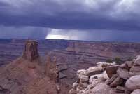
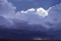
Cumulonimbus clouds, those masses of cottony air and water vapor, may result in spectacular storms. Although their bases may be near the ground, their tops generally reach up to 20,000’, but may reach as high as 70,000’ and as wide as the state of Rhode Island. Well, maybe Delaware.
There are some fun field guides to cloud identification including Peterson First Guide to Clouds and Weather, The Cloud Watcher’s Guide, and The Weather Wizard’s Cloud Book. A perfect May field outing is to lie on the ground and watch the parade of clouds drift overhead. I’m sure the “Namer of Clouds” would be pleased at such an undertaking.