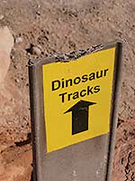
 On this deliciously warm day in late October, I am almost ready to embark on an exploration to investigate some rock art panels, dinosaur tracks and to find an arch. Any new-to-me trail, however, which advertises a rough route, makes me wonder if I’m taking on far more than I bargained for! On this deliciously warm day in late October, I am almost ready to embark on an exploration to investigate some rock art panels, dinosaur tracks and to find an arch. Any new-to-me trail, however, which advertises a rough route, makes me wonder if I’m taking on far more than I bargained for!
While loading up my pack I think about a hike I took from this same trailhead five years ago when I was on a mission to track down the legend of how the Poison Spider trail received its name. After walking four miles up to the mesa the artificial sunflowers drew me in. Next to the trail I found what I was looking for – the gravesite of Mary Jane Francis.– Bordered with stones, her name and the dates - 1889 to 1896 - are clearly carved on both headstones. This memorial has encouraged many to leave a tribute: a brake light, small teddy bear, toy rabbit, a Grinch, magic markers, comb, a big set of dice, cards, tic tac mints, two fake birds, an empty bottle of jaegermeister, necklaces and coins.
Now for the rest of the story – this young girl supposedly died after being bitten by a poison spider! Her grave is adorned for a tale that tells us so little, and the questions are endless. What did she look like? What was her personality like? Who were her parents, where did they come from, and what were they doing here? And most importantly – did she really die from the bite of a poison spider?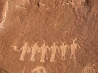
To get to the Poison Spider trailhead, from Moab drive north on Highway 191 for about four miles. Turn left on Highway 279 (Potash Road) and drive 5.9 miles. Then turn right at the sign and drive to the end of the parking area, where this hiker’s only trail begins between the billboards and the restroom.
A short climb brings me to a sign for a loop to view the dino tracks. First though to come into sight are some outstanding panels of petroglyphs that have lasted for thousands of years. Now I’m glued to the fascinating depictions of human figures holding hands, a faded circle, lots of squiggles, strange, oddly shaped animals, and bighorn sheep – one of them with a head on the front and the rear.
 Finally pulling myself away, the dinosaur tracks tell their story on big slabs of Navajo Sandstone – a reminder of the Therapods, such as Allosaurus, Eubrontes and Gallators, which roamed this area across the largest sand dune field ever recognized on earth! As these giant reptiles - fast moving bipedal carnivores with short arms and claws to grasp their prey - made their passages over wet surfaces 190 million years ago, they left behind their fossilized imprints. Finally pulling myself away, the dinosaur tracks tell their story on big slabs of Navajo Sandstone – a reminder of the Therapods, such as Allosaurus, Eubrontes and Gallators, which roamed this area across the largest sand dune field ever recognized on earth! As these giant reptiles - fast moving bipedal carnivores with short arms and claws to grasp their prey - made their passages over wet surfaces 190 million years ago, they left behind their fossilized imprints.
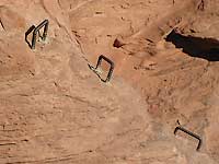
Continuing upward on the main trail the painted turquoise dashes on the slickrock direct me to a narrow slot. And then I’m gasping at what I see – a steep wall with a series of metal handholds. Without them, I would never attempt this. Even with them, especially by myself, it is questionable! For a hard-core hiker, this is business as usual, but for the more casual hiker like me, this is way out of my league. I, however, have come this far; I’m not turning back now. So with much trepidation I grab the first one, but I can’t reach the next, which forces me to boost myself up with my feet until I can grasp it. 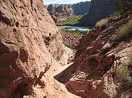
Somehow I made it! But No Way am I returning! Going down would be even more terrifying! Life is good. I want to keep it that way.
After that adrenaline rush, I peer down over the scary edge. Then taking a deep breath, I settle down enough to appreciate the scenery, especially when framed by a crack in the wall – a looking glass view of the fast moving current of the Colorado River - the golden cottonwoods along Kane Creek - the extensive towering domes – and the lightly snow-dusted La Sal Mountains.
From now on, it’s an easy ascent from one level to the next through high desert gardens of prickly pear, snakeweed, rabbitbrush, junipers, blackbrush, Mormon tea, squawbush, singleleaf ash and scrub oak. Every gain in elevation slowly opens the door for a tremendous change in viewpoint. Now miles beyond the river corridor, I can appreciate the magnitude of Behind The Rocks – a jumbled geological demonstration of piercing upright domes and fins, which contrast dramatically with the sparkling silhouette of the La Sal Mountains. 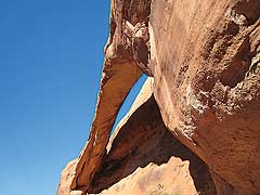
Arriving at an unsigned junction, I go right to stay on the trail to Longbow Arch, as it leads me in to a huge box canyon. The turquoise dashes, cairns (piles of rocks), and footprints continue to guide me to a side canyon where – at last – way up there – I see a winner of an arch. The scrambling on this primitive trail is minimal, and before long I’m perched underneath a marvelous opening to the sky.
Only the perfect recipe builds an arch. First start with a big sandstone fin. Then wait while the water seeps into the cracks and collects at the weaker points. As time marches on, a chemical reaction between the water and the rock breaks down the natural silica cement that holds everything together. In the meantime rock particles begin to slough off while the relentless cycle of freezing and thawing creates a pressure so powerful it acts like a sledgehammer until larger chunks eventually fall out. After a while an opening appears. Gradually it enlarges and then, a million years later, it’s done – the 60-foot span of Longbow Arch.
 I find a shady spot at its base and lean back on its rough, sandpapered texture. This tranquil sanctuary is solely mine to embrace as I feel the eternity of geologic time. Craning my neck I can see with its long span how this arch got its name – a bow of stone that is 60 feet long that only allows a sliver of blue sky to break through between it and the wall behind. Feeling drowsy I close my eyes and listen to the soft murmur of a breeze, the booming voice of a raven, and the raucous call of a scrub jay. I find a shady spot at its base and lean back on its rough, sandpapered texture. This tranquil sanctuary is solely mine to embrace as I feel the eternity of geologic time. Craning my neck I can see with its long span how this arch got its name – a bow of stone that is 60 feet long that only allows a sliver of blue sky to break through between it and the wall behind. Feeling drowsy I close my eyes and listen to the soft murmur of a breeze, the booming voice of a raven, and the raucous call of a scrub jay.
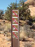
Ah this feels so good, but alas the time has come to move on. Retracing my footsteps to the unsigned junction, I go right for an easy cruise to the Poison Spider trail with a “no bikes or motorized vehicles” sign the only indication for the Longbow Arch trail. Now I’m home free to practically fly down this jeep trail grateful, after approximately 3.5 rugged round trip miles, to be safely back at the trailhead.
|