The La Sal Mountains, the second highest range in Utah after the Uintas, boast twelve peaks over 12,000 feet. Viewed from Moab and Spanish Valley, the most prominent and alluring of them all with its distinctive triangular shape is Mt. Tukuhnikivatz. At 12,482 feet it is the third highest in the range. Legend suggests that Tukuhnikivatz is a combination of Native American words that mean, “where the sun lingers longest” – an appropriate term for a unique landmark that enchants first time visitors. As for locals like me, it’s a natural part of where we live and on a clear day its mesmerizing image greets me first thing in the morning. In the winter I am often caught up in that magical moment when storm clouds lift to reveal this mystic mountain decked out with a fresh layer of pure-white snow. 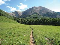
Now for some important news: A trail has recently been constructed that goes up to the southern ridgeline of this rugged peak. After reaching the ridge, however, you are on your own to scramble through that slide-away-rock known as scree to the top.
To access the trailhead drive south from Moab on Highway 191approximately 22 miles and turn left at the sign for the town of La Sal. Then drive another 13 miles and take a left on to the Upper Two Mile graveled dirt road. In two more miles make another left turn for the La Sal Pass Road and drive six more miles to the La Sal Pass parking area. This graveled road with one stream crossing to the pass (a total of nine miles) is suitable for most two-wheel-drive vehicles. Beyond that, however, it turns in to an extreme four-wheel-drive road down to Pack Creek Ranch. Various people who have taken it have told me they’d never do that again!
Even up here it gets warm, but I’m immediately putting on my shirt as a protection against the mosquitoes and flies. Then just beyond the parking area as I start on the Burl Friends trail - there they are – a fabulous view of both Mt. Tukuhnikivatz (also known as Tuk) and Mt. Peale. Peale, the highest at 12,721feet, is named after Albert Charles Peale, a geologist on the Hayden Survey team in 1875. 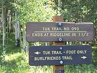
Right away I’m traipsing through the lushness of an enticing meadow. Lots of moisture has created a greenbelt filled with a splashy bouquet of wildflowers - a feast of nectar that attracts the graceful elegance of chocolate-brown butterflies.
After walking a half-mile I reach a signed junction and take a left for the Tuk trail #093 - foot traffic only with mileage of 1.5 miles. While embracing the welcome canopied shade of a grove of aspens, I now notice that the trail begins to climb in earnest. Advancing through the thickness of deep woods I relish the fresh scent of pine, the trickling flow of a small stream, the loveliness of wild geraniums, bluebells, and white violets, while chickadees chatter their trademark “chick-a-dee-dee” call. Along the way a doe and her twin fawns peek out at me. Both tentative and curious she tiptoes around for a better look at my intrusion before the whole family goes bopping back in to the trees.
Too soon, however, I’m leaving this haven of cool refreshment to return to wide-open vistas and the familiar profiles of Tuk and Peale. Before long I’m crossing a steep slope replete with the fiery brilliance of scarlet gilia flowers. Then wandering past a watering trough and an old fence encasing a spring, the trail swings left in a westerly direction through another meadow. Off in the distance several vocal robins urgently call back and forth making me wonder if they are asking each other, “Where are you?”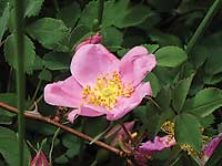
At the first of many switchbacks I stop to absorb the appealing rural scene of Old La Sal below and the vast stretch of old time ranches. A high-altitude garden of flowers delights me as I stroll by a mixture of lavender showy daisies, purple Whipple pentstemon, golden pea, blue flax, Indian paintbrush, wild roses and the exquisite sego lilies. Continuing on a short passage through a gully lands me into dense firs that are swaying in a cradle-rocking breeze. For whatever reason this always reminds me of sleeping in a tent.
I am excited when I catch sight of a ridge up ahead, only to be disappointed when I reach it. It is just an illusion - the final ridge lies ahead up there somewhere. By now the elevation is killing me as I ponder the question - How many more switchbacks can there possibly be? Determined to find out I keep pushing on and on until the trail ends at a big pile of rocks surrounding a big stick. But since I’ve come this far, I’m not ready to quit yet and stubbornly I struggle on cross-country for another half-mile. Finally at almost 12,000 feet – at last - I have obtained my goal – the ridge that connects Tuk to Peale with an in depth look down in to the rich green belly of Gold Basin.
 The summit of Tuk now appears temptingly attainable, but I climbed Tuk with all its loose rock many years ago - that’s good enough for me! Instead the breathless (literally) view from here suits me just fine. From this windswept ridge I can see all the way to Colorado including the San Juans and Sleeping Ute Mtn. Then coming back to Utah: I am gazing at the Abajos to the southeast, the Henrys directly to the west and the Bookcliffs on the far distant northern horizon. Closer to my own turf of well known peaks, I have a full circle panorama of Peale, Tuk, Tuk No, Laurel, Mellenthein, Haystack, Manns, Pilot, Green and Gold Knob. What’s more there’s Pre-Laurel and with binoculars I can even make out the weather station on it. The summit of Tuk now appears temptingly attainable, but I climbed Tuk with all its loose rock many years ago - that’s good enough for me! Instead the breathless (literally) view from here suits me just fine. From this windswept ridge I can see all the way to Colorado including the San Juans and Sleeping Ute Mtn. Then coming back to Utah: I am gazing at the Abajos to the southeast, the Henrys directly to the west and the Bookcliffs on the far distant northern horizon. Closer to my own turf of well known peaks, I have a full circle panorama of Peale, Tuk, Tuk No, Laurel, Mellenthein, Haystack, Manns, Pilot, Green and Gold Knob. What’s more there’s Pre-Laurel and with binoculars I can even make out the weather station on it.
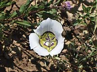
After awhile I turn my attention to the precious beauty of the tundra flowers. Above timberline only the strong survive these harsh conditions and I admire their ground hugging tenacity. How can these small delicate looking plants possibly do it: the saxifrage, moss campion, sky pilot and alpine sunflowers?
Finally peering down on Medicine Lake and La Sal Pass – wow - I suddenly realize how far I’ve come - 3.5 miles with an elevation gain of almost 2,000 feet. I’m so happy I made it to this top-of-the-world view – a rewarding workout that guarantees a good night’s sleep!.
|