My day begrudgingly begins at dawn with a quick hop out of bed. Immediately the rush is on: a quick breakfast – a last minute check of my gear – a charge out the door – and a not-wasting-any-time drive to the high country. Afternoon thunderstorms are in the forecast so the race is on to complete my 3.5-mile loop hike in Pole and Doe Canyons before they become too threatening.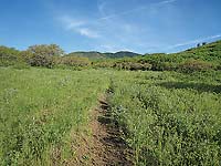
A prominent landmark on the Old Spanish Trail, the name “La Sal” was originally recorded in the 1776 journals of Dominquez and Escalante - two friars on an expedition to find a route to connect the Catholic missions in California and New Mexico. Their Ute guides had referred to them as the “Sierra de la Sal,” meaning The Salt Mountains.
Turning the calendar back to the 1800s, stockmen grazed their sheep and cattle here, a practice that continues. Mining and limited logging also occurred. Now most people come here for recreation – hiking, hunting, horseback riding, fishing and mountain biking in the summer and fall – snowshoeing, skiing, sledding and snowmobiling in the winter.
The formation of the La Sals occurred twenty-five to twenty-eight million years ago when an intrusive molten magma created an uplift of 6,000 feet and cooled into igneous rock. Then the overlying, less resistant sandstone eroded away leaving behind the mountains we see today. With at least twelve peaks over 12,000 feet, they comprise the second highest range in Utah after the Uintas, and are categorized into three distinct groups – north, middle and south. 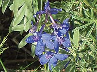
Pole and Doe Canyons are located in the foothills of South Mountain. To get there drive south of town on Highway 191 approximately 22 miles and turn left at the sign for the town of La Sal. Drive another 13 miles and take a left onto the Upper Two Mile graveled dirt road. In two more miles make another left turn for the La Sal Pass Road. Then drive 1.2 miles and look for the unsigned left turn on to Forest Service Road 128 (also known as the Deer Springs Road). You’ll find the trailhead for Doe Canyon in half a mile with the trailhead for Pole Canyon another 1.2 miles beyond that. This rough two-wheel drive route is do-able for most high clearance vehicles as long as the road is dry.
Just before that final turn I have to stop. There’s no way I’m going to pass up this fabulous view of Mt. Peale and Tukunikivatz Peak. Mt. Peale, the highest at 12,721 feet, was named after Albert Charles Peale, a geologist on the Hayden Survey team in 1875. Tradition suggests that the Ute translation of “Tukunikivatz” means place where the sun lingers longest, an appropriate term for one of our more impressively shaped peaks.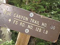
I start my hike at the Pole Canyon trailhead. The oaks interspersed with lush meadows brim with the dashing colors of cutleaf daisies, larkspur, pink phlox and dandelions. An upset chipmunk squeals his annoyance at my presence. The crickets, however, couldn’t care less that I am here. They never miss a beat in their haunting tune as the warbling vireos add their boisterous song to the mix.
Sometimes in the grassy areas the trail disappears for a short distance, but I easily pick it up again. Then after an extended uphill grunt – at last - I reach the refreshing shade of aspen trees and the portal of Pole Canyon, where chill waters flow and the raspberry, strawberry, Oregon grape and chokecherry plants grow.
Eventually I pass through the opening of a barbed wire fence and continue upward until the trail seems to disappear in a meadow. Swinging left, however, next to an abandoned watering trough I quickly pick out a trail marker. Immediately after that, I reach a marked junction. This is where I swing right to start the Doe Canyon Trail rather than proceed straight for 1.3 miles to connect with the South Mountain Trail. I have already covered 1.7 miles with 1.8 more to go. Mileage-wise I’m half way there, but more uphill still lies ahead! That realization takes the wind out of my sails and I plop down for a snack, pick-me-up break on the leaf littered ground under the straight-and-tall, white-barked aspens and the thickly branched firs.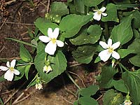
Once refreshed and ready to march on, I head in an easterly direction on this minimally used trail that can be hard to follow. Wiggling over logs, I press on. As I gain more elevation another marker appears. Then at 9500 feet – phew – I’ve made it to the ridge between Pole and Doe where the more level terrain is edged by a big grove of leaf-tossed aspens. Now two piles of rocks keep me on track. Going through a cattle allotment gate another marker indicates the route. A few steps more - and wow! – a fantastic view awaits my perusal including the Abajos, Sleeping Ute Mountain in Colorado and a wide swath of ranchlands.
After that the trail steeply projectiles down through the aspens, lush green grass, columbines ready to burst into bloom, bright yellow banner pea flowers, and shy white violets. A black-tipped white butterfly joins a mourning cloak butterfly and swallowtails to add a delightful pizazz to this woodland walk.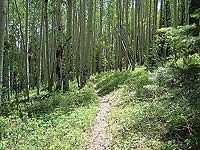
Before long a log across the trail sends out the message: sit down on me, take a load off your feet and enjoy this shady spot for a while. I readily accept this enchanting, filled-with-music invitation as the lyrical flute-song of the Hermit thrush, the strong conversation between two ravens, the “cheese-bur-ger” mating call of the mountain chickadee, and the trumpety voice of the red-breasted nuthatch resonate through the trees.
Ah, this is pure contentment until suddenly I notice the clear skies of morning have turned into afternoon clouds of warning - a strong indication I need to stop lollygagging around. Reluctantly I move along. When I reach the oaks, however, the breeze dies down, the clouds mosey along, and the deep shaded canopy is gone. Now I’m drooping from the radiant warmth of a summer’s day. So at trail’s end, when my husband meets me with a cold beer, I’m thinking - All Right! Who could ask for anything more to wrap up this vigorously successful hike that involved an elevation gain of at least 1200 feet!