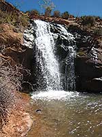
Life is full of surprises; a visitor’s first vision of Ken’s Lake and Faux Falls is one of them. Since this unexpected oasis seems out of place in the middle of an arid environment, the question could be asked – Where does all this sudden emergence of water come from? The answer is Mill Creek, a stream originating in the higher elevations of the La Sal Mountains at Burro Pass. When it drops down out of the high country, a portion of its flow is diverted through Sheley’s Tunnel, which is followed by the torrential 645-foot cascade of Faux Falls. After that it’s the final dash on a clear, fast moving stream to Ken’s Lake.
 Building a tunnel, however, did not come easy. Horace Sheley attempted it in the early 1900s, but failed when he couldn’t bore through the entire length of sandstone. Consequently the project languished for decades. Then in the 1970s a cycle of drought pressed the need for more water, which triggered a renewed interest in its completion.
Ken McDougald, a former mayor and water conservancy district chairman, labored for 15 years to plan and build this reservoir. This ambitious endeavour (the Mill Creek Project) cost four million dollars – an enterprise funded by General Obligation Bonds that were issued by the Utah Division of Water Resources. It also included a pressurized water delivery system, a one million gallon drinking water storage tank, and the development of a culinary production well. Ground breaking began on October 4, 1979, and dedication took place on June 5, 1981 - a project developed mainly for irrigation purposes in upper Spanish Valley, long known as Poverty Flats because of its serious lack of water.
Stocked by the Utah Division of Wildlife, brown and rainbow trout thrive in the lake’s maximum depth of 70 feet. Since motorized craft are allowed only for trolling, anglers, swimmers, and boaters come here to enjoy a tranquil interlude. When the lake freezes over, ice skating is a popular activity, and year round birdwatchers look for the latest arrivals – ducks, geese, mergansers, shorebirds, osprey, bald eagle, etc. 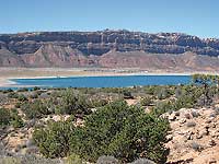
To get to Ken’s Lake, from Moab go south on Highway 191 approximately 7.5 miles and turn left at the sign for the Ken’s Lake-La Sal Loop Road. Then continue to the stop sign and turn right. After driving about 1.4 miles, turn left on the Ken’s Lake-Flat Pass Road, and then turn left at the sign for Ken’s Lake.
The Ken’s Lake Recreation Area includes three hiking trails - the Lake Loop, Faux Falls, and the Rock Loop, which offers an interesting circle around a large outcrop of Navajo Sandstone called “The Rock.” Early on April 1st, a clear, calm morning greets me upon my arrival at the lake. All right, it looks like a great day for bird watching – a good one for a hike around “The Rock.” Hungrily soaking in the warmth of the sun, I’m having a fun time identifying the birds – goldeneyes, common mergansers, bufflehead, ring-necked ducks, cinnamon teal, ruddy ducks, great blue heron, an osprey, and a Cooper’s hawk.
Then unexpectedly on this April Fool’s Day, a raging north wind barges in creating the inevitable bouncing of the whitecaps, the insistent crashing of waves on the beach. What a shock to hastily be putting on more layers, but at least since I’m wearing everything I brought, my pack is much lighter! In the midst of this unexpected tempest I’m tempted to bag it. Instead I stubbornly press on with the hope this gale force is only temporary as I leave the parking area to mosey along heading east on the Ken’s Lake Inlet Trail 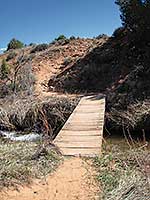 – a very short, well-used path that connects the lake to the campground. Along the way the eye-catching scenery halts me in my tracks. The saw-toothed profile of Behind The Rocks and the alluring alpine grandeur of South Mountain, Mtn. Tukunikivatz and Tuk No definitely deserve an appreciative pause.
At the campground I go left to continue walking in an easterly direction past the campground host’s trailer until I reach the trailhead, which is directly across from group site B and just beyond campsite # 24. Immediately the trail drops down to a wooden bridge and crosses the stream that goes to Ken’s Lake. The weathered sign at the first junction is almost unreadable, but with “The Rock” straight ahead as my guide, it is obvious I should go straight on the rock-lined trail, rather than right for Faux Falls. Then at the next junction I choose to turn left in order to go in a rare-for-me counterclockwise direction so I can see this roundabout trail from a different perspective. In places the signage is confusing, but by following the more distinctive path that continues toward The Rock I manage to stay on course. At the top of the loop this lightly used route completely disappears, but not for long. After a little searching I’m back on track again.
Totally windblown I want a break, and what a relief to hunker down behind the protective branches of pinyons and junipers as I gaze down on the deep blueness of the lake and the upper reaches of Spanish Valley. Since few people come this way, it makes this spot feel like a secret hide away as I watch a cottontail scampering away in to the blackbrush and Mormon tea.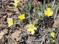
Once that refreshing stop is over, despite a restless wind, I see Faux Falls off in the distance and can’t resist the urge to extend my hike. Two signed left turns later I’m now walking on the main trail along the creek – a route lined with cottonwoods, willows and other water loving vegetation. Here I finally find the first wildflowers of spring: petite yellow Newberry’s twinpod, flaming orange-red Indian paintbrush, and delicately shaped showy stoneseed.
“Faux” is French for “false” or “fake,” but Faux Falls has always felt real enough to me. Upon my arrival the roaring surge is overpowering as I watch this rush-of-water-on-steroids free falling into the pool creating a splash that swirls around like a washing machine. Who can resist this mesmerizing show? Certainly not me, and plopping down I watch the endless streaming of energy and motion. When I look upward – ah ha – there they are – white-throated swifts, the speed demons of the sky back from their winter vacation in Mexico and Central America.
Much later I reluctantly walk away from this out-of-the-breezes sanctuary with its magical performance to return to the bridge, the campground and the welcome shelter of my car!