 On each bend of the ledgy, rock-hopping switchbacks, known as Barney Rubble, I’m always surprised at the gain in elevation, always dazzled by the poetic outline of the La Sals now heavily mantled with fresh snow. When the switchbacks end – there it is – the elusive opening to Hidden Valley - a 1.3-mile stretch of grassland and scattered junipers. Bordered on the southwest side by massive Wingate Sandstone walls, the name speaks for itself. Sequestered within a broken arm of rocky cliffs, this secretive spot evades detection until I practically stumble upon its entrance.
How long has this ancient trail been used? No one knows for sure, but the first evidence of a prehistoric people in southeast Utah can be traced back to around 6,000 B.C. Constantly on the move, these bands of hunter/gatherers, known as the Desert Archaic, left little behind of their legacy except the prolific rock art pecked and painted on sandstone canyon walls.
The Basketmakers replaced or evolved from the Archaic around 0 A. D. Their domain as a semi-agrarian society lasted 800 to 900 years. Their scattered dwellings and most of the rock art on the panels in Hidden Valley are associated with them. It has been speculated that this area was a social and ritual center – a popular and convenient gathering place for these prehistoric people.
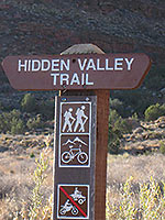
 On this crisp fall day in early November, my six-mile hike starts at the Hidden Valley trailhead. Passing through various sections of Behind The Rocks Wilderness Study Area, which encompasses 12,635 acres, my walk will finally end at the Moab Rim trailhead.
After gaining 680 feet, the switchbacks spit me out on more level ground. Plopping down on a high-ended platform near the beginning of Hidden Valley, I grab this opportunity to catch my breath while savoring a bird’s eye gander at the familiar landmarks in Spanish Valley: Spanish Trail Arena, White’s Ranch, Spanish Valley Drive and the Moab golf course.
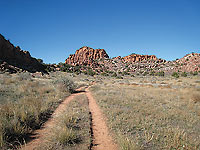
Intently I soak in the quilted green fields of alfalfa and the golden autumn patchwork colors of cottonwoods below. Once I’m up and moving along Hidden Valley invitingly stretches ahead with a wide, gentle-on-the-feet dirt path that gradually turns into a two-track route.
 As I stroll along, the ringing “chuk-chuk-chuk” alarm calls of chukars are a dead give away that they are close by. Introduced from the Middle East, these chicken-sized, upland game birds, with a distinctively plumaged black necklace, thrive on the grassy, rocky hillsides. Usually secretive, they are more often heard than seen.
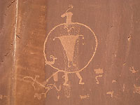
At approximately 5,275 feet, an obvious hump, the mini pass marks the end of Hidden Valley and the beginning of the Moab Rim Trail. At this point I veer right on a distinctive footpath – a short trail that goes to the south facing rock art panels where walls of Navajo Sandstone overflow with fascinating petroglyphs: outlines of deer, animal tracks, odd shaped human figures, long lines of hand holders, tribal head dresses, hand and foot impressions, necklaces, symmetrical lines and dots, cat-like depictions, and plenty of bighorn sheep.
While studying these wildly imaginative figures, many questions fly through my mind: Who were these artists? - Why so many drawings? – Was it recreational, religious or strictly to pass on news and information? What did these people look like? How long did they inhabit this area? What ceremonies did they perform? Did they have a routine in their daily lives? And at that time, what did this place look like? So many questions – so few solid answers. Most of its history has been lost in the shifting sands of time.
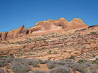 When this petrographic art show plays out, I backtrack to the pass and drop down to the Moab Rim Trail - a further extension of the Hidden Valley trail for about a mile until it turns into a well-used jeep trail. Before long – oh wow - the field of vision changes with an expansive view of Poison Spider and the Golden Spike Mesas. Beyond that Dead Horse Point and Island In The Sky are poised on far distant ridgelines. And directly ahead a run-on series of fins and cliffs spectacularly rise above the mesa floor.
Over the slickrock, cairns (piles of rock) guide the way. Covering more ground, footprints and various signs keep me from straying off the main course. Eventually, at a major fork, a decision must be made – go right for the Sandy Hill route, which travels down an extremely sandy drainage, or continue straight for higher, more stable ground.
I opt to skip Sandy Hill. Moving straight ahead white painted stripes repeatedly lead me up and down domes and walls of slickrock, until I finally reach the other junction for the Sandy Hill Road. Not long after that I recognize a series of deep potholes I must skirt around.
Climbing higher, the vistas constantly change. First the La Sal Mountains pop up on the southeastern horizon. Then “The Windows” in Arches National Park flaunt their distinctive silhouette. Soon after that, I have a wide-angle view of the entire town of Moab.
 Upon reaching the rim’s apex, I bear left for the unrelenting descent on the Stair Master, a fairly new hiking trail. This route received its name because it climbs at a heart-thumping rate of 1,000 feet in approximately one mile. Near the top the grade is an unrelenting 25%! Paralleling the jeepers’ route, it wraps under sheer cliffs of Navajo Sandstone along the northeastern boundary of the Wilderness Study Area.
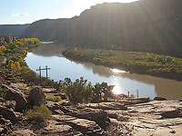
Fortunately I’m going down, but oh my, that’s hard on the knees, legs and toes! As the momentum pushes me along, the impressive image of the Portal Dome appears along side a huge indentation that I refer to as “The Notch.” When I see the far stretching flow of the Colorado River, I know I’m closing in on home base, and before long I’m crossing the finish line at the Moab Rim trailhead where my intriguing six-mile journey ends.
To arrange a shuttle go south on Main Street and turn right at McDonald’s on to Kane Creek Blvd. At the stop sign continue straight for two miles, and just past the cattle guard turn left into the parking area. Leave one vehicle here, and retrace your route to McDonald’s. Then turn right on to Highway 191 and drive three miles. At the stucco dental office turn right on to Angel Rock Road. When it ends, go right again on to Rimrock Road for the short distance to the trailhead.