 With the nation gripped by the Great Depression, Franklin D. Roosevelt proposed the Civilian Conservation Corps (CCC) – a five year program that provided three million jobs for the conservation and development of our natural resources. Consequently in the spring of 1933, a CCC camp was established at the Warner Ranger Station. In one season almost 200 men completed range improvements, overhauled trails and roads, dug lengthy water diversion ditches and rebuilt part of the La Sal Loop road. They also constructed the stream-fed reservoirs of Medicine, Oowah and Clark and rebuilt Warner. These projects, especially our beautiful alpine lakes, have now become an integral part of the La Sal Mountains. It’s hard to imagine all the strenuous work involved in their construction, and even harder to picture our alpine landscape without them.
Many trails eventually lead to Clark Lake, but since they are all non-motorized it is usually a more tranquil, less crowded lakeside experience than other drive-in lakes. The shortest and easiest route - Clark Lake Trail # 141 – can be accessed from the Geyser Pass Road, 8/10ths of a mile beyond the Gold Basin turn off. After the cattle guard look for the trailhead sign on the left. 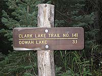
To get to the Geyser Pass Road, drive south of Moab on Highway 191 for eight miles out of Moab. Take the left turn for Ken’s Lake, go to the stop sign and than take a right on Spanish Valley Drive, which turns into the La Sal Loop Road. Approximately 12 miles from town, turn right on to the Geyser Pass Road .
On this moody-sky morning I grab my pack and enter the pungent earthy dampness of firs and spruce. I have ambitious plans for this iffy, melancholy day - a 5.5 mile hike that eventually ends up at the Squaw Springs trailhead. Even though I have raingear, a walk in the rain is not my favorite activity, which at the moment is a strong possibility. But since my shuttle driver has departed, there’s no turning back now!
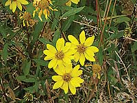
Before long the forested thickness gives way to a light-hearted meadow - a tapestry of white clover, yarrow and showy daisies where once upon a time someone obviously lived. Poking around, I find scattered boards, bedsprings, pieces of metal and glass, rusty cans, parts of a stove and several posts from an old corral. Nearby several rustic tables linger within an old campsite. As I search through these leftovers from a bygone era, I keep wondering – Who lived here and what story would they have to tell?
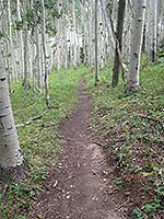 Back on the trail it’s a sharp descent to an easy-going creek with a flattened log that provides a sure-footed crossing. Soon after that, I’ve reached the signed junction for the Moonlight Meadows Trail. To reach Clark Lake I go left for a pleasurable stroll through a series of flower-filled meadows. Now the rounded hump of Haystack Mountain, elevation 11,641 feet, is a steady vision with a its distinctive image of stunted trees that extend almost to its summit.
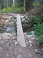
Before long a wooden plank insures a “piece of cake” crossing over the next stream. The gradual descent continues through a mixture of firs, spruce and aspens interspersed with a steady procession of meadows to the last stream crossing, which is easily crossed by a series of flat rocks.
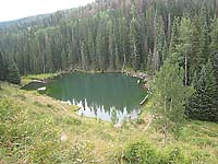
Eventually a small creek, the source of Clark Lake, lies directly below where a rush of water produces a wealth of wildflowers. Then at the end of a 1.2 mile descent, I am gazing at the lake’s picturesque emerald-tinged waters.
At the yellow cattle guard I wander down the short, eroded path to its quiet shore - a perfect spot for a long break. So far so good - despite the forecast, no rain yet! Above me I study a steep slope where aspens, firs and spruce desperately cling to unsteady ground. With the wide girth of Haystack Mountain in the background, the small fry fish are jumping - a chipmunk eyes my munchies – and chickadees voice their trademark calls.
 This idyllic setting is hard to leave, but I can’t dally for long, so with a sigh I slowly gear up for the rest of my walk. Heading over to the sign for Oowah Lake I pick up the Horse Gate Trail where a brightly colored meadow is engorged with a delightful bouquet of yarrow, yellow daisies and lavender asters having their final end-of-summer fling.
In half a mile I’ve connected with the main trail to Oowah when suddenly a burst of wings startles me. A dusky grouse has flushed and flies a short distance into a tree where with soft mumblings he ponders the best course of action – hold tight or take off. When I leave he’s still thinking it over.
The descent to Oowah is a gritty, hard-to-stay-on-your feet drop. Cautiously down, down, down I go until at last there’s that small body of water peeking out from its wooded banks. Crossing the wooden plank bridge puts me lakeside with the amenities of picnic tables, two outhouses and 11 campsites. Then on the other side of Oowah’s earthen dam the upward grind to Boren Mesa begins through the shrouded embrace of firs and the enchanting waltz of the quaking aspens. At a major junction the sign has fallen to the ground; I continue straight to stay on the Boren Mesa Trail #037 rather than go left, which proceeds back to Clark Lake.
 After passing by Forest Service Road 4686 - a one mile jeep route to the main road - I reach the wide-open back of Boren Mesa, which is named after Carl Boren, a cattleman who settled in this area in 1876. Now at an elevation of 9300 feet my efforts are rewarded with a spectacular view of Spanish Valley and the rugged outline of Behind The Rocks. Beyond that there are miles and miles of an expansive landscape – a tangled web of canyons, mesas and buttes clear to the Henry Mountains. Then I zoom in to the home turf of the La Sals – those familiar peaks of Tukuhnikivatz, Tuk No, Laurel, Mellenthin, Haystack, Pilot and Gold Knob.
When the trail drops off the mesa it cruises down a dryer slope where the oaks thrive - a long, steep drop to Horse Creek and its delightful haven of splashing water. After that it’s a gentler trail to the trailhead just ahead of the first drops of rain!
I’ll continue to enjoy the flavor of fall in the high country through the end of October. But after that, as the snow starts to fly, I’ll be moving my hiking agenda to the lower elevations of our fabulous canyonland country.