 Yes, the rumor is true; there is a new trail to the top of Manns Peak. But with the double whammy of high elevation and a steady steep grade, this is still a hike not to be taken lightly. Consequently I am having serious thoughts about how much further I really want to go on this brilliantly clear, blue-sky morning in mid-June! Conditions, however, don’t get much better than this, and with no reasonable excuse for turning back I keep on trucking. If I make it, I will have climbed a grand total of 1,772 feet!
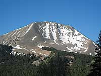
At 12,272 feet, Manns Peak is the 5th highest in the La Sals - a mountain range formed 25 to 28 million years ago when intrusive molten magma cooled into igneous rock. Over time successive intrusions pushed the overlying sediments up as much as 6,000 feet, forming the mountains that we see today!
 Turning the calendar back to the 1800s, this alpine area was used for grazing sheep and cattle, a practice that continues. Mining and limited logging also occurred. Now most people come here to recreate – hiking, horseback riding, fishing and mountain biking in the summer and fall – snowshoeing, skiing, sledding and snowmobiling in the winter.
A prominent landmark on the Old Spanish Trail, the name “La Sal” was originally recorded in the 1776 journals of Dominquez and Escalante - two friars on an expedition to find a route to connect the Catholic missions in California and New Mexico. Their Ute guides had referred to them as the “Sierra de la Sal,” meaning The Salt Mountains for the salt deposits at its base.
My day starts at 5:30am with a begrudging hop out of bed. After that, the rush is on - a quick breakfast – a last minute check of my gear – and then, grabbing my pack, I’m out the door for the sun-in-my-eyes cruise to the high country. If my luck holds out I’ll have ample time to make this climb, and my early arrival gives me a better shot for a leisurely hike to the top.
 The shortest route for climbing Manns Peak starts at the Burro Pass trailhead. To get there from Moab go south on Highway 191 for approximately eight miles before turning left at the sign for the Ken’s Lake-La Sal Loop Road. Then go right on to Spanish Valley Drive, which quickly becomes the La Sal Loop Road. After driving approximately 12 miles take a right turn on to the graveled Geyser Pass Road, which despite the washboard is suitable for any vehicle. Then drive eight more miles to Geyser Pass, which has nothing to do with any geothermal activity. Instead, it is named after the early cattleman, Al Geyser.
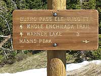
Not far beyond Geyser Pass, a sign marks a fork in the road – right to Dark Canyon and Highway 46, left for the Burro Pass trailhead. Drive 1.2 miles on the left fork and look for the left turn to Burro Pass, where a high clearance four-wheel drive is essential for this half-mile section that takes you to the trailhead.
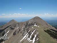
Before hitting the trail I pause to admire the southern view - a commanding presence of the two highest peaks in the La Sals. At 12,721feet Mount Peale ranks first and Mount Mellenthein – 12,645 feet high - comes in a close second. Way beyond these prominent landmarks, the San Juan Mountains in Colorado cast their dreamy profiles against a hazy, far distant horizon.
The trail, at 10,500 feet in elevation, officially begins at a bright yellow cattle guard. From here it is a mile to Burro Pass, and 4.5 miles to Warner Lake. This is also the starting point for the Whole Enchilada, a popular mountain bike trail, which runs a 25 mile course to the Colorado River – a vertical drop of 7,000 feet.
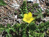
Right away I am relishing the shaded relief of aspens, firs and spruce - the refreshing music of a gentle stream - and spacious meadows overflowing with the early season wildflowers: dandelions, wild parsley and buttercups. Naturally, as an avid bird watcher, I’m tuning in to the enchanting chorus of birds: raucous pine siskins, perky ruby-crowned kinglets, twilling juncos, cheery-voiced robins and the flute maker himself – the Hermit thrush.
With a view of Mount Tomasaki to my right and Manns Peak straight ahead, I forge on. Then on a short series of switchbacks, which are bringing me close to the pass, piercing shrieks shatter the peaceful atmosphere. Searching the rocky slope above I am stunned to witness a bizarre event – two marmots fighting over a small carcass!
 Soon after that - Phew, I’ve made it to the pass. At 11,150 feet no wonder I’m feeling breathless! With one mile now under my belt, I still have another one to go! Unfortunately, the steady increase in elevation is going to slow me down tremendously! Watching a golden eagle I envy his seemingly effortless flight. He could easily cover the distance in a matter of minutes versus my hours!
At the sign for Manns Peak I go right and continue up the ridge. Step by slow step I gain ground and leave the big trees behind. Gradually I reach the tundra with its treasure house of flowers – moss campion, cinquefoil and sky pilot.
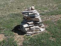
Eventually stone monuments leave no question as to the best route through the rock-strewn scree to the summit. For a while I’m even walking up a staircase of rocks! By now the summit is tangibly visible, but discouragingly still seems so far away. Feeling like a slug, I creep along wondering - am I ever going to get there?
Then finally it happens. Yeah, I have reached the top of Manns Peak! My heavy pack hits the ground with a thud. What a relief to plop down for an extensive break!
 At last I can reap the rewards of a spectacular panoramic scene – on the far horizon there’s the Henry Mountains, the Bookcliffs and the Abajos. I can pick out Castle Valley, Porcupine Rim, Moab and Behind The Rocks. Then turning my attention to the familiar peaks in the La Sals I soak in the prominent presence of Tuk No, Tukuhnikivatz, Mellenthein, Peale, Haystack, Tomasaki, Pilot, Green and Waas.
Bagging this summit brings on a euphoric rush - I am thrilled and so proud that the hard workout has paid off. Now I can relax and savor this Top Of The World vista knowing the difficult part is over. From now on it’s downhill all the way back!