I have arrived at the lake ahead of the dawning of a new day, and in the waning twilight what do my wondering eyes see – the ghostly appearance of three white birds flying across the water. Plopping down on the sandy beach I patiently wait as the sun’s rays illuminate the ragged outline of Behind The Rocks. Stealthily the radiance crawls down the sheer-edged wall below. Slowly it creeps across the valley floor until suddenly I’m bathed in the welcome warmth of dazzling sunshine – a wake-up call for the meadowlarks who burst in to a bubbling flutelike chorus. Now in the light of day, identification is finally at hand, and I am flabbergasted to discover that the mystery birds turn out to be ring-billed gulls! – rare migrants in this part of the world.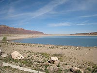
Ken’s Lake, a man-made surprise, just happens to be located smack dab in the middle of a dry, redrock environment - a sharp contrast of deep blue water against a surrounding arid landscape – an oasis that attracts a lot of birds – an ideal place for swimmers, anglers and birdwatchers, especially during the spring and fall migration.
Around the beginning of the twentieth century Horace Sheley attempted to construct a diversion tunnel near Flat Pass to divert water from Mill Creek. He, however, was unsuccessful in boring through the sandstone, and the project languished for decades until the early 1970’s when a cycle of drought pressed the need for more water.
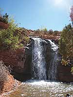 After years of planning ground breaking began on October 4, 1979. Dedicated on June 5, 1981, the lake was named for Ken McDougald, a former mayor of Moab. As the water conservancy district chairman he passionately worked on this endeavour - an enterprise developed mainly for irrigation purposes (the earthen dam holds an estimated 2,750 acre feet of water) in upper Spanish Valley, long known as Poverty Flats because of its serious lack of water. The water emerging out of the tunnel falls in a torrential rush over boulders and rock ledges with a wild drop down Faux Falls followed by the final mad dash to the lake.
To get to Ken’s Lake from Moab go south on Highway 191 approximately 7.5 miles and turn left at the sign for the Ken’s Lake-La Sal Loop Road. Then continue to the stop sign and turn right. After driving about 1.4 miles, turn left on the Ken’s Lake-Flat Pass Road and follow the sign to Ken’s Lake.
With so much birding activity at the lake - gadwalls, cinnamon teal, shovelers, ring-necked ducks, common mergansers and a killdeer - it takes a while before I’m willing to budge for my hike to Faux Falls. But since the day is still young, I have no desire to rush; moseying along on the Ken’s Lake Inlet Trail the eye-catching scenery halts me in my tracks. The saw-toothed profile of Behind The Rocks and the alluring alpine grandeur of South Mountain, Mtn. Tukunikivatz and Tuk No definitely deserve an appreciative stop.
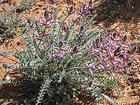
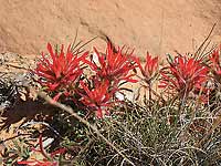 This extremely short path ends at the BLM (Bureau Of Land Management) campground where I decide to try a new-to-me route, which starts at the sign just past campsite 31 following a dirt road for a very short distance. Then at another sign with two arrows I go left for a foot trail that clings closely to the south side of the creek with its lush growth of cottonwoods, willows and native water-loving plants. Now I’m constantly pausing to savor the first wildflowers of spring - the lovely lavender blossoms of vetch, the shy petite yellow blooms of the Newberry twinpod and the brilliant reddish color of the Indian paintbrush.
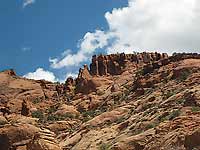
The dramatic scene on the eastern horizon also rivets my attention - a stunning parade of sandstone structures traveling in a north-south direction. If I could fly above them, I’d be looking down on Mill Creek. They flank both sides of Flat Pass, while another section of sheer cliffs stretches up almost to the edge of Johnson’s Up On Top - a massive concentration of gargantuan slabs of rocks, rocks and more rocks - a frenzy of wild contortions either tilted sideways, backwards or shooting straight up from the ground.
 “Faux” is French for “false” or “fake”, but Faux Falls has always felt real enough to me. Upon my arrival the roar is overwhelming as I watch this rush-of-water-on- steroids – so much motion, so much energy, so much super-charged power plunging in a tremendous free fall into a turbulent pool that swirls around like a washing machine.
At the top of this whirlpool the appearance of a dipper comes as no surprise. This chunky, slate gray bird is the only North American aquatic songbird that catches all its food by swimming or walking on fast-moving stream bottoms – an amazing feat to watch.
On this overly warm day I am grateful for a misty haven of coolness where only the frantic dash of water can be heard. Insulated from the outside world I contentedly watch this mesmerizing, constantly changing escapade go on and on. But alas the time comes when I must leave, and carefully I choose the best place to cross the creek - I definitely want to leave a dip in the creek to the dipper!
 As I walk away from the raucous rumble of water, the stunning silence is breached by the loud voices of two upset ravens harassing a red-tailed hawk who responds with a piercing call. Oh yes, it is that feisty time of year when a territory is fiercely protected.
It doesn’t take long an alternate trail on the north side leads me to a wooden bridge over the creek to the campground. Retracing my steps back to the lake completes a delightful loop enhanced by the cooling cascade of a waterfall - a wealth of wildflowers - the wonder of birds - a dynamic scene governed by a red rock landscape - and the snowy outline of the La Sal Mountains. Like a magnet I can’t resist this unique combination of water and desert that beckons and pulls me back again and again.

 After years of planning ground breaking began on October 4, 1979. Dedicated on June 5, 1981, the lake was named for Ken McDougald, a former mayor of Moab. As the water conservancy district chairman he passionately worked on this endeavour - an enterprise developed mainly for irrigation purposes (the earthen dam holds an estimated 2,750 acre feet of water) in upper Spanish Valley, long known as Poverty Flats because of its serious lack of water. The water emerging out of the tunnel falls in a torrential rush over boulders and rock ledges with a wild drop down Faux Falls followed by the final mad dash to the lake.
  This extremely short path ends at the BLM (Bureau Of Land Management) campground where I decide to try a new-to-me route, which starts at the sign just past campsite 31 following a dirt road for a very short distance. Then at another sign with two arrows I go left for a foot trail that clings closely to the south side of the creek with its lush growth of cottonwoods, willows and native water-loving plants. Now I’m constantly pausing to savor the first wildflowers of spring - the lovely lavender blossoms of vetch, the shy petite yellow blooms of the Newberry twinpod and the brilliant reddish color of the Indian paintbrush.
  “Faux” is French for “false” or “fake”, but Faux Falls has always felt real enough to me. Upon my arrival the roar is overwhelming as I watch this rush-of-water-on- steroids – so much motion, so much energy, so much super-charged power plunging in a tremendous free fall into a turbulent pool that swirls around like a washing machine.
  As I walk away from the raucous rumble of water, the stunning silence is breached by the loud voices of two upset ravens harassing a red-tailed hawk who responds with a piercing call. Oh yes, it is that feisty time of year when a territory is fiercely protected.