Try hard! Try real hard! If you let your imagination run wild, you will see it - a sandstone formation that has a whimsical resemblance to a whale – a unique landmark not far from the Amasa Back trailhead. Now stay tuned for the rest of the story. In Herman Melville’s book “Moby Dick,” Captain Ahab is the monomaniacal captain of the whaling ship the “Pequod.” Moby Dick is the whale who bit off his leg. After that Ahab had to use a prosthesis made of whalebone; filled with hatred the captain seeks revenge. He’s determined to kill Moby Dick, but instead becomes entangled in the line of his own harpoon. When the whale dives, he is ironically dragged overboard and drowns.
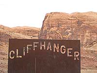 This wild story inspired the naming of the Captain Ahab Trail, which along with the Hymasa Trail, makes a loop around “The Whale.” Completed by the Grand County Trail Mix in March 2014, these trails provide a non-motorized alternative to the old uranium exploration road known as the Amasa Back-Cliffhanger jeep trail. Named after the cattleman, George Amasa Larsen, who arrived in Spanish Valley in 1880, the Amasa Back is a three mile cliff-sided ridge that forms a gooseneck hundreds of feet above the Colorado River
To get there turn west off of Main Street at MacDonald’s on to Kane Creek Blvd. Then drive approximately six miles to the trailhead. During the tourist season Hymasa and Captain Ahab are popular mountain biking trails. If you want to avoid the crowds, do this hike in the winter, but keep in mind that a few bikers still use it year round. Also keep in mind that a bike trail is seldom the most direct route!
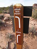
 Hymasa is a two-track going up to the ridge of Amasa Back, while Captain Ahab is a one-way going down. At each junction there is a map with a “you are here smiley face.” All total if you cover the entire distance you are looking at an eight mile hike. A shorter loop will eliminate about three miles, but that short-cut bypasses some fantastic on-the-edge viewpoints overlooking Jackson’s Hole.
At the trailhead the Amasa Back-Cliffhanger drops straight down to Kane Creek. Hymasa, on the other hand, immediately veers off to the left for a separate, more gradual route down to the creek where it merges with the original trail. At the crossing the volume of water varies depending on recent rains and spring run-off. When it is high getting across can be very difficult, but on this day in early December jumping from rock to rock is as easy as child’s play.
 A quarter of a mile after the crossing I pass by the exit for Captain Ahab. A very short distance later I hang a right for the Hymasa. After that, it weaves back and forth across the Amasa Back-Cliffhanger for the next 1.4 miles.
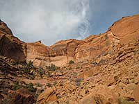
As Kane Creek gradually disappears from sight, the stunning sandstone configurations in Behind The Rocks erupt into view with a humongous collection of domes and fins – a dramatic contrast to the breathtaking vision of the La Sal Mountains enshrouded in a heavy blanket of snow– and WOW - even ocassional glimpses of some of the distinctive landmarks in Arches National Park. Then glancing down from whence I came, I feel like I’m gazing upon a big bowl – a basin etched with scalloped edges, ridges, mini cliffs and flat mesas surrounded by the sheer immensity of sandstone walls.
At approximately 2.5 miles, I have reached the sign for the Ahab Mid-point, the short cut to Captain Ahab. Somewhere near here I avoid the unmarked trail to the right as it returns to the jeep trail. About 3.7 miles later, Hymasa ends on Captain Ahab, and now the trail starts following the Amasa Back ridge as it continues on the upper loop around “The Whale.”
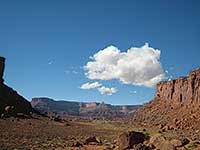
It’s been a workout; I’m ready to stop, settle in for lunch and kick back, relishing this incredulous scene that spreads out in all directions. From my cliff-hanging perch this is what I see: the La Sals - Deadhorse Point - sheer Wingate cliffs carved out by the Colorado River – and the rincon of Jackson’s Hole, an abandoned bend in the Colorado River.
I can also make out the indistinct imprint of Jacob’s Ladder, an ancient Native American trail that follows a jagged crack down a 400 foot cliff. In the early 1900s John Jackson, a determined rancher, used this ladder-like trail to move his horses back and forth from the river to the Amasa Back. With the steep grade and abrupt switchbacks, it’s hard to fathom how this treacherous route worked as a thoroughfare for horses!
 Since there is so much to absorb, time is forgotten. When I look at my watch I am shocked. Suddenly dalliance is no longer an option. If I don’t hustle, I’ll be getting back in the dark!
Four miles still to go, and the race is on! Hastily I make my way around “The Whale.” At least it is mostly downhill, but after awhile it’s a downward journey filled with big steps and flying leaps, and it amazes me how skilled mountain bikers take all this in stride.
Eventually the trail narrows as it leans in closer to the cliff’s edge. At a sharp bend there’s a sign - WALK YOUR BIKES - followed by a blue arrow painted on the rock. A table top rock formation hanging precariously above the trail grabs my attention, some day just like Humpty Dumpty, it will come tumbling down. At another spot a tight squeeze through two boulders explains why this is a one-way route.
After awhile, off in the distance I can see my car – a straight shot away, if I could fly! But on foot it’s at least several more miles. Moving along the serene setting of Kane Creek finally appears, and just as the sun starts sinking below the horizon – PHEW - WHAT A RELIEF – at last I’m back where I started!