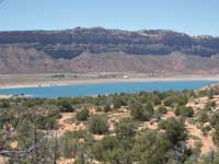
Ken’s Lake, a man-made surprise, just happens to be located smack dab in the middle of a desert environment in Upper Spanish Valley - a body of deep blue water that contrasts sharply against the surrounding arid landscape. Diverted out of Mill Creek at the Sheley Tunnel near Flat Pass, it feeds a 645 foot torrential rush over boulders and rock ledges - a crash course to Faux Falls followed by a mad dash to the lake. “Faux” is French for “false” or “fake”, but on an overly warm day, this cool, supercharged waterfall feels real enough to me.
Around the beginning of the twentieth century Horace Sheley attempted to construct the tunnel, but was unsuccessful in boring through the sandstone. After that first attempt, the project languished for decades until the early 1970’s when a cycle of drought pressed the need for more water. Finally, after years of planning, ground breaking began on October 4, 1979.
Ken McDougald, former mayor and water conservancy district chairman, labored for 15 years before this project was completed. Named in his honor, Ken’s Lake was dedicated on June 5, 1981 – an enterprise developed mainly for irrigation purposes in upper Spanish Valley, long known as Poverty Flats because of its serious lack of water.
To get to Ken’s Lake from Moab go south on Highway 191 approximately 7.5 miles and turn left at the sign for the Ken’s Lake-La Sal Loop Road. Then continue to the stop sign and turn right. After driving about 1.4 miles, turn left on the Ken’s Lake-Flat Pass Road and follow the sign to Ken’s Lake.
The Ken’s Lake Recreation Area includes three trails - the Lake Loop, Faux Falls and the Rock Loop. A short trail also connects the parking area at the lake with the campground, where the Faux Falls-Rock Loop trails begin.
Ken’s Lake, particularly during spring migration, attracts a variety of birds - mallards, coots, Wilson’s phalaropes, ring-necked ducks, common mergansers, etc. On my last visit I also watched swarms of violet-green swallows flit across the water, while a pterodactyl looking great blue heron flew overhead. Amidst the willows the red-winged blackbirds burst forth with their “to-ka-ree” songs as yellow warblers and yellow-rumped warblers energetically flitted through the leafy camouflage.
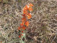
With so much birding activity it takes a while before I’m willing to budge to begin my hike to Faux Falls. On the short trail from the lake I stop often to savor the glowing orange of globemallow, while also absorbing long distance vistas - the saw- toothed profile of Behind The Rocks on the western horizon - an alluring glimpse of South Mountain and Mtn. Tukunikivatz to the southeast.
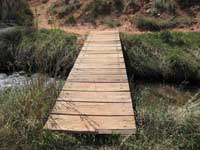
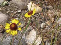
This short route stops at campsite 18, and I continue on through the campground to a billboard across from campsite 25 – the beginning of the Faux Falls- Rock Loop trails, where I immediately drop down to a wooden bridge crossing an exuberant creek. Then the signs for Faux Falls point the way to an up-and-down path paralleling the creek - a water-loving habitat of cottonwoods, scouring rush, willows and water birch – a flower producing area for Hopi blanketflower, yellow daisies and Indian paintbrush.
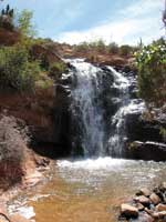
The falls can be seen during most of my walk and heard long before I get there. After three long-legged steps down, I have arrived at a rush of water on steroids! The roar is deafening as water plunges hundreds of feet ending with a free fall dive into a turbulent pool. And there in the middle of this whirlpool what do my wondering eyes see but a chunky, slate gray bird – it’s a dipper hopping in and out of water that swirls around like a washing machine! But this is what dippers do for it is the only North American aquatic songbird that catches all its food by swimming or walking on the turbulent stream bottom.
After my luxurious long lunch break, I finally tear myself away from this cool refreshment to leave the very wet to go to the very dry. Retracing my footsteps for a short distance I end up on a new-to-me trail that connects to the Rock Loop Trail. Leaving the lushness of the riparian world behind, I have now entered a land that is anchored down with scattered junipers, blackbrush, Indian rice grass and Mormon tea - a habitat that hunkers down and waits for the rain to come – a place where the evening primrose, those lovely white ladies of the desert, have responded profusely to an abundance of spring showers.
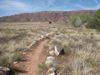
Before long I’ve reached the Rock Loop Trail, which offers an interesting circle around a large outcrop of Navajo Sandstone called “The Rock.” Except for one short stretch of sand on the upper end, this one-mile trail is well marked with rock cairns and signs. In this wide open area a pair of love-struck mourning doves coo their melancholy song before whizzing away on whistling wings, while several gnatcatchers hold tight as they whisper so softly from the junipers.
The dramatic scene on the eastern horizon rivets my attention to a stunning parade of sandstone structures, which travel in a north-south direction. If I could fly above them, I’d be looking down on Mill Creek. They flank both sides of Flat Pass, while another section of sheer cliffs stretches up almost to the edge of Johnson’s Up On Top - a massive concentration of gargantuan slabs of rocks, rocks and more rocks - a frenzy of wild contortions either tilted sideways, backwards or shooting straight up from the ground.
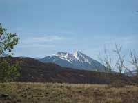
As I make the final swing around The Rock I capture a brief glimpse of the lake before descending into a wash down to the bridge. After that, the short walk back to my car completes a fulfilling three mile hike that has been enhanced by the cooling cascade of a waterfall, a wealth of wildflowers, the wonder of birds and a dynamic scene governed by a red rock landscape, that is highlighted by the snowy outline of the La Sal Mountains.