HIKING HAPPENINGS February 2013
Sand Flats - Hiking in a Winter Wonderland
by Marcy Hafner |
 Bordered by two wilderness study areas – Negro Bill to the north and Mill Creek to the south - the Sand Flats Recreation Area receives more than a 100,000 visitors a year. Even though it is famous for the Slickrock Bike trail and almost 40 miles of jeep trails, the hiking opportunities within its 7,320 acres shouldn’t be overlooked. A mere ten minute drive from downtown Moab, this public treasure is the perfect place for jeepers, bikers and hikers to enjoy the full circle, horizontal panorama of Arches National Park, the jagged rim of Behind The Rocks and the alpine beauty of the La Sal Mountains. Bordered by two wilderness study areas – Negro Bill to the north and Mill Creek to the south - the Sand Flats Recreation Area receives more than a 100,000 visitors a year. Even though it is famous for the Slickrock Bike trail and almost 40 miles of jeep trails, the hiking opportunities within its 7,320 acres shouldn’t be overlooked. A mere ten minute drive from downtown Moab, this public treasure is the perfect place for jeepers, bikers and hikers to enjoy the full circle, horizontal panorama of Arches National Park, the jagged rim of Behind The Rocks and the alpine beauty of the La Sal Mountains.
In response to the recreational overload, the Moab community, Americorps, Grand County and the Bureau of Land Management (BLM) collaborated in 1995 with the intent of preserving this precious resource. This coalition precipitated an unusual partnership between the county and the BLM so they could manage, protect, maintain and rehabilitate the land, while also providing access to sustainable and enjoyable recreational opportunities.
 In order to meet these goals, it became necessary to charge entrance and camping fees. 120 campsites are open year round on a first come, first serve basis, and many campsites can accommodate RVs, but there are no hook-ups. Water is not available, and in the heat of the summer you need to bring a truckload. In order to meet these goals, it became necessary to charge entrance and camping fees. 120 campsites are open year round on a first come, first serve basis, and many campsites can accommodate RVs, but there are no hook-ups. Water is not available, and in the heat of the summer you need to bring a truckload.
To get to this outstanding recreational area, turn east off of Main Street at the Moab Information Center on to Center Street. At 400 East go right. Then turn left at Dave’s Corner Market on to Mill Creek Drive and continue up the steep winding road to the entrance booth.
On this bone-chilling, deep-in-the freezer day, I am bundled up for an invigorating, rambling-through-the snow hike on the Fins & Things jeep trail. As I gaze out on this overcast winter wonderland, however, it blows my mind that approximately 150 million years ago the Colorado Plateau was located near the equator! And way back then, it was a drastically different environment – a hot, sandy place engulfed by wind-whipped sand dunes. But then, as the geological clock marched on, those huge piles of sand petrified into the mounds of Navajo Sandstone we see today throughout this recreational area.
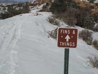
 The entirety of the Fins &Things trail is 9.4 miles, but since it parallels the Sand Flats Road you can enter and exit at various intervals for a shorter hike. The highly visible radio tower, one mile beyond the pavement on a well-maintained dirt road, is a regularly used access. A Fins & Things sign indicates the turn for parking at two pullouts, and this is where I choose to start my hike. The entirety of the Fins &Things trail is 9.4 miles, but since it parallels the Sand Flats Road you can enter and exit at various intervals for a shorter hike. The highly visible radio tower, one mile beyond the pavement on a well-maintained dirt road, is a regularly used access. A Fins & Things sign indicates the turn for parking at two pullouts, and this is where I choose to start my hike.
The snow has buried the white painted markers on the slickrock, but the four-wheel drivers have packed down the route, making my walk so much easier as I start a downhill stroll. Where the trail levels out there’s a junction, and I go right to follow the Fins & Things signs. Before long I’m at the next intersection, where I continue straight in an easterly direction rather taking a left.
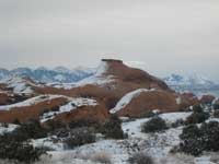
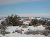
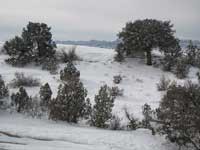
 Since I’m not floundering in the snow, I am able to concentrate my energies on the beautiful white world that surrounds me: the pinyons and junipers decked out with a heavy layer of white fluff – a scattering of snow on the fins, which suggests a dusting of powdered sugar - a whiter, sharper silhouette of Behind The Rocks – and the La Sals flaunting a magnificent banner of fresh snow. On this cloud-laden day, any sudden burst of sunlight turns the crystallized snow into a magical display that looks like thousands of sparkling diamonds. Since I’m not floundering in the snow, I am able to concentrate my energies on the beautiful white world that surrounds me: the pinyons and junipers decked out with a heavy layer of white fluff – a scattering of snow on the fins, which suggests a dusting of powdered sugar - a whiter, sharper silhouette of Behind The Rocks – and the La Sals flaunting a magnificent banner of fresh snow. On this cloud-laden day, any sudden burst of sunlight turns the crystallized snow into a magical display that looks like thousands of sparkling diamonds.
Moving along, I am relieved that I can skirt around the icy slipperiness of a cattleguard, which has a speed limit sign of five mph! Some time after that, I am rushing through the cold shadows of a long series of fins! Using that momentum, I continue to power walk up two steep, snow-encrusted hills. Then at a high point, I stop and take a long look at the winding road ahead, which appears to travel on from here to eternity! Suddenly with no apparent end in sight, I feel deflated as it dawns on me that this is as far as I wish to go on this high-energy, invigorating hike! My goal of reaching the Diving Board Rock on the Sand Flats Road will have to wait for a warmer day!
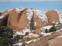 At this turning around point, I discover an honest-to-goodness snow-free section of slickrock, and with a grateful sigh I plop down for a much-needed break. At last I can pause to refuel my body with some high-octane food! It doesn’t take long, however, before my fingers and feet start to feel numb, and I find myself wishing for some heavenly warmth from the sun so I can linger, and soak in this snowbound scenery. But as the veiled curtain of melancholy clouds continues to thicken into a brooding soup the harsh reality hits; the sun has departed for the rest of the day and it’s much too cold to lounge here any longer! Consequently, as soon as I’ve gulped down my food, I’m up and swiftly moving along anxiously trying to generate some warmth as I retrace my steps back to the radio tower. At this turning around point, I discover an honest-to-goodness snow-free section of slickrock, and with a grateful sigh I plop down for a much-needed break. At last I can pause to refuel my body with some high-octane food! It doesn’t take long, however, before my fingers and feet start to feel numb, and I find myself wishing for some heavenly warmth from the sun so I can linger, and soak in this snowbound scenery. But as the veiled curtain of melancholy clouds continues to thicken into a brooding soup the harsh reality hits; the sun has departed for the rest of the day and it’s much too cold to lounge here any longer! Consequently, as soon as I’ve gulped down my food, I’m up and swiftly moving along anxiously trying to generate some warmth as I retrace my steps back to the radio tower.
As I trudge up that final hill, a bunch of fun-loving kids whiz past me on their sleds. Then they slog back up to do it all over again and again! With plenty of spare energy to pursue this engaging activity indefinitely, these youngsters playfully enjoy a romp in their enchanting winter wonderland playground, as I now contentedly savor this delightful scene from the shelter of my truck!
|
Biological Soil Crust (aka)
Cryptos (krip’ tose):
The surface of
Moab’s desert is held
together by a thin skin of living organisms known as cryptobiotic
soil or cryptos. It has a lumpy black appearance, is very
fragile, and takes decades to heal when it has been damaged.
This soil is a critical part of the survival of the desert.
The cryptobiotic organisms help to stabilize the soil, hold
moisture, and provide protection for germination of the seeds
of other plants. Without it the dry areas of the west would
be much different. Although some disturbance is normal and
helps the soil to capture moisture, excessive disturbance
by hooves, bicycle tires and hiking boots has been shown
to destroy the cryptobiotic organisms and their contribution
to the soil. When you walk around Moab avoid crushing the
cryptos. Stay on trails, walk in washes, hop from stone to
stone. Whatever it takes, don’t crunch the cryptos
unless you absolutely have to! |
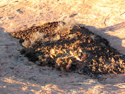
Cryptobiotic soil garden
|
|
|