HIKING HAPPENINGS MAY 2012
A Two Trail Walk - Jackson’s and Rockstacker
article and photos by Marcy Hafner
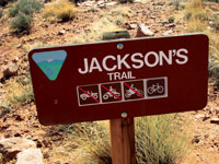 This is the tale of two distinctive trails - Jackson’s, an old-timers trail, and Rockstacker, a brand new ultra technical mountain biking trail. One hundred years have gone by since the Jackson’s Trail was created - a grandfather compared to the recent birth of the Rockstacker Trail. My story starts with the Jackson’s Trail, a hard-breathing two mile ascent that provides access to the Rockstacker Trail. This is the tale of two distinctive trails - Jackson’s, an old-timers trail, and Rockstacker, a brand new ultra technical mountain biking trail. One hundred years have gone by since the Jackson’s Trail was created - a grandfather compared to the recent birth of the Rockstacker Trail. My story starts with the Jackson’s Trail, a hard-breathing two mile ascent that provides access to the Rockstacker Trail.
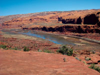 John Jackson, a rancher with a feisty personality, was searching in the early 1900’s for a short cut to move his horses from the Shafer Basin country to Moab. During his search, he chose and established a route that followed the Jackson’s Trail for two miles to the Amasa Back - a three-mile, cliff-sided ridge that forms a gooseneck hundreds of feet above the Colorado River. This prominent and well-known landmark is named after George Amasa Larsen, a cattleman who arrived in Spanish Valley in the 1870’s. John Jackson, a rancher with a feisty personality, was searching in the early 1900’s for a short cut to move his horses from the Shafer Basin country to Moab. During his search, he chose and established a route that followed the Jackson’s Trail for two miles to the Amasa Back - a three-mile, cliff-sided ridge that forms a gooseneck hundreds of feet above the Colorado River. This prominent and well-known landmark is named after George Amasa Larsen, a cattleman who arrived in Spanish Valley in the 1870’s.
Quickly dropping off the Amasa Back, Jackson then guided his horses down the abrupt switchbacks of Jackson’s Ladder (also known as Jacob’s Ladder) – an ancient Native American trail that follows a jagged crack along a 400 foot cliff. Hopefully, when the dramatic descent ended, all his equines arrived intact at Jackson’s Hole, an abandoned bend of the Colorado River referred to as a “rincon.”
To get to the trailhead from the center of town, go south on Main Street and turn right at McDonald’s on to Kane Creek Blvd. Then drive approximately five miles. When the pavement changes to dirt, turn in at the second parking area, where the Jackson’s Trail starts immediately to the left of the bulletin board.
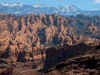 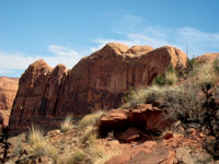 The first segment of the trail is a more recent and very welcome addition that winds around Kane Creek to access an easier crossing. At the antiquities sign, however, be sure to swing right - the left spur dead-ends in a thicket of tamarisk! Keep in mind that during high water, usually May and June, the river backs up into the creek and may be impassable. The first segment of the trail is a more recent and very welcome addition that winds around Kane Creek to access an easier crossing. At the antiquities sign, however, be sure to swing right - the left spur dead-ends in a thicket of tamarisk! Keep in mind that during high water, usually May and June, the river backs up into the creek and may be impassable.
Following Kane Creek to its confluence with the Colorado River, the pathway wanders through a riparian zone of tamarisk, willow and huge cottonwood trees. Edged by sagebrush, saltbush, rabbitbrush and greasewood, this shaded area attracts a variety of birds.
After leaving the wet zone, the trail quickly starts its north-facing climb through the exposed layers of Kayenta Sandstone as it travels along a distinctive westward contour above the Colorado River. Steadily moving upward, I am constantly rewarded with the expansive views of the river and the imposing cliffs of Wingate and Navajo Sandstone, which thrust up from the shores of the meandering waterway. With the steady gain in elevation, the angle and perception of the Poison Spider mesa, Behind The Rocks and the Moab Rim constantly changes - an already stunning canvas that is enhanced by the cooling vision of the La Sal Mountains on the southeastern horizon.
The Jackson’s Trail merges with the Amasa Back Trail – a popular jeep and mountain biking route that follows the wide switchbacks of an old uranium exploration road. Just below that union, a map marks the route for two trails - Rockstacker and Pothole Arch. Rockstacker comes first, and after 1.6 miles it connects with the Pothole Arch Trail.
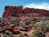 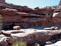 Now I am walking on the so-called “Red Line Trail” and before long I’m following the red lines painted over large sections of slickrock. I, however, learned the hard way that paying strict attention to those faded red lines, which are sometimes hard to see, is a good idea! Now I am walking on the so-called “Red Line Trail” and before long I’m following the red lines painted over large sections of slickrock. I, however, learned the hard way that paying strict attention to those faded red lines, which are sometimes hard to see, is a good idea!
The Rockstacker, with its unending views of the river, runs directly below the ridgeline of the Amasa Back. Its gentle beginnings, however, are deceiving as to the extremely rugged ledgy terrain that awaits ahead - a sharply undulating rocky path that amazingly gains very little elevation. This challenging course involves incredible leaps that mountain bikers must negotiate to make a safe landing!
As I progress along, an appealing indentation within a small cliff beckons me to pause in its protective shade. Shortly after that, the trail takes a circuitous route above a large rock amphitheater, which has the striking effect of looking down into a gigantic gray bowl. Then I’m climbing steeply along big looping switchbacks from one level to another that involves some exceedingly steep grades. The final stretch is a rubbly scramble to the top of the Amasa Back mesa where the Rockstacker Trail finally joins the Pothole Arch Trail.
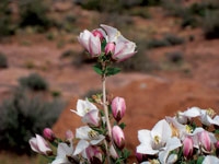
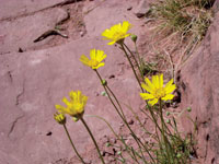
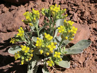
During my entire invigorating walk, I have enjoyed immensely the spring season of wildflowers – the tiny yellow blooms of the Newberry’s twinpod, the exquisite white flowers of the fendlerbush and the daisy-like naked stem bahia. Even with so little moisture this year, they tenaciously grow with enough energy left over to produce flowers. I have also been enchanted with the delightful chorus of birds that reverberates through the dry desert air - the ringing trills of the rock wren, the musical warble of the house finch and the performance of a spotted towhee with his invitation to “Drink Your Tea.”
On this particularly warm day, a refreshing breeze entices me to stay, and I decide this is as far as I wish to go. Stretched out on my rocky perch, I make myself comfortable for a very long break to study this extensive scene that I’ve been observing all along. But now I’m seeing it from the perception of a much higher elevation, and with time to spare, I’m savoring my chance to concentrate on this in depth rugged desert panorama, which stretches out for miles and miles.
If you want to continue on to the end of the Pothole Arch Trail, it is slightly less than a mile on an easy-going, well-marked route cradled between various curvaceous domes. And yes, at the end of the trail there is an arch along with more spectacular views. But that’s a story for another day.
|
Biological Soil Crust (aka)
Cryptos (krip’ tose):
The surface of
Moab’s desert is held
together by a thin skin of living organisms known as cryptobiotic
soil or cryptos. It has a lumpy black appearance, is very
fragile, and takes decades to heal when it has been damaged.
This soil is a critical part of the survival of the desert.
The cryptobiotic organisms help to stabilize the soil, hold
moisture, and provide protection for germination of the seeds
of other plants. Without it the dry areas of the west would
be much different. Although some disturbance is normal and
helps the soil to capture moisture, excessive disturbance
by hooves, bicycle tires and hiking boots has been shown
to destroy the cryptobiotic organisms and their contribution
to the soil. When you walk around Moab avoid crushing the
cryptos. Stay on trails, walk in washes, hop from stone to
stone. Whatever it takes, don’t crunch the cryptos
unless you absolutely have to! |
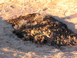
Cryptobiotic soil garden
|
|
|
 This is the tale of two distinctive trails - Jackson’s, an old-timers trail, and Rockstacker, a brand new ultra technical mountain biking trail. One hundred years have gone by since the Jackson’s Trail was created - a grandfather compared to the recent birth of the Rockstacker Trail. My story starts with the Jackson’s Trail, a hard-breathing two mile ascent that provides access to the Rockstacker Trail.
 John Jackson, a rancher with a feisty personality, was searching in the early 1900’s for a short cut to move his horses from the Shafer Basin country to Moab. During his search, he chose and established a route that followed the Jackson’s Trail for two miles to the Amasa Back - a three-mile, cliff-sided ridge that forms a gooseneck hundreds of feet above the Colorado River. This prominent and well-known landmark is named after George Amasa Larsen, a cattleman who arrived in Spanish Valley in the 1870’s.
 The first segment of the trail is a more recent and very welcome addition that winds around Kane Creek to access an easier crossing. At the antiquities sign, however, be sure to swing right - the left spur dead-ends in a thicket of tamarisk! Keep in mind that during high water, usually May and June, the river backs up into the creek and may be impassable.
 Now I am walking on the so-called “Red Line Trail” and before long I’m following the red lines painted over large sections of slickrock. I, however, learned the hard way that paying strict attention to those faded red lines, which are sometimes hard to see, is a good idea!