HIKING HAPPENINGS
September 2009
The Shafer Creek Trail – A Wealth Of Wildflowers
by Marcia Hafner
During the summer, the lure of the high country is irresistible – like a mythological siren song it calls –Come to me! Leave the heat behind and come to me so you can enjoy the lush green meadows, the clear running streams, the quaking aspens and, most of all, the huge bounty of beautiful wildflowers.
It’s an invitation I readily accept, and at Warner Lake a noticeable drop in temperature makes me very happy. With cool refreshing air, a beautiful lake, and an idyllic mountain setting – Who could ask for anything more? If you want to stay for a while, the campground has twenty sites, the group area accommodates fifty people, and a cabin for four is also available. A sign, however, now warns that the water at the campground is not safe for drinking.
To get there, drive almost 8-miles south from the center of town on Highway 191 and turn left at the Ken’s Lake–La Sal Loop sign. Then take a right at the “T” intersection. That will put you on Spanish Valley Drive, which becomes the La Sal Loop - a road that climbs steeply into the mountains. The Warner Lake Road is 12.7 miles from the “T” after going past the Geyser Pass and Oowah Lake turnoffs. Despite the washboard, this five-mile graveled road is suitable for any vehicle, but it is closed during the winter season.
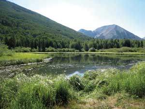 According to the Canyon Legacy – Volume 41, Warner Lake was originally known as “The Upper Place” back in the early days when Herbert Day, his wife Mary and their twelve children lived there for the summer. During that short season it provided good grazing for their dairy cows and when winter set in, they moved down to the “Lower Place”, now known as Wilson Mesa. Herbert and his older sons built the dam at Warner Lake to install an irrigation system. Abandoned in 1912, none of the original buildings remain and in the spring of 1933, the Civilian Conservation Corps did a lot of grunt work to improve the dam and reservoir. According to the Canyon Legacy – Volume 41, Warner Lake was originally known as “The Upper Place” back in the early days when Herbert Day, his wife Mary and their twelve children lived there for the summer. During that short season it provided good grazing for their dairy cows and when winter set in, they moved down to the “Lower Place”, now known as Wilson Mesa. Herbert and his older sons built the dam at Warner Lake to install an irrigation system. Abandoned in 1912, none of the original buildings remain and in the spring of 1933, the Civilian Conservation Corps did a lot of grunt work to improve the dam and reservoir.
For a hike on the Shafer Creek-Mill Creek Trail that goes through Schulman Gulch, I walk past the lake and at the first fork with a sign, I go right for the Oowah Lake-Schulman Gulch Trail rather than turning left on to the Burro Pass-Dry Fork Trail. At the next marked intersection, I leave the Oowah Lake Trail and turn right on to the Schulman Gulch Trail. This puts me on a gentle old road where soon a final (!) sign informs me to stay left on the Shafer Creek-Mill Creek Trail, which is two miles long. The right fork returns to the Warner Lake Road, and I definitely don’t want to do that.
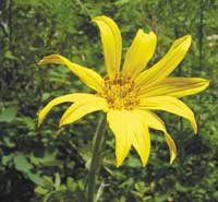
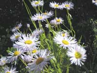
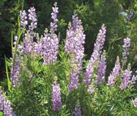
Wildflowers are the name of the game on this hike. In the more open areas I walk through fields of blue-purple lupines, tall eye-catching flowers in the bean family that produce beanlike seedpods. Scattered around here, there, everywhere are lovely lavender aspen daisies. Also known as showy daisies, these beauties resemble small sized asters. In the wetter areas, the fragrant soft pink wild roses grow side by side with creamy-white, pink-veined Richardson’s geraniums.
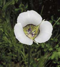
The best of show, however, goes to Utah’s state flower, the exquisite sego lily. A native West of the Rocky Mountains, in parts of the region it is sometimes referred to as the mariposa lily. Looking like a wild tulip this delicate flower has three white to lavender petals with a yellow base. Especially abundant in Utah, early Mormon settlers quickly learned that the bulbous roots would supply a much needed source of food.
At the beginning of the trail, as I’m wandering through huge groves of aspens with fantastic views of Haystack Mountain, Mount Mellenthein, Laurel Peak, Mount Tukinikivatz and Tuk No, a dusky grouse (formerly known as a blue grouse) unexpectedly flushes out. Holding tight until the very last minute before exploding into the air, that sudden whoosh of feathers always startles me. A strong short distance flier, this upland game bird instinctively flies downhill, weaving deftly like a slalom skier through the thick trees.
In late November the grouses’ unusual migration strategy kicks in, and rather than heading south or down to lower elevations, they strike out walking, not flying toward higher ground. Taking shelter beneath snow-draped limbs of fir or spruce, they will nibble on the needles of the same tree for weeks.
The male’s courtship display is amazing to watch as he tries hard to attract the ladies. Spreading his tail like a fan, he also retracts the white base feathers on his neck to expose two raspberry air sacs. Then, drooping his wings, he continuously bobs his head while sucking air in and out like an accordion in order to boom out a series of enticing hoots.
Gradually the trail swings down through a tall grassy area where a curious deer takes a long look at me before ambling off. Often I hear the bubbling buzzy trills of house wrens, and sometimes I even get a glimpse of these small, secretive birds followed by a scattering of some fresh out of the nest juveniles.
Abruptly I’m slip-sliding down some steep switchbacks to the Mill Creek drainage. It is on this pebbly descent that I discover the hard way that muddy sections are as slick as grease. As I keep advancing downward, the stream crossings become more numerous. More water means more vegetation until I’m enclosed in a riparian jungle.
The banks of Shafer Creek, covered with cushy clover, soft green grass and the tiny smiling faces of yellow monkeyflowers, invite me to stay. When I test the water, I find it just right for feet dangling or wading. Sitting beside the clear rushing stream, I am mesmerized by the trout swimming by and the hypnotic ribbon-like flow of midget-sized insects that are following a back-and-forth route above the creek.
A gathering of fluffy white non-threatening thunderheads puts me in a peaceful, unhurried frame of mind, and knowing I don’t have much further to go, I contentedly move along to the final segment of my hike. After negotiating a tricky crossing over Mill Creek, I scramble up the short but very steep ascent to the Oowah Lake Road. If you arrange for a shuttle, someone can pick you up here approximately one mile beyond the La Sal Loop Road. Or you can do a loop by hoofing it 11/2 miles up the Oowah Lake Road to take the Oowah Lake Trail back to Warner Lake.
The Shafer-Mill Creek Trail with its huge bouquet of brilliant wildflowers is so appealing during the summer. If you want to see them - do it now, before it is too late for already they are starting to fade. By mid September most of them will be gone. Then it will be time to get ready for fall, when the mountains take on the glow of aspen gold.
|
Biological Soil Crust (aka)
Cryptos (krip’ tose):
The surface of
Moab’s desert is held
together by a thin skin of living organisms known as cryptobiotic
soil or cryptos. It has a lumpy black appearance, is very
fragile, and takes decades to heal when it has been damaged.
This soil is a critical part of the survival of the desert.
The cryptobiotic organisms help to stabilize the soil, hold
moisture, and provide protection for germination of the seeds
of other plants. Without it the dry areas of the west would
be much different. Although some disturbance is normal and
helps the soil to capture moisture, excessive disturbance
by hooves, bicycle tires and hiking boots has been shown
to destroy the cryptobiotic organisms and their contribution
to the soil. When you walk around Moab avoid crushing the
cryptos. Stay on trails, walk in washes, hop from stone to
stone. Whatever it takes, don’t crunch the cryptos
unless you absolutely have to! |
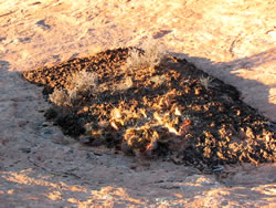
Cryptobiotic soil garden
|
|
|