HIKING HAPPENINGS
April 2008
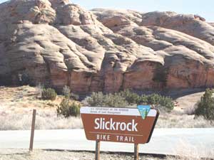
The Slickrock Bike Trail - To the Abyss And Beyond
by Marcia Hafner
 Don’t let the name or reputation of this world famous biking trail fool you. It is a great place for hikers, too. This is especially true in late winter when the snow meltdown has turned many trails into a gooey, messy mud-walk. That’s when the Slickrock Trail is a sure guarantee for a dry, pleasurable hike on Navajo sandstone. Don’t let the name or reputation of this world famous biking trail fool you. It is a great place for hikers, too. This is especially true in late winter when the snow meltdown has turned many trails into a gooey, messy mud-walk. That’s when the Slickrock Trail is a sure guarantee for a dry, pleasurable hike on Navajo sandstone.
To get to the Slickrock Bike Trail, going south on Main Street, take a left (at the Moab Information Center) on to Center Street and follow it to the stop sign on 400 East. Take a right and continue on 400 East for five blocks. At Dave’s Corner Market turn left on to Mill Creek Drive. At the stop sign go straight and drive up the steep, winding Sand Flats Road. You will pass the recycling center and the landfill before entering the Sand Flats Recreation Area (SFRA) where there is an entrance fee booth. For three days on a mountain bike the charge is $2.00. By car, it is $5.00. The real bargain for a longer stay is the annual pass for $20.00. The trailhead parking lot is on the left hand side and is 1.5 miles from Dave’s Corner Market.
Almost 100,000 visitors come to the SFRA every year. In 1995 - in response to too many recreationists having way too much fun - the Moab community, Americorps, Grand County and the Bureau of Land Management (BLM) collaborated to preserve this precious resource. A unique partnership between Grand County and the BLM was formed so they could manage, protect, maintain and rehabilitate the 7,320 acres that encompass it. The entrance fees are essential for paying the cost of meeting these goals.
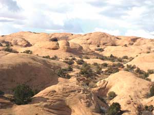 Once upon a time - - about 190 million years ago towards the end of the Triassic period - - huge wind-blown sand dunes covered this area. Then a shallow sea invaded the region. When the waters departed, the shifting sands remained and eventually petrified into Navajo sandstone, which are a distinctive feature of the Slickrock Trail. Once upon a time - - about 190 million years ago towards the end of the Triassic period - - huge wind-blown sand dunes covered this area. Then a shallow sea invaded the region. When the waters departed, the shifting sands remained and eventually petrified into Navajo sandstone, which are a distinctive feature of the Slickrock Trail.
Early settlers invented the word “slickrock” because their metal shod horses found the barren rock slick to trod on. It’s just the opposite for hikers and bikers. Vibram soles and rubber tires get excellent traction on its sandpaper coarseness except when it is wet. Then it does get slick.
Former Moab resident Dick Wilson, referred to as “Mr. Slickrock” by a local businessman, formulated the idea of putting a motorcycle trail on the slickrock. The BLM approved it in May 1969. Wilson immediately marked the route, including a practice loop and several spur routes, while naming some of the unique features such as Abyss Viewpoint, Shrimp Rock and Updraft Arch that he found along the trail. The BLM painted the trail with broken white lines and dedicated it on July 22, 1969. Over the years some alterations have been made, but the biggest change came in the 1980’s when mountain bikers adopted it.
The steady up and down of the undulating slickrock hills is characteristic of the entire 10.5-mile loop trail, which is classified moderate in difficulty for hikers. Depressions filled with soil have created small gardens filled with junipers, pinyon pines, yucca, scrub oak and prickly pear. The Hell’s Revenge jeep trail, which is marked by painted yellow flames, crosses it six times.
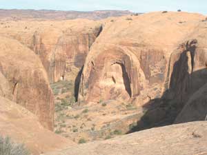 It is 1.5 miles to the Abyss Viewpoint. When I’m at that spot I do get a giddy feeling of being on the brink of “The Abyss” as I look straight down into the steep-walled magnitude of Abyss Canyon, a sidebar canyon of Negro Bill. It is 1.5 miles to the Abyss Viewpoint. When I’m at that spot I do get a giddy feeling of being on the brink of “The Abyss” as I look straight down into the steep-walled magnitude of Abyss Canyon, a sidebar canyon of Negro Bill.
The loop section of the trail starts about a mile after the Abyss Viewpoint. If you take the left easier route (for bikes, that is), you’ll swing up and around to Swiss Cheese Ridge where an in-depth view of Moab Valley and The Portal awaits you. The right-hand route has a habit of pulling me along like a magnet, up one hill and down another, as the La Sal Mountains, the jagged rim of Behind The Rocks, The Bookcliffs and Arches National Park pop in and out of view. Most intriguing to me is the occasional vision of the Three Gossips, a distinctive landmark in the park. The trail swings around above the cliffs on the south side of the Colorado River. If you make it that far and it is your lucky day, a peregrine falcon might whiz by. The falcons nest on cliff ledges along the river corridor, and once during a break at Updraft Arch I watched this speed demon bird of prey pass directly overhead.
There is plenty of room on this trail for hikers and bikers. As a courtesy to those on mountain bikes, do step aside to let them pass. I often stop to marvel and gasp at the strength and nerve of a skilled rider who can negotiate the steep, sharp angles after the hard uphill pump to get there. Some places they go, I tread with great care. Then on the downhill I look on enviously at their high-flying, speed-along roller coaster ride.
This trail is most crowded in the spring, but it’s also popular in the fall when weather conditions are at their optimum. It loses its appeal in the summer when temperatures rise above the century mark. Then it becomes a recipe for a blazing workout in a land of minimal shade and heat that radiates off bare slickrock like a convection oven. If you insist on doing it anyway, be sure to carry a huge supply of water.
What a difference the winter months make when the trail often disappears in a bed of snow, making it icy and treacherous! To enjoy that winter season of solitude, I wait for any window of opportunity when snow is not on the trail.
A quick ten-minute drive out of town makes this highly accessible treasure ideal for many spontaneous, short outings. Now that I’ve discovered that the Slickrock Bike Trail isn’t just for mountain bikes, I’ll be returning to it often.
|
Biological Soil Crust (aka)
Cryptos (krip’ tose):
The surface of
Moab’s desert is held
together by a thin skin of living organisms known as cryptobiotic
soil or cryptos. It has a lumpy black appearance, is very
fragile, and takes decades to heal when it has been damaged.
This soil is a critical part of the survival of the desert.
The cryptobiotic organisms help to stabilize the soil, hold
moisture, and provide protection for germination of the seeds
of other plants. Without it the dry areas of the west would
be much different. Although some disturbance is normal and
helps the soil to capture moisture, excessive disturbance
by hooves, bicycle tires and hiking boots has been shown
to destroy the cryptobiotic organisms and their contribution
to the soil. When you walk around Moab avoid crushing the
cryptos. Stay on trails, walk in washes, hop from stone to
stone. Whatever it takes, don’t crunch the cryptos
unless you absolutely have to! |
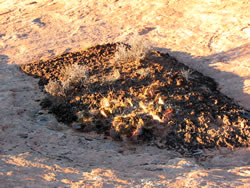
Cryptobiotic soil garden
|
|
|