HIKING HAPPENINGS
September 2007
Warner Lake -
A Cool Escape
by Marcia Hafner
 A blistering desert hike on a scorching summer day makes
no sense to me. Instead I toss my pack into the truck and
head for the refrigerated coolness of the high country. I
want relief and find it at Warner Lake. At 9400 feet, it
is a cool escape from the oven baking heat I left behind
just forty-five minutes ago on the valley floor. A blistering desert hike on a scorching summer day makes
no sense to me. Instead I toss my pack into the truck and
head for the refrigerated coolness of the high country. I
want relief and find it at Warner Lake. At 9400 feet, it
is a cool escape from the oven baking heat I left behind
just forty-five minutes ago on the valley floor.
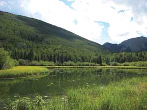
Warner Lake is a popular spot for
a lot of reasons. With its idyllic mountain scenery it’s
an ideal place to pass a lazy afternoon bird watching or
fishing for rainbow trout.
Close to the lake there’s
a picnic area and a campground with twenty tent sites.
The group campsite accommodates fifty people. A small cabin
for four people even has a shower for the frivolous get-away.
For the more active
minded, there’s
a choice of four hiking-mountain biking trails:
• Miners Basin
Trail - two miles to the pass and two more miles to Miners
Basin,
• Oowah Lake Trail – two miles,
• Burro Pass Trail – over four miles to the pass
and two and a half more to the Geyser Pass Road.
Mill Creek starts at Burro Pass and in its six-mile course
drops 1500 feet to the creek diversion at Warner Lake.
• Dry Fork-Beaver Basin Trail – five miles with a brutally steep
climb near the top.
 According to excerpts from the
histories of George A. Day and Eli Day, published in volume
41 of the Canyon Legacy, this spot was originally called “The Upper Place.” Herbert
Day, his wife, Mary and their twelve children lived here
in the summer because grazing was good for their dairy cows.
In the winter they lived in the “Lower Place,” currently
known as Wilson Mesa. They marketed their dairy products
at Miners Basin, Gold Basin, and to stockmen who worked in
the mountains. Herbert Day and the older boys built the dam
and the ditch for their irrigation system on Wilson Mesa,
but the lake was named after a forest service ranger. Abandoned
in 1912, nothing remains except the lake, dam and ditch which
is still used to transport water from Mill Creek into the
reservoir. According to excerpts from the
histories of George A. Day and Eli Day, published in volume
41 of the Canyon Legacy, this spot was originally called “The Upper Place.” Herbert
Day, his wife, Mary and their twelve children lived here
in the summer because grazing was good for their dairy cows.
In the winter they lived in the “Lower Place,” currently
known as Wilson Mesa. They marketed their dairy products
at Miners Basin, Gold Basin, and to stockmen who worked in
the mountains. Herbert Day and the older boys built the dam
and the ditch for their irrigation system on Wilson Mesa,
but the lake was named after a forest service ranger. Abandoned
in 1912, nothing remains except the lake, dam and ditch which
is still used to transport water from Mill Creek into the
reservoir.
In the spring of 1933, the Civilian Conservation Corps camp
was established at the Warner Ranger Station near the current
campground. In one season, almost 200 men completed range
improvements, overhauled trails and roads, and dug lengthy
water diversion ditches. They developed the reservoirs at
Warner, Oowah, Clark, and Medicine Lakes. The Geyser Pass
Road and the Castleton-Wilson Mesa Road, now part of the
La Sal Loop Road were also rebuilt.
 I decide to take the less traveled
Miners Basin Trail and walk about 100 yards down past the
information kiosk where a sign indicates the beginning
of the trail. It is the only sign on the trail. I follow
the footpath and climb over the wooden fence. Then there’s a right turn on to an old
dirt road. At the beginning of the trail there are two gates
that take a minimum of effort to open and close. After that
a quick right turn is easy to miss. If you end up at an enclosure
with a wooden fence next to a small water tank you’ve
gone past that turn. Trust me on this: the trails going out
from here go nowhere. Since I had no desire to do a lot of
bushwhacking, I backtracked the short distance to the turn. I decide to take the less traveled
Miners Basin Trail and walk about 100 yards down past the
information kiosk where a sign indicates the beginning
of the trail. It is the only sign on the trail. I follow
the footpath and climb over the wooden fence. Then there’s a right turn on to an old
dirt road. At the beginning of the trail there are two gates
that take a minimum of effort to open and close. After that
a quick right turn is easy to miss. If you end up at an enclosure
with a wooden fence next to a small water tank you’ve
gone past that turn. Trust me on this: the trails going out
from here go nowhere. Since I had no desire to do a lot of
bushwhacking, I backtracked the short distance to the turn.
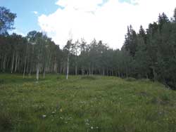
Soon I’m following a wide switchback through the aspens
to the trail register. Mountain chickadees “dee-dee-dee” their
trademark calls while red-breasted nuthatches “yank-yank-yank” a
tinny trumpeted song. The fluted chorus of the hermit thrush
adds to the forest enchantment. The thick, full branches
of the Engelmann spruce and sub-alpine fir umbrella me in
rippled shade and I use several clues to tell the difference
between them. Fir is soft to the touch (hence the name);
spruce needles are sharp. Spruce cones hang downward. With
the exception of Douglas fir, fir cones are upright.
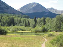
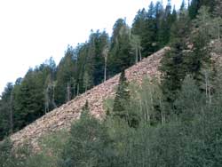 For a long time this trail holds close to the stream going
past talus slopes on the other side. An easy stream crossing
brings me into a meadow dotted with aspens. There is an abundance
of flowers from the bright yellow splash of daisies to the
explosive red of trumpet-shaped skyrocket gilia. The orange-red
Indian paintbrush and crimson columbine add to the flower
bouquet. In the shaded moist areas, I am delighted to find
exquisite blue columbine swaying in a slow, breeze-tossed
dance. A wide right curve goes past the remains of an old
cabin. Now I leave the stream and the meadow and start a
series of switchbacks through the aspens with occasional
views of the desert floor below. For a long time this trail holds close to the stream going
past talus slopes on the other side. An easy stream crossing
brings me into a meadow dotted with aspens. There is an abundance
of flowers from the bright yellow splash of daisies to the
explosive red of trumpet-shaped skyrocket gilia. The orange-red
Indian paintbrush and crimson columbine add to the flower
bouquet. In the shaded moist areas, I am delighted to find
exquisite blue columbine swaying in a slow, breeze-tossed
dance. A wide right curve goes past the remains of an old
cabin. Now I leave the stream and the meadow and start a
series of switchbacks through the aspens with occasional
views of the desert floor below.
The steady uphill is long and gradual. Getting close I can
now see the pass and that urges me onward. At the pass there’s
a small clearing surrounded by conifers. On a whispery cool
breeze, the pleasurable scent of pine fills the air. This
is much too appealing to walk on by. Thud goes my pack to
the ground for a long, refreshing break. There is no panoramic
view at this spot. For that I walk northwest an extra half-mile
to the top of Gold Knob, named for the fall golden color
of aspen.
This trail continues north two
more miles down to Miners Basin but I’m running out of time so that will have
to wait for another day. After the downhill walk back to
the truck, sitting down to take off my hiking boots feels
wonderful. Physically I’m tuckered out but mentally
I feel refreshed and rejuvenated.
With bridge construction on the
La Sal Loop Road, the best way to get to Warner Lake is
to go north on highway191 about two miles out of town.
Just before the Colorado River Bridge, turn right on to
highway 128 (the river road) and go approximately twenty
miles. A short distance past Red Cliffs Lodge at the Mayberry
Preserve, take the right hand turn for Castle Valley. Follow
the Castle Valley Road to the intersection of the Gateway
and La Sal Loop Road. Turn right on to the La Sal Loop
Road and go eleven more miles. Almost to the bridge construction,
look for the sign to turn left to go to Warner Lake. It’s
five miles to the lake. Be prepared for a jouncy ride over
the washboard sections of the road. This forest service
road is not plowed and is only open during the summer-early
fall season.
|
Biological
Soil Crust (aka)
Cryptos (krip’ tose):
The surface of
Moab’s desert is held together by a thin
skin of living organisms known as cryptobiotic
soil or cryptos. It has a lumpy black appearance,
is very fragile, and takes decades to heal when
it has been damaged. This soil is a critical part
of the survival of the desert. The cryptobiotic
organisms help to stabilize the soil, hold moisture,
and provide protection for germination of the seeds
of other plants. Without it the dry areas of the
west would be much different. Although some disturbance
is normal and helps the soil to capture moisture,
excessive disturbance by hooves, bicycle tires
and hiking boots has been shown to destroy the
cryptobiotic organisms and their contribution to
the soil. When you walk around Moab avoid crushing
the cryptos. Stay on trails, walk in washes, hop
from stone to stone. Whatever it takes, don’t
crunch the cryptos unless you absolutely have to! |
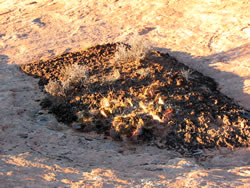
Cryptobiotic soil
garden
|
|
|