HIKING HAPPENINGS
July 2007
A Prize Winning
Show at the Amasa Back
by Marcia Hafner
 This
spring April did bring those showers and May gave us a banner
year for wildflowers, but the wildflower show doesn’t
last long. The summer heat brings this performance to a standstill
so I’m out there following The Amasa Back Trail for
a front row seat at this season’s bountiful crop. An
occasional breeze makes for a comfortable walk as I take
my time absorbing the wild splashes of color from the fiery
orange of the globemallow to the red tones of the Indian
paintbrush. There’s the yellow fringe of the Prince’s
plume, the passionate purple of the larkspur, and the soft
lavender of the Utah daisy. It is a treasure to find all
three cactus in bloom: the prickly pear, Whipple’s
fishhook, and Claret cup with hordes of insects wallowing
in that sweet nectar. The star performer, which has been
off-stage for several years, is the exquisite sego lily,
the state flower of Utah. In dry years, they are scarce and
I’d be lucky to find just a few. Now I am seeing them
by the dozens, many with a pinkish tone. This
spring April did bring those showers and May gave us a banner
year for wildflowers, but the wildflower show doesn’t
last long. The summer heat brings this performance to a standstill
so I’m out there following The Amasa Back Trail for
a front row seat at this season’s bountiful crop. An
occasional breeze makes for a comfortable walk as I take
my time absorbing the wild splashes of color from the fiery
orange of the globemallow to the red tones of the Indian
paintbrush. There’s the yellow fringe of the Prince’s
plume, the passionate purple of the larkspur, and the soft
lavender of the Utah daisy. It is a treasure to find all
three cactus in bloom: the prickly pear, Whipple’s
fishhook, and Claret cup with hordes of insects wallowing
in that sweet nectar. The star performer, which has been
off-stage for several years, is the exquisite sego lily,
the state flower of Utah. In dry years, they are scarce and
I’d be lucky to find just a few. Now I am seeing them
by the dozens, many with a pinkish tone.
The Amasa Back is named for the cattleman, George Amasa Larsen
(1866-1947), who arrived in Spanish Valley in 1880. It is
a three mile, cliff-sided ridge that forms a gooseneck hundreds
of feet above the Colorado River. With a gradual elevation
gain of more than 1000 feet, this jeep trail follows the
wide switchbacks of an old uranium exploration road. It is
a rough four-wheel drive road and on the downhill a dramatic
high flying ride over ledges for those on mountain bikes.
To get to the Amasa Back Trail, go south on Main Street and
turn right at McDonald’s on to Kane Creek Blvd. Drive
approximately five and a half miles to where the pavement
turns to dirt. To make a loop hike starting at the Jackson
Trail and down the Amasa back, stop at the open parking area
to your right. The beginning of the trail is not marked.
Look for it at the lower left part of the lot.
 For
access to The Amasa Back trailhead, which is clearly
marked, continue about a half mile and park at the
graded dirt parking lot on the right hand side. Then
take the short walk up the road to the beginning of
the trail. To get closer to the trailhead go beyond
the parking lot and find a pull-off along the side
of the road. The Amasa Back is a popular route for
jeepers and bicyclists and during the tourist season
it is a busy place. If you want to avoid the crowds,
do this hike in the winter! For
access to The Amasa Back trailhead, which is clearly
marked, continue about a half mile and park at the
graded dirt parking lot on the right hand side. Then
take the short walk up the road to the beginning of
the trail. To get closer to the trailhead go beyond
the parking lot and find a pull-off along the side
of the road. The Amasa Back is a popular route for
jeepers and bicyclists and during the tourist season
it is a busy place. If you want to avoid the crowds,
do this hike in the winter!
The beginning of the trail is a steep, rubbly drop down to
Kane Creek so watch your footing. Loose pebbles and sand
kicked up by so many vehicles make for poor traction.
At the stream crossing I glance over at a large alcove located
at the base of Navajo sandstone where there are some petroglyphs,
including a portrait of an owl. This is the only petroglyph
of an owl that I have ever seen. A closer look can be had
if you are willing to scramble up a heap of unstable rock.
The volume of water in Kane Creek varies depending on recent
rains and spring run-off. When it is high, it can be difficult
to keep your feet dry. Those on bicycles try to high-power
through before lost momentum can dump them in the water.
Today the water level is low enough to allow me to easily
jump from rock to rock to the other bank.
Every step of this trail has dramatic views, starting with
the tilted domes and finns of Behind The Rocks. Gradually
I lose sight of Kane Creek Road and start seeing the La Sal
Mountains. I can clearly see Manns Peak and Haystack Mountain
in the northern range, Mellenthin Peak and Mount Tukuhnikivatz
in the central section, and South Mountain at the very end.
 When
the trail starts to flatten out, I know I’m close
to the top. Straight ahead is the Amasa Back anticline
and to my left is the steep Jacob’s Ladder Trail
that goes down to the abandoned river meander of Jackson’s
Hole where John Jackson grazed his cattle and horses.
Several dead-end spur roads now make following the
trail confusing, but the main road forks to the north
of the base of the Amasa Back formation. At the crest,
the mountains shift out of view, and I’m looking
at the Wingate cliff formations on the north side of
the Colorado River along with a fantastic view of Deadhorse
Point State Park and Jackson’s Hole. I’m
also looking down on the blue evaporative ponds of
the still operating Potash Mine. When
the trail starts to flatten out, I know I’m close
to the top. Straight ahead is the Amasa Back anticline
and to my left is the steep Jacob’s Ladder Trail
that goes down to the abandoned river meander of Jackson’s
Hole where John Jackson grazed his cattle and horses.
Several dead-end spur roads now make following the
trail confusing, but the main road forks to the north
of the base of the Amasa Back formation. At the crest,
the mountains shift out of view, and I’m looking
at the Wingate cliff formations on the north side of
the Colorado River along with a fantastic view of Deadhorse
Point State Park and Jackson’s Hole. I’m
also looking down on the blue evaporative ponds of
the still operating Potash Mine.
Since I am making the loop hike down Jackson’s Trail,
which is not drivable for a jeep, I start my descent at the
power lines. Walking on a layer of Kayenta sandstone, my
viewpoint quickly changes to a long stretch of river and
the Poison Spider Trail and Mesa on the north side. Now I
can pick out my truck in the parking lot and I am once again
in sight of the majestic views of the La Sals and the twisted
landscape of Behind The Rocks.
This is a straight-forward, downhill trail. The more I walk,
the closer the river gets. Then I’m in dense sagebrush,
rabbitbrush, and greasewood with another crossing of Kane
Creek. When there is a high run-off, which usually occurs
in the spring, the water level can be waist higher or more,
but today the cool barefoot walk in ankle deep water is perfect
refreshment on this overly warm day. One last stretch of
tamarisk, one final, steep dirt scramble up and I’m
back at the truck.
|
Biological
Soil Crust (aka)
Cryptos (krip’ tose):
The surface of
Moab’s desert is held together by a thin
skin of living organisms known as cryptobiotic
soil or cryptos. It has a lumpy black appearance,
is very fragile, and takes decades to heal when
it has been damaged. This soil is a critical part
of the survival of the desert. The cryptobiotic
organisms help to stabilize the soil, hold moisture,
and provide protection for germination of the seeds
of other plants. Without it the dry areas of the
west would be much different. Although some disturbance
is normal and helps the soil to capture moisture,
excessive disturbance by hooves, bicycle tires
and hiking boots has been shown to destroy the
cryptobiotic organisms and their contribution to
the soil. When you walk around Moab avoid crushing
the cryptos. Stay on trails, walk in washes, hop
from stone to stone. Whatever it takes, don’t
crunch the cryptos unless you absolutely have to! |
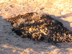
Cryptobiotic soil
garden
|
|
|