Hiking Happenings February
2007
Megatracks
by Rory Tyler
 |
Did you ever follow a dinosaur around?
No? Well, here’s your chance. Among Moab’s other
unique characteristics is a sprinkling of petrified tracks
left by the famous thunder lizards. Just off the top of my
head I can think of over a dozen local sites. Some of these
have just a few tracks or only a single imprint. Some have
more. And then there is the megatracks site on Copper Ridge.
Megatracks sites, as you’ve probably deduced, contain
dozens, if not hundreds of dinosaur footprints. They exist
in several places around the planet, commemorating whole
herds of the huge beasts passing by or milling about. Tracks
on top of tracks on top of tracks. That’s what it’s
like on Copper Ridge.
Dinosaur tracks come in two varieties, those left by sauropods
and those left by theropods. Sauropods were vegetarians that
walked on four big, round feet something like an elephant’s.
It’s hard to identify a sauropod track. Without well-defined
toe structures, they usually look like a large dimple in
the slickrock. Theropod tracks, on the other foot, are much
more obvious. Theropods, vegetarians and carnivores alike,
walked on their hind legs and had three well-defined toes
on their bird-like feet, which range in size from a few inches
to almost two feet.
The easiest place to see dino tracks is at Matrimony Springs
on Highway 128, the River Road, about two hundred yards from
its junction with Highway 191. Water from the spring actually
falls on one track of a three-step trackway. These prints
are about the size of your hand. The sandstone shelf to the
right of the spring contains at least a dozen bird-sized
tracks. Another well-known site is on Potash Road on some
limestone boulders just a few yards east of the Poison Spider
parking lot. Unfortunately, a few years ago somebody decided
they needed a latex mold of the tracks, leaving a lot of
gooey, white residue on the ancient footprints. Such behavior
is bad form and strongly discouraged. A few yards up the
hill is another set of tracks. There is also some Indian
rock art here. Over the years I’ve been struck by how
often I find Indian sign in the proximity of dinosaur sign.
Whether this is by accident or design is debatable, but I
favor the latter. Imagine what an Indian thought of bird
tracks set in stone and bigger than his head.
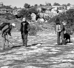
 Happenings readers tracking
dinosaurs on
Copper Ridge |
To get to the megatracks drive north
on Highway 191 for 26 miles and look for the BLM sign on
the right directing you to a track site. A dirt road goes
two miles to the base of Copper Ridge. Walk up the old four-wheel
drive road a hundred yards to two nice sets of tracks. One
of them is a rare sauropod trackway where the giant beast
made a right turn. The other, a little further up, is a theropod
trackway. An interpretive sign at the parking lot mentions
a megatrack site in Colorado but doesn’t take note
of the one a mile away. As the road goes up the hill you
can follow it to an old copper mine or turn into the valley
on the right, a more direct route to the megatracks. If you
stay in the valley, bear right and, at the top of the ridgeline,
turn right again and cross to the head of the next valley.
The megatracks are in the white caprock about a quarter mile
below the rim. (If you go to the copper mine you will need
to cross the head of the first valley before you drop down
to the megatracks.) The untrailed terrain is an attractive
mix of slickrock, wash bottom, and juniper woods, generally
mellow and easy to traverse.
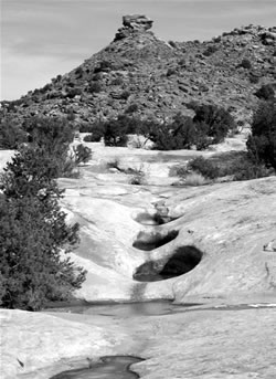
There are two major collections of footprints at the megatracks
site. Facing uphill, the largest group is in the extreme
upper left, or northeast corner, of the exposed rock. This
rock is rumpled and wrinkled from the hundreds of once-squishy
footprints that abound here. There is another set a little
further down the slope. Once you become familiar with the
pocks and pleats of the upper group the lower group will
be easy to spot.
To get back to your car you can stroll down this valley and
turn right when you get to the bottom of the ridge. If you’re
in a hurry you can go up to the tracks this way. It’s
the second valley south from the parking lot, but I like
doing this walk as a loop. Figure on two or three hours of
walking and more time for gawking.
Rory Tyler is available for cowboy
poetry/campfire song gatherings which include lore, science,
history and lies of the Moab area. (Suitable for all age
groups). Rates are negotiable. Give Rory a call at 435-260-8496.
|
Biological
Soil Crust (aka)
Cryptos (krip’ tose):
The surface of
Moab’s desert is held together by a thin
skin of living organisms known as cryptobiotic
soil or cryptos. It has a lumpy black appearance,
is very fragile, and takes decades to heal when
it has been damaged. This soil is a critical part
of the survival of the desert. The cryptobiotic
organisms help to stabilize the soil, hold moisture,
and provide protection for germination of the seeds
of other plants. Without it the dry areas of the
west would be much different. Although some disturbance
is normal and helps the soil to capture moisture,
excessive disturbance by hooves, bicycle tires
and hiking boots has been shown to destroy the
cryptobiotic organisms and their contribution to
the soil. When you walk around Moab avoid crushing
the cryptos. Stay on trails, walk in washes, hop
from stone to stone. Whatever it takes, don’t
crunch the cryptos unless you absolutely have to! |

Cryptobiotic soil
garden
|
|
|


