Hiking Happenings December
2006
Lower Seven
Mile
by Rory Tyler
It’s so deceptive. You’re
out for a walk. You pick out an interesting rock formation
in the near distance and start off. It looks close enough.
An hour…maybe two. What you don’t see is the
impassable chasm etched hundreds of feet into the desert’s
surface only a few minutes away. That could be Seven Mile
Canyon in your path. Where to now?
Lower Seven Mile Canyon is almost entirely in the Entrada
Sandstone formation. Entrada has three different components;
the Moab Member, the Slickrock Member, and the Dewey Bridge
Member. Lower Seven Mile is composed of the first two. The
Moab Member, a white layer of sandstone about fifty feet
thick, forms a nearly impenetrable barrier along the rim
of Seven Mile Canyon, which continues when Seven Mile meets
Courthouse Wash. Courthouse Wash is one of the main drainages
in Arches National Park and any walk along Seven Mile is
likely to lead you into this rarely visited part of the park.
The Slickrock member, below the Moab Member, is softer, redder,
and about 150 feet thick. It contains the main volume of
the canyon.
The lower reach of Seven Mile Canyon begins north of town
at the Highway 191 bridge, just south of the Hwy 191- Hwy
313 junction. If you park next to the highway you have to
cross a barbed wire fence. To avoid the fence, turn right
at the Bar M Chuckwagon road, then immediately left on the
two-track. Across the fence a dirt road leads you a couple
of hundred yards, passes a pipeline, then the canyon takes
a plunge.
The Seven Mile pour-off drops over a hundred feet to the
rocks below. During a good rainstorm it forms an impressive
waterfall. In the winter it can become a spectacular ice
wall. Except for an old cattle trail at the head of the canyon
the rim is prohibitively precipitous along its entire length.
This trail is about a hundred yards to the right of the pour-off.
Lower Seven Mile offers two interesting options. You can
take the cattle trail down into the canyon or you can stay
above the rim and putter about all day. (There are also some
rapeling anchors at the top of the trail if you want to get
some cheap thrills on a rope.)
If you stay on top you can go left or right of the pour-off.
There’s little chance, in either case, of getting disoriented
or lost. Left is as easy as it gets. The caprock is smooth
and almost uncut by side canyons. The views are delightful
and spacious. I prefer going right. You still get the great
views, but the caprock is a pure, stone-cut hodgepodge of
hills, humps, washes, cuts, and peculiar formations speckled
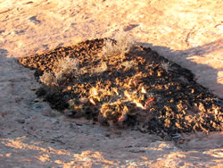
with elegant pockets cryptogamic garden and improbably twisted
junipers growing out of bare rock. It all lends itself perfectly
to miles of aimless, easy ambling. It takes about an hour
of east-trending zigzags to reach the rim of Courthouse Wash.
The views are spectacular. I’m especially fond of the
miles of hanging gardens growing out of the seep line between
the Moab Tongue and the Slickrock member.
For a very different experience go down the cattle trail.
Once inside you are completely cut off from the world above.
There’s no trail here, but the wash is wide and there
are only a few places where you have to clamber around some
brush or a set of bottom-choking boulders. The further you
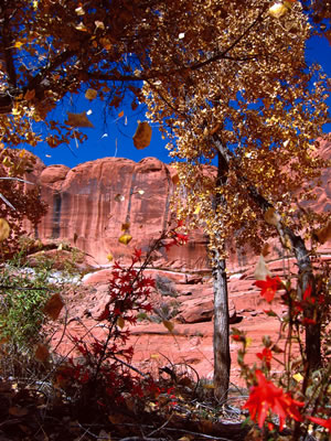
go the more deeply entrenched you become, surrounded by beautifully
eroded, sinuous walls of pastel pink and red sandstone. The
canyon can be shady in December, but there are plenty of
places where the sun comes pouring in. These pockets are
heat magnifiers and, if it’s a nice day, they’ll
be wonderfully warm and toasty.
The canyon wends its way about three miles to the confluence
with Courthouse Wash. Your options here are to go right,
left, or back from whence you came. The right hand path goes
down canyon about two miles to where the Park Road crosses
Courthouse Wash. If you leave another car here you can set
up an easy shuttle back to the Hwy 191 bridge. The left hand
path goes up canyon a couple miles where you’ll eventually
climb out of Courthouse Wash. This path can get a little
wet or icy, but it’s usually passable and well worth
the effort. Once you emerge, it’s two easy miles back
to Hwy 191.
Rory Tyler is available
for cowboy poetry/campfire song gatherings which include
lore, science, history and lies of the Moab area. (Suitable
for all age groups). Rates are negotiable. Give Rory a
call at 435-260-8496.
|
Biological
Soil Crust (aka)
Cryptos (krip’ tose):
The surface of
Moab’s desert is held together by a thin
skin of living organisms known as cryptobiotic
soil or cryptos. It has a lumpy black appearance,
is very fragile, and takes decades to heal when
it has been damaged. This soil is a critical part
of the survival of the desert. The cryptobiotic
organisms help to stabilize the soil, hold moisture,
and provide protection for germination of the seeds
of other plants. Without it the dry areas of the
west would be much different. Although some disturbance
is normal and helps the soil to capture moisture,
excessive disturbance by hooves, bicycle tires
and hiking boots has been shown to destroy the
cryptobiotic organisms and their contribution to
the soil. When you walk around Moab avoid crushing
the cryptos. Stay on trails, walk in washes, hop
from stone to stone. Whatever it takes, don’t
crunch the cryptos unless you absolutely have to! |

Cryptobiotic soil
garden
|
|
|

