Hiking
Happenings August 2005
Look to the
Mountains
by Rory Tyler
When it’s depressingly
hot and nasty in the canyons, the La Sal Mountains are
there providing shade and solace for sun-scorched eyes.
When thunderheads come rolling across the desert, the La
Sals are there, wringing the well-springs of the future
out of the stormy clouds. Few places in the world provide
a contrast  as
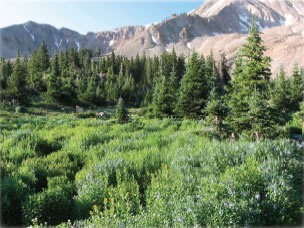
compressed, dramatic, or accessible as the sky-high gardens
of the La Sal Mountains floating far above the stark, stony
precipices of the canyon lands. Summer can be the hell-season
in Moab, but heaven is only a half hour away. as
compressed, dramatic, or accessible as the sky-high gardens
of the La Sal Mountains floating far above the stark, stony
precipices of the canyon lands. Summer can be the hell-season
in Moab, but heaven is only a half hour away.
The La Sal Loop Road provides the easiest access into the La Sal Mountains.
It makes a sixty-mile circuit from Moab, up to the mesas that skirt the
peaks, and back down to the canyons. Any basic area map will show you
how to get to the Loop Road. If you access the Loop Road by going south,
it meets the Geyser Pass Road about twenty miles from town. The Geyser
Pass road crosses the range 10,500’ above sea level, while Moab
is at a mere 4,000’. (On a map, the La Sal Pass Road, where it
leaves the Loop Road at Pack Creek, might look like a tempting way to
access the southern part of the range. However, if you value the integrity
of your vehicle’s suspension, not to mention your lower lumbar,
I suggest going the long way round through the town of La Sal, thus avoiding
a long, rude, brutal four-wheel ordeal.)
Any side road, sidetrack, or trailhead along the Loop Road will provide
a fine excursion, but my favorite hikes start along the Geyser Pass Road
and at Warner Lake. It’s seven miles from the Loop Road up to the
Warner Lake Campground at 9,200’. The lake, a small reservoir,
is surrounded by vibrant meadows, a leafy aspen canopy, massive granite-shouldered
mountains, and squadrons of mosquitoes and Boy Scouts who are so happy
you’ve come. Bug dope will help in one instance, but not the other.
The reservoir is fed by a chipper little flower-lined stream that tumbles
its way down six miles and 1,500 ‘ from Burro Pass.
For an intensely aerobic option, consider the Dry Fork spur three miles
from the trailhead. If you’re in slow mode, just amble under the
trembling canopy of quaking aspens, enjoy the lacy emerald light, and
scan tree trunks for various man-and-animal-made markings. This has been
a popular place for people to carve their names, initials, and vows for
over a century. Many of the Hispanic names belong to herders from the
old days, when it was the summer grazing capacity of the mountains, not
the winter desert grazing, that limited herd size in the region. You
can also find scrapes where winter elk gnawed the bark off the white
aspen boles, and even a tree or two that registers the memorial claw
marks of a bear cub scampering his way to safety.
The Geyser Pass Road has several terrific hiking options. The first is
the Trans-La Sal Trail, three miles from the Loop Road turn-off. The
trail goes north (Boren Mesa) and south (Squaw Springs) from the car
park. The northern spur takes you to Oowah and Clark Lakes, two more
small reservoirs, but neither as scenic as Warner. The south spur isn’t
as vertical, but seems a little wilder as it passes through some very
primeval canyons, meadows, and canopies.
The Gold Basin turn-off is 5.5 miles from the Loop Road. The Gold Basin
Trail follows Brumley Creek two miles up into a glacier-carved cirque
surrounded by the highest summits of the La Sals. About two hundred yards
from the trailhead you cross a fallen aspen. As soon as you cross it,
take the trail to the left. This is an outstanding place to meet up with
such local luminaries as elk, deer, bear, weasels, and walkers. If you’re
interested in bagging a peak or two, use the trailhead at Laurel Meadows,
.8 miles from the Geyser Pass Road intersection. This puts you on Brumley
Ridge, then on to Mounts Mellenthin and Peale. It’s all very straightforward.
It’s fun to come down the grassy avalanche chutes into Gold Basin,
but don’t try the scree slope on Mel’s northwest side unless
you’re doing primary research on the angle of repose in Tertiary
batholithic exfoliates…and I bet you aren’t. If you get
up to the peaks, the ridgeline west to Mount Tukhanikavats (just say
Took) is doable, but problematical. Leave the dog.
At Geyser Pass, turn left to Moonlight Meadows. These many acres of spring-fed
lees get heavy rotation from bovines and bikers alike, but they’re
still well worth a visit. There is also a trailhead near here for Burro
Pass. An avalanche demolished the trail on the north side of the ridgeline,
but this is still a good way to ascend Haystack Mountain.
Now, to change the subject slightly… “Look to the Mountains” is
one of the best books about western land use I’ve ever read. It’s
a no-nonsense history of the Manti–La Sal National Forest by Charles
Peterson. (It’s where I learned about grazing patterns in the La
Sals.) Published in 1975, it’s out of print now, but there’s
one in the library if your car broke down in Moab and you need to shade-up
for a few days. By the way, if your car did break down in Moab, welcome
to your new home! If you long for your own copy, used ones carry a premium
price, but I have it on good authority that a deal can be struck with
a certain local book-monger.
Peterson writes, “While I have focused primarily upon the development
of the Forest, I have been concerned also with the character of the society
that depended on the Forest, and have attempted to understand the interrelationships
of society and forest.” And he succeeds nicely. This article isn’t
about Peterson’s history, of course; it’s about hiking in
the La Sal Mountains. But, since I’m stealing his title, I confess
my crime forthwith and apologize by paying homage to his valuable work.

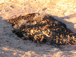
Cryptobiotic soil
garden
|
Rory Tyler is available for cowboy
poetry/campfire song gatherings which include lore, science,
history and lies of the Moab area. (Suitable for all
age groups). Rates are negotiable. Give Rory a call at
435-260-8496.
|
 as
compressed, dramatic, or accessible as the sky-high gardens
of the La Sal Mountains floating far above the stark, stony
precipices of the canyon lands. Summer can be the hell-season
in Moab, but heaven is only a half hour away.