 Ken’s Lake Recreation Area southeast of Moab features several trails including those to the lake, The Rock, and Faux Falls. On this particular summer morning, I head out to sample the rejuvenating negative ions of the falls. These ions are charged particles that are invisible and odorless, but, wow, when I inhale them next to waterfalls and oceans, I feel a lift due to the biochemical reaction that increases my levels of serotonin, a neurotransmitter that enhances well-being. I offer two options for getting to this natural bliss. Ken’s Lake Recreation Area southeast of Moab features several trails including those to the lake, The Rock, and Faux Falls. On this particular summer morning, I head out to sample the rejuvenating negative ions of the falls. These ions are charged particles that are invisible and odorless, but, wow, when I inhale them next to waterfalls and oceans, I feel a lift due to the biochemical reaction that increases my levels of serotonin, a neurotransmitter that enhances well-being. I offer two options for getting to this natural bliss.
Route 1: Proceed south on Main Street/Highway 191 for about 7.8 miles and turn left (north) onto Old Airport Road. After about half a mile, Old Airport ends at Spanish Valley/La Sal Mountain Loop Road. Turn right (east) and drive another .08 miles, then turn left (north) at the sign for Ken’s Lake onto County Road 175.
 Route 2: From Center and Main Streets, proceed east to 400 East, then turn right (south) to Sand Flats Drive, turn left (east), and proceed to the stop sign. Turn right (south) onto Mill Creek Drive. Make a soft, curving left at the Y onto Spanish Valley Drive until the turnoff to Ken’s Lake. Route 2: From Center and Main Streets, proceed east to 400 East, then turn right (south) to Sand Flats Drive, turn left (east), and proceed to the stop sign. Turn right (south) onto Mill Creek Drive. Make a soft, curving left at the Y onto Spanish Valley Drive until the turnoff to Ken’s Lake.
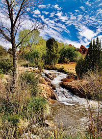
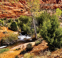
As I turn towards the lake, the falls are immediately visible. The French word faux, pronounced “foe,” means not genuine, or, in this case, manmade. The snow melt that feeds this oasis is diverted from Mill Creek up at Flat Pass, through the 645-foot-long Sheley Tunnel, and churns wildly down a rock-lined pinball machine, eventually pouring into the southeast corner of the lake. Horace Sheley started this project decades ago to irrigate Spanish Valley’s alfalfa fields, fruit trees, and even wine grapes. The lake has a surface area of 86 acres and is 2,690 feet long, 1,400 feet wide, and 70 feet deep. Formally known as the Kenneth Eugene McDougald Reservoir, the eponymous Ken was chairman of the Grand County Water Conservancy District and served as Moab’s mayor during the town’s uranium boom of the 1950s and ‘60s. The lake is surrounded by terra-cotta Navajo formation fins to the east and blackbrush (its branches gray when dry, black when wet) to the south and west. Along the creek, Fremont cottonwoods, singleleaf ash, Gambel oak, juniper, and pinyons greet hikers, while paintbrushes flash scarlet along the hills and roadsides.
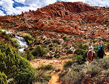
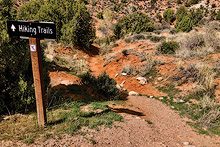
 Mark, the camp host, suggests I park next to the information kiosk at the entrance to the Campsite Loop B entrance (sites 39 to 48). Shortly after entering the hiking corridor, I see a short bridge of wooden planks that crosses the creek and connects to hikes around the lake and The Rock. Instead, I go right, sharing the sandy, humpty-bumpty route uphill along the creek with poets, laughing children, and even riders on horseback. I occasionally look back to view the snaggle-toothed landforms of Behind the Rocks and the towering, cinnamon wall of the Moab Rim. To the right, South Mountain pokes its snow-streaked head into the cerulean sky. You can hike to the lower falls as an out-and-back along the creek, or as a loop by returning by road to the campground. Mark, the camp host, suggests I park next to the information kiosk at the entrance to the Campsite Loop B entrance (sites 39 to 48). Shortly after entering the hiking corridor, I see a short bridge of wooden planks that crosses the creek and connects to hikes around the lake and The Rock. Instead, I go right, sharing the sandy, humpty-bumpty route uphill along the creek with poets, laughing children, and even riders on horseback. I occasionally look back to view the snaggle-toothed landforms of Behind the Rocks and the towering, cinnamon wall of the Moab Rim. To the right, South Mountain pokes its snow-streaked head into the cerulean sky. You can hike to the lower falls as an out-and-back along the creek, or as a loop by returning by road to the campground.
Among the fauna in this area, I often see Eastern collared lizards (Crotaphytus colliarisi) in the summer. These turquoise-and-yellow reptiles have dark neck collars and are one of the few (including Mexico’s basilisk lizards) that run on their hind legs. They can also appear to pose as they freeze in place to look for grasshoppers and other insects. So enjoy voguing lizards and breathe in the negative ions infusing the waterfall’s spray in this magical place. .
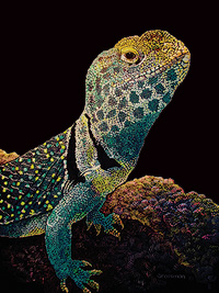 Collared Lizard scratchboard
Kathy Grossman grew up a mile from the negative ions of Pacific Ocean spray and now hikes, writes, and makes art in Moab. Her original “Collared Lizard” scratchboard hangs in the Moab library on the east wall facing the Large Print section.
|