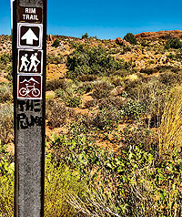
 Mill Creek Canyon’s rims rise east of Moab to the north and south of Mill Creek. The Dump Wall Trail ends at an overlook of the creek from its north rim. The hike-and-bike Mill Creek Rim Trail follows the creek’s south rim. This top section of the Mill Creek Rim Trail is more defined than the rocky approach corridor. (The descent of this same section is colloquially called “The Plunge.”) The rim trail starts from the Mill Creek Canyon Trailhead, east off Main Street to 400 East. Turn left (east) at Dave’s Corner Market onto Mill Creek Drive and proceed right at the three-way stop. After a half mile, turn left (east) onto Powerhouse Lane to the parking area. The trail up to the rim traverses southeast above the spillway. Mill Creek Canyon’s rims rise east of Moab to the north and south of Mill Creek. The Dump Wall Trail ends at an overlook of the creek from its north rim. The hike-and-bike Mill Creek Rim Trail follows the creek’s south rim. This top section of the Mill Creek Rim Trail is more defined than the rocky approach corridor. (The descent of this same section is colloquially called “The Plunge.”) The rim trail starts from the Mill Creek Canyon Trailhead, east off Main Street to 400 East. Turn left (east) at Dave’s Corner Market onto Mill Creek Drive and proceed right at the three-way stop. After a half mile, turn left (east) onto Powerhouse Lane to the parking area. The trail up to the rim traverses southeast above the spillway.
On a recent, clear, still, fall morning, a fingernail moon hanging in the west and the sun still behind the La Sals, I climb up toward the rim, turn left at the Y, and skirt the pits gouged out from August 2022’s floods. (The original wooden mill that gives the creek its name was destroyed in August 1919’s floods.) On this trail, I’m exposed to all that Mother Nature throws at me, from gusty winds to monsoon rains. And the sun! Except for occasional juniper trees, shade is scarce, so wear a wide-brimmed hat. This trail can also be quite delightful after a nighttime drenching and even during daytime drizzles.
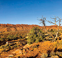
Striding along this out-and-back humpy mix of hills and dales, the washes and sandy crests are blown smooth from last night’s winds, prints of rodents and birds erased, the coolness pure bliss. A signed hikers-only spur off the main trail takes you to overlooks of the junction of Mill Creek’s North and South Forks, offering views of the spectacular riparian oasis below. But don’t only look down. This trail boasts 360 degrees of spectacular views, from mountains to sandstone bluffs to our verdant little town. Visitors to Moab, be amazed! Locals, be reminded of why you moved here. And why you stay. And those born and raised here in Moab, call the publisher of Moab Happenings, Theresa King, and she will take you to lunch.
The rim trail might also be made into a loop by way of Mill Creek’s “Right Hand,” (the creek’s south fork), or a one-way foray with a shuttle pick-up via North Highland Drive.
The rim trail’s history is also intriguing. A combination of an old, closed, Jeep road and the Old Mail Trail, this was once a web of horse trails used to carry documents, letters, and supplies to area ranchers and miners in the late 1800s and early 1900s. Numerous routes and trails faded away, and some became better groomed for horse travel. The southern end of Moab Valley—once called Plainfield, later Poverty Flats, now Spanish Valley—established its first official mail route in 1879. The town of Moab got its first post office in 1880. The Old Mail Trail morphs into a paved road and continues south to Murphy Lane. Thanks to Mary Langworthy of the Moab Museum and the #37 issue of Canyon Legacy at our library for information on Moab’s postal history.
To hike the Mill Creek Rim Trail in hotter conditions, start early. In addition to carrying water, you could pack your breakfast, such as a Breakfast Burrito from Milt’s or perhaps a Moab Mania Panini from Sweet Cravings. Or perhaps, you could make do with Trail Mix Bar from Dave’s Corner Market. However you choose to fuel your journey, this athletic trail is superb all seasons of the year.
Kathy Grossman is a southern California native, a cartoonist and writer, and lover of deserts. Now living between Mill and Pack Creeks, she has been in Moab since 2011.
|