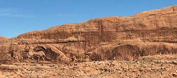
 The “Dump Wall” is a fairly easy out-and-back hike along a Jurassic cliff band east of Moab. The end or “goal” is an overlook down into Mill Creek Canyon. You can also view the Solid Waste Special Service District #1 Moab Landfill, previously called the “Moab dump.” (Our household trash is now taken to the Klondike Landfill north of town.) You can take several routes to the overlook, along the cliff wall or through a sandier lower section. The La Sals, the city of Moab, and the confluence of the North and South Forks of Mill Creek are all part of the viewscape. So, what about that dump? The “Dump Wall” is a fairly easy out-and-back hike along a Jurassic cliff band east of Moab. The end or “goal” is an overlook down into Mill Creek Canyon. You can also view the Solid Waste Special Service District #1 Moab Landfill, previously called the “Moab dump.” (Our household trash is now taken to the Klondike Landfill north of town.) You can take several routes to the overlook, along the cliff wall or through a sandier lower section. The La Sals, the city of Moab, and the confluence of the North and South Forks of Mill Creek are all part of the viewscape. So, what about that dump?
 The view from our landfill is scenic. So scenic, in fact, that it tied with Kodiak, Alaska’s dump as most scenic in a Chamber of Commerce survey in 1986. At Moab’s landfill, workers regularly scoop and smooth everything into artistic hillocks, such as with my partner’s and my recent piles of withered flowers and wind-downed poplar branches. I love our dump. The view from our landfill is scenic. So scenic, in fact, that it tied with Kodiak, Alaska’s dump as most scenic in a Chamber of Commerce survey in 1986. At Moab’s landfill, workers regularly scoop and smooth everything into artistic hillocks, such as with my partner’s and my recent piles of withered flowers and wind-downed poplar branches. I love our dump.
In February, the cliff band catches and reflects heat and light in the afternoon, just when Moabites, weary of the drear, need heat and light. And maybe also just when a visitor who didn’t realize February would be so darn cold in Moab needs them. The cliff also contains rock art. Ancient ones scratched, pecked, picked, and chiseled petroglyphs of spirals, snakes, sheep, and human figures.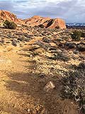
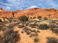
From the overlook, looking right (southwest) from the confluence, you’ll see Mill Creek winding toward town and the Colorado River. You’ll also be looking towards Spanish Valley, the southern portion of the Moab Valley.
A nature-journal watercolorist will definitely use a palette of neutrals this time of year, choosing ochres, grays, creams and buffs, muted silvers, and burnt siennas. The only greens will be the redoubtable junipers dotting the moraines and hillsides. If you and your Valentine bring your colored pencils on this hike, pop those rock colors with maroon, butterscotch, violet, peach, mocha, crimson, and caramel. Our geology is like a box of chocolates: around each corner is a new color surprise.
To get there. From Center Street, go to 400 East (in Utah-speak, that’s “4th East”), and turn east at Milt’s Stop & Eat and Dave’s Corner Market. You’ll see signs for the Slickrock Bike Trail and the Recycle Center. Continue to the stop sign, then proceed straight along Sand Flats Road to the entrance to the landfill. A half-mile beyond the landfill is the sand-and-gravel parking area on the right side of the road. If you reach the entrance station to Sand Flats, you’ve gone too far.
On your way, you might stop at Dave’s for trail mixes, pastries, and some wonderful coffee, though be aware the Dump Wall parking area has no toilet facilities. And don’t forget the clementines (California mandarin oranges). They’re in season right now, shipped from California’s Central Valley November through March. (And pack out those peels.)
The La Sals are festooned with snow right now, the color values of the rocks and dunes are beautifully deepened, and the sand will likely be nicely compacted from recent rainstorms. You can also spot the gang at the landfill below keeping our town clean and tidy. Bravo!

A southern California native, Kathy Grossman first fell in love with the desert
at age seven on her first camping trip in Anza-Borrego Desert State Park.
For more Moab hiking information, check out Back of Beyond Books,
the online “Hiking Happenings” archives of Moab Happenings,
or the 917.9 section at our beloved library.
|