Scenic Roads Happenings January 2010
Potash Road
By Rob Cassingham
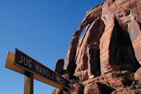 Jug Handle Arch, Mile 13.3
 |
The Potash Road (Utah Highway 279) was originally constructed both to serve the potash mine 15.3 miles downcanyon, and as a connecting road for a planned highway (Utah 278) that was to have provided access to Dead Horse Point State Park. Though Utah 278 was never constructed (Utah Highway 313 having been built instead), the Potash Road continues to serve the potash mine. Semi trucks are a semi-common sight on this road, so visitors should remain alert to big truck traffic. Stopping in the middle of the road to gawk at the scenery is not a good idea!
To access the Potash Road, start at the intersection of Main and Center streets, at the Moab Information Center. Drivers interested in following the Potash Road past the potash mine and into Canyonlands National Park should stop at the information center and inquire about the latest road conditions.
Drive north on Main Street (US 191) 4.0 miles to the intersection of Utah 279 and US 191. Turn left on 279, and reset your trip meter.
There are restroom facilities at miles 4.0, 5.5, 5.9 and 9.9.
Mile 0 Start of Utah 279 (the “Potash Road”).
Over the next .5 mile, you will be passing the tailings pile for the old Atlas uranium mill. Originally constructed by the ‘Uranium King of Moab’ Charlie Steen in 1957, the mill processed raw uranium ore into a more concentrated ‘yellowcake’, which was then shipped for further refinement into nuclear weapons and fuel rods for reactors. When the mill was shuttered in 1984, the pile of tailings had grown to cover 130 acres to a height of 110 feet. This mildly radioactive pile has been leaching chemicals (primarily ammonia and various acids that were used in the refining process) into the Colorado River for decades. As over 20 million people downriver depend on the Colorado’s water, removing the tailings pile became a pressing need. After many years of wrangling to get federal money to remove the pile, the first load of tailings was removed on April 20, 2009. The tailings are loaded into steel containers and hauled to the railroad tracks across the highway from the pile. Then the containers are loaded onto the train and transported 30 miles north to a specially prepared disposal site. It is expected to take over 15 years to completely remove the toxic eyesore.
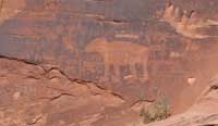
Fremont bear petroglyph, Mile 5.1
Fremont petroglyph, Mile 5.1
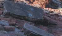
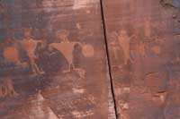
dinosaur tracks on sandstone slab, Mile 5.9
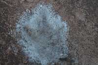
detail of dinosaur track, Mile 5.9
|
Mile 2.7 You are entering “The Portal”. The river is leaving the Moab valley and entering a canyon gorge. From this point until below Lake Mead, the river remains bounded by canyon walls, including the Grand Canyon.
Mile 4.0 Jaycee park offers several choice tent-only campsites.
Mile 4.2 Over the next mile, the road passes through an area rock climbers call “Wall Street”. There are often vehicles parked on the shoulder, and rock climbers scaling the cliffs. Due to the occasional congestion, the speed limit drops to 35 mph. Drive cautiously!
Mile 5.0 There are many petroglyphs on the right, located 10-20 feet above the road level. Attributed to the Fremont culture, they were likely carved approximately 1000 years ago. One of the more common questions asked about this panel involves how they managed to carve them so high above ground level. The answer is that there used to be a pile of stone rubble that the Fremonts stood on. When the Potash Road was constructed 1963, the rubble pile was bulldozed away. This had the happy side effect of protecting the panels from vandalism.
The ancient images are better viewed and photographed in the afternoon shade.
Mile 5.1 This panel of Fremont petroglyphs (located just off the pile of stone rubble) is not nearly as large as the prior rock art site, but there is a large and splendid image of a bear, including ears and toes.
Mile 5.5 Williams Bottom camping area
Mile 5.9 The trailhead for the Poison Spider trail is on the right. This very rugged route is popular with mountain bikers and jeepers. There is also a large rectangular slab of dark sandstone that contains several theropod (three-toed predator) dinosaur tracks upon the surface. The stone slab can be viewed from road level, or by scrambling up to the tracks.
Mile 9.9 On the right is the parking area for the Corona Arch hiking trail. This moderately strenuous trail (3 miles/4.8 km round trip, 440 feet/134 meters) leads to spectacular Corona Arch, which rivals any arch in Arches National Park for grace and beauty. There is an informational kiosk here that displays the map for the hiking route.
Across the highway from the trailhead is the recently constructed Gold Bar Recreation Area, suitable for group camping, and large motorhomes.
Mile 13.3 Jughandle Arch on the right.
Mile 13.4 The entrance to Long Canyon on your right. This 4x4 route ends near the entrance to Dead Horse Point State Park. The road is easier when taken from the top down, but if you choose to drive this route, under no circumstances should you drive it when wet or snow covered. The road surface in the upper half of the canyon becomes VERY slick, and the author of this article can testify from personal experience that the road, when wet, quickly becomes a sphincter-clenching ordeal.
Mile 15.3 You arrived at the potash mine buildings, and the end of the road log. The potash mine has been extracting potash (commonly used in fertilizer) and salt from the subsurface Paradox salt deposits for nearly 50 years. Originally, the salt and potash was extracted conventionally from mine shafts. In 1963, an explosion in the 2,700 foot/823 meter mine (at the time, the deepest mine in the country) killed 18 miners. Since then, potash and salt have been extracted by pumping water into the old mine shafts, then pumping the water to several vast evaporation ponds (which are clearly visible from Dead Horse Point State Park). As the water evaporates, it leaves behind the salt and potash, which is then scraped up and prepared for market.
This is the end of the road log. Please return to Moab by reversing this route.
If you continue following the Potash Road farther, it becomes a dirt road in another 1.3 miles, it becomes a 4x4 road, which will lead you in 12.6 miles to the boundary of Canyonlands National Park. Another 2.4 miles, and the Potash Road will intersect with the Shafer Trail (generally closed to winter travel-check with the Moab Information Center for info regarding road conditions). Another 5.3 miles up the thrilling (and not for those afraid of heights) switchbacks of the Shafer Trail will take you back to pavement within Canyonlands NP.
Thank you for visiting! The Moab Happenings wishes you a wonderful 2010, and encourages you to explore all that Moab has to offer. |