Scenic Roads Happenings December 2009
Sego Canyon Rock Art Panels
By Rob Cassingham
In the vicinity of Moab, there are dozens of rock art panels left by several different Native American cultures. Three of the best panels, from three different cultures (Ute, Fremont and Barrier Canyon), are located within 150 feet of each other in Sego Canyon, 41 fast and easy miles northeast of Moab. Please note that these panels are still considered sacred to Native Americans. Treat the site with respect, and PLEASE do nothing more than photograph the ancient images.
For those uninterested in reading the full road log below, the directions are simple enough: Drive north on US Highway 191 until you intersect Interstate 70, then head east 5 miles to the next exit (Thompson Springs). Exit the freeway, and at the bottom of the off ramp, head north. When the paved road becomes a dirt road, you passed the parking area .1 mile behind you. Park near the pit toilet and enjoy!
For those interested in a more detailed road log, read on…
To start your drive, proceed to the Moab Information Center located at the intersection of Main and Center Streets and reset your trip meter.
Mile 0 Main and Center streets. Head north on Main Street, which will eventually become US 191.
Mile 2.5 Continue north at this intersection. The road to the right is Utah Highway 128. This extremely scenic drive was detailed in the October 2009 issue of the Moab Happenings. If you are interested in this road (or other scenic drives), you may view the article at moabhappenings.com and click the Article Archive link.
Scroll down the page to Scenic Roads.
Mile 2.6 The highway crosses over the Colorado River.
Mile 3.1 The canyon to the right is Courthouse Wash. It is a beautiful hike. Hiking the canyon for 6.5 miles will take you to the park road inside Arches National Park.
Mile 4.0 The Potash Road (Utah Highway 211) heads west at this point. The Potash Road will be detailed in the February issue of the Moab Happenings.
Mile 4.5 The entrance to Arches National Park is on the right.
Mile 5.0 There is a bit of interesting geology at this point. On the left side of the highway, cliffs tower high above the road. These cliffs are composed of Wingate sandstone. There is just the thinnest remnant of Kayenta sandstone topping these cliffs. In this area, Kayenta in normally 100-200 feet thick, but most of it has eroded away. Above the Kayenta should be 500-800 feet of Navajo sandstone, but that has also eroded away. On the right side of the highway, the light colored sandstone at road level is Navajo sandstone. All of the geologic layers on the left have been thrust upwards. All of the layers on the right have dropped down. This is due to a massive (and fortunately inactive) ancient fault. The total displacement (lifting and dropping) from the left side of the road to the right side is over 2,400 feet.
Mile 5.3 As the road curves past a narrow spot, you may notice evidence of the massive faulting recorded in the grey limestone cliff to the left.
Over the next several miles, the highway ascends through Moab Canyon. The striking dark red rock formations on the left are Permian-era Organ Rock shale. This is the same type of rock found in the Narrows of Onion Creek. That drive was detailed in last month’s (November) issue of the Moab Happenings.
Mile 11.4 Continue heading North. Utah Highway 313 heads west at this point, providing access to Dead Horse Point State Park and Canyonlands National Park.
Mile 12.4 Willow Flats road to the right. This was the original access road into Arches National Monument until the early 1960s. It reaches the main park road at Balanced Rock. A high-clearance vehicle is recommended for this route.
Mile 13.9 Dalton Wells on the right. A historical marker just off the road details the history of a large Civilian Conservation Corps camp here in the 1930s, as well as a shameful period where the old camp buildings were used for several months in 1943 as an internment camp for Japanese Americans deemed troublemakers at other internment camps.
Mile 15.4 Mill Canyon to the left. This road will take you to a self-guided hike to several dinosaur fossils. The road will be detailed in the January issue of the Moab Happenings.
Just beyond this point, the highway crosses Courthouse Wash. This is the very same wash you passed at mile 3.1.
Mile 16.5 The road to Klondike Bluffs is on the right. The road is for high-clearance 4x4 vehicles, and leads to dinosaur tracks. It will be detailed in the January issue of the Moab happenings.
Mile 18.0 Moab’s airport, Canyonlands Field, is on the left.
From this point on, all the soft grey deposits to the west are Mancos shale. It was left behind as sea floor deposits over 90 million years ago. In some areas of Mancos shale, one may find fossilized oyster reefs, and if you are lucky, the rare shark’s tooth may be discovered.
Mile 23.0 On the right is an access road to the Copper Ridge dinosaur tracks. This road will also be detailed in next month’s (January) Moab Happenings.
Mile 26.2 Although nearly no evidence remains, this was once the location of Valley City, a small settlement that existed thanks to a small earthen dam built to trap rainfall runoff in nearby Thompson Wash. Heavy thunderstorms caused the dam to fail several times, flooding the community. By the 1940s, all residents had moved on.
Mile 31.4 Milepost 157. Interstate 70. Head east on the interstate.
The cliffline to the north of I-70 is the Book Cliffs. They are the longest escarpment in the world, stretching over 240 miles in length.
Mile 36.4 Exit 187, Thompson Springs. Take this exit. At the bottom of the off ramp, reset your trip meter and turn left, heading north.
Mile 1 Main Street, Thompson Springs. The cross street is the former US Highway 6. When I-70 bypassed Thompson Springs, the small core of the town died, and Thompson has been in decline ever since. The small café to your left was used in a scene of the movie Thelma and Louise.
Thompson Springs was established so the Denver & Rio Grande Railroad steam locomotives could take on water to fill their boilers. Later, high quality coal was discovered just a few miles north of Thompson. With the locomotives needing a steady supply of coal, the town of Sego was established to fill this need.
Thompson was once critical connecting Moab to the outside world. All freight and passengers bound for Moab left the train here and were transported via freight wagon or stagecoach.
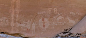
This panel was carved by Ute Indians.
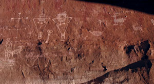
Attributed to the Fremont Culture,
this panel may be 1000 years old.
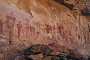
These striking and ghostly images
were painted over 3000 years ago.
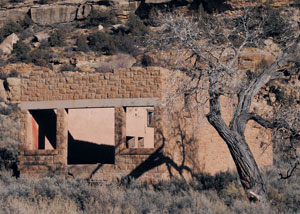
The stone walls of the Sego Mine Company store still stand tall.
|
Continue driving north at this intersection.
Mile 1.3 Thompson’s old one-room schoolhouse still stands to the right.
Mile 4.4 There is a pullout to the right, with a BLM pit toilet. This is the location of the Sego rock art panels.
The first panel is adjacent to the parking area. It is a Ute culture petroglyph (meaning carved or pecked onto the rock surface) panel. This panel is of historic age, as evidenced by the presence of riders mounted upon horses.
The second panel, approx. 100 feet to the right of the Ute panel, is attributed to the Fremont culture approx. 1,000 years ago. The images have been carved over much older Barrier Canyon culture red pictographs (a pictograph is painted upon the stone).
The third panel, just around the corner from the Fremont panel, is a spectacular Barrier Canyon culture pictograph panel. These amazing images are easily 3,000 years old and possibly much older.
Mile 4.5 Cattleguard. The road becomes dirt. There is a small corral to the right. More pictographs and petroglyphs are found here. Unfortunately, they have been vandalized, but are still well worth a look.
Mile 5.0 There is a sign noting Sego Canyon to the right. Turn here.
Over the next mile, you will notice bridges and abutments crossing the wash. These were built for the narrow gauge railroad that once hauled coal from the town of Sego to the waiting locomotives down in Thompson Springs.
Mile 6.0 There is a large parking area near the fast-collapsing ruins of the wooden boarding house. Ostensibly built to house bachelor coal miners, rumor has it that it was actually a brothel. Some of the rooms still show walls painted lavender and sea foam green-generally not colors that rough coal miners would choose for themselves! This structure is very unstable-PLEASE do not enter it. Final collapse could happen at any time.
The imposing stone building across the road was once the old company store.
Coal was discovered here in 1908, and a community was quickly established. In 1930, there were 200 residents of Sego, and the mine was producing 1,500 tons of coal a day. The advent of the diesel locomotive spelled the end of Sego, and by 1950 it was virtually abandoned. The great uranium boom of the 1950s in Moab caused a great housing shortage, so most of the buildings in Sego that could be moved were transported to Moab. This explains why there are so few obvious remnants of a once-thriving town present, although there are a few rough stone dwellings scattered farther up and down canyon.
The Moab Happenings thanks you for visiting, and please return to Moab often! There are many more fascinating and spectacular drives awaiting your discovery. |