Scenic Roads Happenings November 2009
Onion Creek
By Rob Cassingham
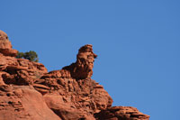
The Poodle
The Camel
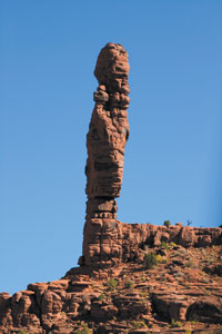
The Candlestick
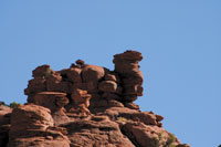
Right to Left: Big Bad Wolf, Little Red Riding Hood, The Chessmen
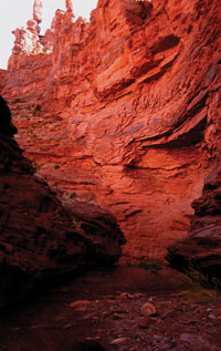
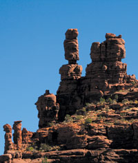
Onion Creek Narrows
|
The Moab area offers dozens of spectacular drives, from highways to rough 4x4 routes passable to only the most rugged of off-road vehicles. While most of the drives offer sweeping vistas and breathtaking panoramas, trails that allow the visitor to get extremely up-close and intimate with the land are largely restricted to the four-wheeler crowd. This fact is what makes Onion Creek a rare treat: A well-maintained dirt road, normally passable to carefully driven highway vehicles, winds sinuously through a narrow brick-red canyon crowded with bizarre, fantastic and amazing rock formations. This route affords the casual visitor an experience and views seldom enjoyed by the majority of Moab’s visitors.
Please be aware that this road may be impassable to highway vehicles during and after storms. In addition, oncoming traffic is a common occurrence-combined with blind corners and an oft-narrow road, visitors are advised to adjust their speed accordingly.
The road frequently crosses the shallow stream (less than 4” deep). This water contains much salt and arsenic, so wash your car’s undercarriage as soon as possible.
To begin this road log, start your trip at the intersection of Main and Center Streets, at the Moab Information Center. Drive north on Main Street 2.4 miles to the intersection of US Highway 191 and Utah Highway 128 (“The River Road”). Turn right on the River Road (which is detailed as a scenic drive in the October 2009 issue of the Moab Happenings), and proceed 20.2 miles to the intersection of the River Road and the Onion Creek Road. Turn right onto the Onion Creek Road, and reset your odometer.
Mile 0.0 The route starts at the intersection with Utah Highway 128 and heads south. A splendid panorama is laid out before you. Fisher Towers is to the left, Fisher Mesa looms directly in front, and the spires of Castleton Tower and The Priest and Nuns is in the distance to the right.
Mile 0.6 There are several large group campsites to the left, and a parking area used by many as a staging area. This is a very popular route with a diverse group of recreationalists (mountain bikers, motorcycle riders, ATVers, horseback riders, hikers, Jeepers) so please drive courteously and watch your speed, especially on blind curves.
Just beyond this point, Onion Creek comes into view on the left for the first time.
Mile 1.0 The road crosses Onion Creek for the first time. Over the next 5.1 miles, you will be crossing it another 24 times!
Again, a reminder: This water is corrosive, so cross the stream slowly in order to minimize splashing, and treat your vehicle to an undercarriage wash when you return to Moab.
Mile 2.5 Onion Creek has cut through the Permian-era (approx. 280 million years ago) dark reddish-brown sandstones and mudstones of the Cutler formation. This stone weathers into many fantastic and unusual forms that will challenge your imagination. On the skyline above the road is rock weathered into a form resembling a poodle.
Mile 2.6 Above the road is a rock form known as The Camel.
Mile 3.0 The Candlestick thrusts rampantly skyward.
Mile 3.2 Above the road to the right are two prominent rocky forms called by early settlers “Little Red Riding Hood and the Big Bad Wolf”. Below them to the left are two smaller forms known as “The Chessmen”.
This is an excellent spot to begin a trek through the Narrows of Onion Creek. If desired, hikers can be dropped off here, and picked up another .9 mile up the road. The hike is cool and shady, very easy, isolated and the light within the narrow gorge is spectacular!
Mile 3.7 The road crosses over a narrow wooden bridge, high above the Narrows of Onion Creek. The cliffs are very impressive in this vicinity.
Mile 4.1 As the road crosses the creek yet again, this is the pick-up point for hikers dropped off earlier. The canyon now begins to open up into Fisher Valley. In the distance to the south, you can see the grayish-white deposits of the Pennsylvanian era (330 million years old) Paradox Formation. These deposits are being squeezed upwards, with the result being massive deformation of the geologic layers above.
The Paradox formation are primarily 90% salt, left behind after ancient seas evaporated. These salt beds are over 5,000 feet thick in places, and as the various geologic layers piled up above, the salt beds slowly flowed under pressure. Upon striking a large faulted area in the bedrock, the Paradox Formation would bulge upwards, distorting and warping all above it. In rare instances, the Paradox formation actually breaks through the surface, as you can see in front of you.
Mile 5.1 You have reached the first exposure of the Paradox Formation. Across the road to the west, you may note that Fisher Mesa has had a large section break away and slump off downwards several hundred feet. This was caused by the subsurface movements of the Paradox beds. As the Paradox squeezes upwards, it occasionally leaves a cavity behind, allowing the layers above to slump into the void as the section of Fisher Mesa demonstrates.
Over the next mile, the road passes through extensive deposits of the Paradox Formation. There is virtually no salt here, as the salt is water soluble and rainfall, as well as ground water, has carried most of the surface deposits of salt away (and this largely explains why Onion Creek’s waters are so corrosive to your vehicle’s undercarriage). What is left after the salt is stripped away are largely other sea water evaporates, primarily gypsum.
Mile 6.1 This is the end of this road log. The route continues for many miles beyond this point, becoming more rugged, but it is beyond the scope of this article.
There is a canyon to the left that provides a very pleasant hike. A short distance up this canyon is Stinking Spring. which provides the much of the sulfurous smell that gives Onion Creek its name. In times of drought, or late in the season, surface exposures of the spring’s water may not be visible, but it continues to flow just inches below the surface, bearing its malodorous sulfurous stench that is responsible for Onion Creek being named thusly.
When you have explored the region to your satisfaction, please return to Utah Highway 128 via the same route just traveled.
This concludes your visit to Onion Creek, but you have only scratched the surface of scenic roads to be explored in the Moab area. Every month, the Moab Happenings will feature another route just begging to be explored by you. Recent roads detailed in the Moab Happenings include Utah Highway 128, the Sand Flats Road and the La Sal Loop Road. These articles can be found online at moabhappenings.com/Archives/000archiveindex.htm Please scroll down the page until you get to the category “Scenic Roads”.
Thanks for visiting Moab. The Moab Happenings sincerely hopes you have enjoyed your trip, and that you will return often to see what you missed on your first or your fiftieth visit. |