Scenic Roads Happenings August 2009
Beating the Summer Heat on the La Sal Loop Road
By Rob Cassingham
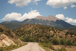
Moab is surrounded by stunning red rock panoramas, sheer cliffs and deep canyons. There are an entire vacation’s worth of sights, hikes and bikes within an hour of the Moab city limits. Getting out of your car to experience our red rock wilderness during the blazing heat of summer can be a daunting proposition, however. Fortunately, there is a cool respite close at hand for those that seek it- The La Sal Loop road, just a few short miles southeast of Moab, climbs high into the mountains. It affords panoramic vistas, forested slopes, cool inviting lakes, small laughing brooks and streams, and temperatures thirty degrees cooler than the sweltering desert below.
 The road is paved and is fine for motorcycles, but riders need to know that there are occasional patches of gravel and should adjust their speed accordingly. The road is paved and is fine for motorcycles, but riders need to know that there are occasional patches of gravel and should adjust their speed accordingly.
The total distance is 62 miles round trip, not counting side trips.
The La Sal mountains are a small range, measuring only 15 miles long and 4 or 5 miles wide. Despite this, they are the second tallest in Utah, with twelve peaks over 12,000 feet (3657 meters) in elevation. They were formed approximately 24 million years ago when stocks of molten rock would find a weak spot and bulge upwards, until the molten rock would encounter a thick sedimentary layer. The lava would then spread until it found another weak seam, and again bulge upwards. This process was repeated many times, but there was so many thick geologic layers that the molten rock never reached the surface. Essentially, the La Sals (and several other ranges in the region, such as the Abajo mountains west of Monticello) are failed volcanoes. They built and built, lifting and deforming the geologic layers above, yet never erupted into a volcano. The lava eventually cooled and solidified. When the ice ages arrived, glaciers scoured away the nearly 5,000 feet of still-remaining geologic formations from the peaks of the La Sals, exposing the igneous cores. The highest elevations of the mountains are composed of shattered and scattered grey rubble composed of this igneous rock.
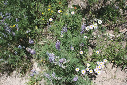
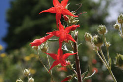 The La Sal mountains are home to black bear, mountain lions, bobcats, coyotes, and dozens of other species. Lower elevations have abundant Juniper and Piñon pine, while higher elevations are crowded with stands of Aspens, Ponderosa pine, Douglas Fir and Engelmann Spruce. The La Sal mountains are home to black bear, mountain lions, bobcats, coyotes, and dozens of other species. Lower elevations have abundant Juniper and Piñon pine, while higher elevations are crowded with stands of Aspens, Ponderosa pine, Douglas Fir and Engelmann Spruce.
Before starting your trip to the mountains, it would be wise to get some water, food and a map, as no services are available after you leave Moab. There are several vault toilets, however.
To access the La Sal Loop road, start at the intersection of Main and Center Streets in downtown Moab and reset your tripmeter, or note your mileage.
Mile 0 Main and Center Streets, Moab. Continue south on Main Street (US Highway 191).
Mile 7.8 Just beyond milepost 118 is Old Airport Road. Turn left here.
Mile 8.3 Old Airport Road ends at a ‘T’ intersection with Spanish Valley Drive. Turn right.
Mile 9.8 RESET YOUR TRIP METER TO 0. You are to continue heading straight at this intersection. For all practical purposes, Spanish Valley Drive becomes the La Sal Loop Road at this intersection.
Ken’s Lake lies .3 miles to the east at this intersection. It offers a refreshing reservoir, hiking, restrooms, a campground, and a beautiful man-made waterfall (“Faux Falls”).
Mile 3.4 The road to the right leads to the Pack Creek campground.
As the road climbs to higher elevations, Piñon and Juniper become more prevalent; as the road climbs even higher the trees get taller.
Mile 10 The road to the right leads to Geyser Pass, nearly 11,000 feet elevation.
Mile 10.2 A vault toilet is on the left.
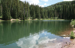 Mile 11.4 The road to Oowah Lake is to the left. Oowah (pronounced Ooh Aah) and Warner Lake are beautiful little lakes surrounded by a dense grove of aspens, firs and spruce trees. The dirt road to Oowah is 3.0 miles one way, and is passable in dry conditions to passenger cars. It can have some sections of mild washboard. Mile 11.4 The road to Oowah Lake is to the left. Oowah (pronounced Ooh Aah) and Warner Lake are beautiful little lakes surrounded by a dense grove of aspens, firs and spruce trees. The dirt road to Oowah is 3.0 miles one way, and is passable in dry conditions to passenger cars. It can have some sections of mild washboard.
There is a toilet at the Oowah Lake campground, elevation 8,800’.
Mile 12.7 This graveled road (approx. 5.5 miles long) travels to the Warner Lake Campground. Warner Lake is similar to Oowah, but with mountain peaks looming nearby. Restrooms are available at this campground. Warner Lake is at 9,200’ elevation.
Mile 15 The road to the Sand Flats Recreation Area (which is also an alternative route back to Moab) is to the left. This highly scenic dirt road will be detailed in a future issue of Moab Happenings.
Over the next several miles, visitors will enjoy the spectacular panorama looking down into Castle Valley.
Mile 19.0 To the left is the road leading to the Pinhook Battlefield. Listed on the National Register of Historic Places, Pinhook Draw was the scene of an 1881 ambush of a posse that had been chasing a mixed band of Utes, Paiutes and Navajos. Eight members of the posse were killed in the clash, and two Moab boys that had been tending cattle in the area were also killed when they wandered over to investigate the sounds of battle. Three more posse members were seriously injured. The number of Indians killed in the battle varies from two to eighteen, depending on the source.
 Mile 23.7 The La Sal Loop Road ends at this intersection. To return to Moab, turn left and follow Castle Valley road to Utah Highway 128. As you drive this road, you will see the famous Castleton Tower (sometimes called Castle Rock) and the Priest and Nuns spires. These famous landmarks have been in many western movies. Mile 23.7 The La Sal Loop Road ends at this intersection. To return to Moab, turn left and follow Castle Valley road to Utah Highway 128. As you drive this road, you will see the famous Castleton Tower (sometimes called Castle Rock) and the Priest and Nuns spires. These famous landmarks have been in many western movies.
There are no services in Castle Valley.
When you reach Utah Highway 128, turn left and follow highway 128 (‘The River Road’) back 15.5 miles alongside the Colorado River to the intersection of US Highway 191. There are many beaches, campgrounds and rest rooms along this stretch of highway. |