Last month’s gully washer, where a rapidly moving thunderstorm dropped nearly 1.5ʺ of rain on the desert, is a good reminder to keep an occasional eye on the sky. That, and don’t camp in dry desert washes.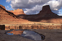
During July, the standard weather forecast calls for “a chance of afternoon thunderstorms.” When I worked as an NPS seasonal in the 1980s, some visitors would scoff at this prediction especially on those cloudless mornings. I’d explain about the Canyon Country monsoon season and how the thunderheads would build during the day and to beware of high places for lightning and canyon bottoms for floods. Many of the afternoon storms would be short-lived or confined to the mountains or sweep across a particular portion of the region while, quite literally, a few feet away the soil would be dry.
Desert landscapes are often enhanced by the skyscapes. Parades of clouds give depth and background to the area’s unique geologic features. Watching a distant lightning storm igniting the sky from a high vantage point is an amazing sight, but one that needs a caution asterisk: “Do not stand here during electrical storms.”
Over 200 years ago, a self-proclaimed day dreamer spent his days watching clouds and weather patterns from his London residence. Luke Howard (1772-1864), a pharmacist and budding amateur meteorologist in 1802, observed and noted the various cloud formations over the city but he lacked a vocabulary for various categories of clouds. So, he devised a naming system that still exists, in part, today.
Utilizing Latin which was the language used to scientifically describe plants and animals, Howard started with three basic forms: cirrus (meaning “curl”), cumulus (meaning “heap or pile”), and stratus (meaning “layer or sheet”). Howard added more nomenclature to his system for those transitional types of clouds which resulted from these three basic forms. His On the Modifications of Clouds published in 1803 gave form to this classification system and his eventually nickname: “The Namer of Clouds.”
 Prior to 1800, little thought was given to clouds due to their ephemeral nature. Utilizing the nomenclatural classification that Carl von Linne (Linnaeus, 1707-1778), a Swedish botanist and zoologist, devised in the mid 1700s for plants and animals, Howard applied this hierarchy to cloud identification. Altitude also played a role in this classification, separating clouds in High, Middle, and Low categories. Today, there are 10 genera of clouds.
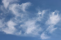
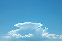
A couple of these genera are Cirrus clouds which are the high-altitude wispy clouds (forming between 16,000 and 50,000 feet) often called “Mare’s tails” after their resemblance to a horse’s tail flicking back and forth. This type of cloud generally indicates an upcoming change of weather. Another group are Cumulonimbus, better known as “Thunderheads”, which may form at low altitudes but gain impressive elevation. The term cumulonimbus translates to “heap” and “rain” after their puffy size and potential for precipitation. These awe-inspiring thunderheads demand your respect.
Though thunderstorms may be spectacular to watch, remember to seek out a safe, grounded spot to do so and beware of what may follow – flashfloods racing down canyons or pouring down cliff walls. After all, you’ll want to see what clouds tomorrow may bring.