Hiking Distance: Wander at your leisure
Cautions: High temperatures in summer, remote location
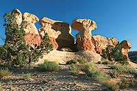
The Devils Garden in the Grand Staircase-Escalante National Monument (not to be confused with the Devils Garden in Arches National Park) only encompasses a small area of the monument’s 1.9 million acres, but it includes some of the most iconic formations in all of canyon country. Here, erosion has transformed the Entrada Sandstone into an enchanted playground of spires, arches, and hoodoos. 
About 175 million years ago—about the same time that large dinosaurs were roaming the area—the Entrada Sandstone was a large desert of fine-grained sand dunes. As these wind-blown dunes accumulated and solidified over millions of years, some layers were harder and more resistant to erosion and weathering. Gradually, the erosional forces of wind and water wore away the softer layers of rock, leaving behind the harder remnants that morphed into the spires and goblin-like structures in the Devils Garden.
As you travel through the Grand Staircase-Escalante National Monument via the scenic Utah Byway 12, take a moment to ponder the fact that you’re in the last territory to be mapped in the lower 48 states. The first person to accomplish this daunting task was a man named Almon Harris Thompson. Thompson had family ties to the adventurous life—his brother-in-law was John Wesley Powell, whose exploration trips down the Colorado River are now legendary. In the early 1870s, Thompson joined Powell on a three-year expedition to explore the Colorado and Green Rivers and map southern Utah and northern Arizona.
Getting to the Devils Garden requires driving about 12 miles down the Hole-in-the-Rock Road, a dirt and gravel road that eventually ends up 57 miles away at Lake Powell. From the small parking area, you can wander among the otherworldly rock structures as you wish, and there isn’t much of a trail to speak of. Kids and adults alike can amuse themselves for hours playing hide and seek and exploring the sandstone nooks and crannies. 
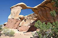
No matter which direction you head in first through the maze of rock spires, you’ll eventually stumble upon Metate Arch, the landmark feature of the Devils Garden. Named for the stone tool used by Ancestral Puebloans to grind corn, Metate Arch is a uniquely shaped caprock arch, created when adjacent layers of rock eroded at different rates. Not far from Metate is its companion, Mano Arch (a mano is the round stone used to grind corn inside the metate).
Late in the day when the sun dips to a low angle, the formations in the Devils Garden take on a red glow. Plan to visit just before sunset, and you’re likely to capture some truly spectacular photos.
The Escalante Slot Canyons
The Escalante area is known for its intricate maze of slot canyons that beckon canyoneers from all over the world. Slot canyons are much deeper than they are wide, with some sections that are so narrow you’ll barely be able to squeeze your body through (if you’re at all claustrophobic, don’t even think about it). If you’re up for a true adventure, however, taking a trip through a slot canyon will be an experience you won’t forget. Just be sure to go with an experienced guide.
Several professional outfitters operate out of the Escalante area. These guides are extremely knowledgeable about the local terrain and can help you select a destination that’s appropriate for your fitness and skill level. Trips range from day hikes that take you into shorter slot canyons, to technical canyoneering trips that involve rappelling into deep canyons using ropes. Overnight trips that take you deeper into the Escalante Canyons can also be booked.
Getting There
The Devils Garden is roughly 225 miles from Moab, so you can make it an overnight trip, or you can combine it with a trip to other Utah national parks and monuments. The drive from Moab takes you through two spectacular areas: Capitol Reef National Park and Utah’s Scenic Byway 12, rated as one of the most beautiful highways in the world.
From Escalante: Head east on Utah Scenic Byway 12 for 5 miles. Turn right onto Hole-in-the-Rock Road and drive for about 12 miles to the signed turnoff for Devils Garden. Turn right and follow the short dirt road to the parking area. Hole-in-the-Rock Road is unpaved, but most two-wheel drive vehicles won’t have any problem getting as far as Devils Garden. The road is often wash-boarded, so be prepared for dust and a few bumps. It’s always a good idea to check on road conditions before heading out. |