|
|
Must-See HAPPENINGS June 2017
|
The Legends of Dead Horse Point
by Laurie Schmidt |
Hiking Distance: Minimal to overlook
Cautions: High temperatures during summer; steep
drop-offs
Let’s face it, a name like Dead Horse Point doesn’t exactly conjure up visions of sugar plum fairies and Norman Rockwell scenes. But you can tell the animal lovers in your group not to worry—you won’t see any dead horses lying around. What you will find is one of Utah’s most inspiring views from about 2,000 feet above the Colorado River. 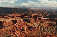
It’s often said that the view from Dead Horse Point rivals that of the Grand Canyon. Although the Grand Canyon is a geologic panorama on a much larger scale, the same erosional forces created the vista you see from Dead Horse Point. The rock strata visible from the overlook are the result of more than 300 million years of erosional history, from the Pennsylvanian to the Jurassic Period.
The most prominent feature to the southwest is the Gooseneck of the Colorado, where the river snakes its way around a tight bend. Here, the river flows for about four miles while only advancing a quarter mile in actual distance.
Where are the Dead Horses?
People have been asking about the park’s name ever since it opened in 1959. To help you understand the folk tale that’s been told for years, it’s important to know that reaching the main overlook requires crossing a narrow stretch of land called the “Neck,” which is only about 30 feet wide with steep cliffs on both sides.
According to the most common legend, back in the 1800s cowboys came to the area to catch wild horses. They would corral the horses out onto the point and then build a natural fence out of brush and branches across the Neck to trap them. After choosing the horses they wanted, they would leave the others to die of thirst on the point—in direct view of the river’s water below. Mean cowboys.
But this theory sounded too cruel to be true to Jordan Perez, who used to be an interpretive ranger at Dead Horse Point State Park. “I couldn’t stand the look on people’s faces when I would tell them this story,” he said. So, in 2012 he set out on a mission to find out the true origin of the park’s name.
While researching old newspaper articles and museum archives, he came across a book called Grand Memories, which included an essay written by Lydia Taylor Skewes, the daughter of a well-known pioneer and rancher named Arthur Taylor. According to his daughter’s account, during the late 1800s Arthur and his sons ran cattle on the mesa near the present-day park. The cows would get their drinking water from sandstone potholes, which filled with water after heavy rains. Some of these potholes were fairly deep—large enough for a human to fall into and have difficulty getting out. 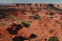
The water level in potholes always varies seasonally, but as the region experienced a period of drought, the potholes started drying up completely. During this drought period, Arthur and his sons brought their cattle back to the mesa one fall and found dead horses in the potholes. Desperate for a drink of water, the horses had fallen in the deep potholes and then starved to death when they couldn’t get out. From that point on, Arthur Taylor called the area Dead Horse Point.
Perez became convinced this was the true origin of the park’s name. During his research, he found an article published in 1965 in Moab’s newspaper, the Times Independent, which confirmed the story through interviews with local families. So, you can assure your kids that there were no mean cowboys—well, at least not ones that left horses to die of thirst.
An interesting side note: Thelma and Louise took their famous final plunge from a plateau off the Shafer Trail, the dirt road that’s visible from the Dead Horse Point overlook. The location served as a “stunt double” for the Grand Canyon in the movie.
Getting There
From Moab: Head north on Highway 191 for 9 miles. Turn left on State Road 313 and drive 23 miles to the park. After about 15 miles, be sure to make the left turn to continue on SR 313. Dead Horse Point is at the end of SR 313. |
Laurie Schmidt is the author of Utah Canyon Country: 20 Must-See Sites and Short Hikes. This article is excerpted from the book. Learn more about her book at www.utahcanyonhikes.com.
|
|
Tips For Summer Fun at Dead Horse Point in Moab
by Saige Culbertson |
Summer time in Dead Horse Point State Park in Moab, Utah is meant for fun hikes, bike rides, and exploring the environment. Dead Horse Point State Park is only 9 miles Northwest of Moab and has awesome bike trails, delightful hikes, and beautiful views of the Colorado River. While visitors to our state park come to see the stunning views, it is crucial to keep in mind Summer safety tips for themselves and fellow visitors. 
Our first tip for our lovely visitors is staying hydrated in the summer heat. Hydration may be a no brainer for some, but up to 50 people die a year from heat related illnesses. Summers in Moab can reach up to 100 degrees Fahrenheit or higher. Due to Dead Horse Point being just under 6,000 feet of elevation and it can be up to 8 degrees Fahrenheit cooler than in the town of Moab, it is important to always bring a gallon of water or more for yourself, and half a gallon for your pet. Heat exhaustion can be sneaky, so if you’re feeling too tired, hot, have a headache, or your mouth is feeling dry, we recommend you take a break from your fun activities and drink water. Plants such as sagebrush, juniper, and Pinyon Pine trees can provide little to no shade. However, air condition is provided in our visitor center. Whether you’re planning on hiking, cycling, or just going for a drive through the park you should keep drinking water throughout the day to avoid dehydration. You are welcome to bring small nutritious snacks, or buy some in our visitor center to combat any symptoms of heat exhaustion as long as wrappers end up in the trash cans provided throughout the park. To accommodate visitors, we also have a drinking fountain in our visitor center two miles South of our entrance gate for a refill!
Wearing sun protection will not only protect your body but can make the summer heat a bit more bearable. Hats, sunscreen, sunglasses are examples of sun protection to keep you safe. It is important to reapply sunscreen at least every 80 minutes 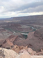 to maintain maximum protection. Peak times for sun exposure are between 10 a.m. and 2 p.m., however continue to apply sunscreen before and after those times during your visit. Make sure to check your skin for any redness to avoid sunburn and sun damage. Hats and longer clothing will help block out some of the UV rays. Reapplication and generous amounts of sunscreen are important to keep in mind for sun safety.
Lastly, car safety and safe driving in the area is of the utmost importance. While it may be more convenient to just turn off the car and run inside for a moment while leaving your child or pet inside, it is extremely dangerous. A car can reach between 30-70 degrees Fahrenheit hotter inside the car compared to the temperature outside. The drive on US 191 and Utah 313 has remarkable views of the Mesas and the La Sal mountains, but the winding roads can be dangerous. Make sure you are paying attention to any road signs along the routes and try not to drive higher than the speed limit. You are encouraged to view our wildlife, but we ask that you do not interact with them or their home while in or around Dead Horse Point State Park. Please stay on the roads, trails, and designated areas on your visit in order to keep our state park looking beautiful and to keep yourself safe. Thank you for your support and stop on by for a visit!
|
. |
|
|
|
|
|
© 2002-2024 Moab Happenings. All rights
reserved.
Reproduction of information contained in this site is
expressly prohibited.
|
|