Hiking Distance: Short paved path from parking area
Cautions: Remote location, access via 10 miles of unpaved road
If your trip through Utah canyon country will include a visit to the Bryce Canyon area, you’ll pass through sections of the Grand Staircase-Escalante National Monument (GSENM). Encompassing about 5,000 square miles, the GSENM is one of the best locations in the world to get an up-close look at erosion-carved features such as arches, natural bridges, and slot canyons.
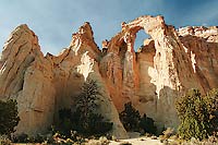
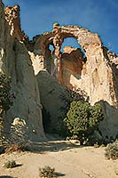 Standing like a grand sandstone cathedral in the middle of the desert, Grosvenor Arch is one of the highlights of the GSENM. At 152 feet high, Grosvenor is a prime example of a geologically rare double arch—a pair of arches that share the same rock base on one side. The arch is cut from three different rock formations: the pale-colored rock at the bottom is the Henrieville Sandstone, which is lighter than many other types of sandstone because it has lower iron content. Above that sits a darker boundary layer of the Cedar Mountain Formation, and the very top is capped with the sedimentary rock of the Dakota Formation. Standing like a grand sandstone cathedral in the middle of the desert, Grosvenor Arch is one of the highlights of the GSENM. At 152 feet high, Grosvenor is a prime example of a geologically rare double arch—a pair of arches that share the same rock base on one side. The arch is cut from three different rock formations: the pale-colored rock at the bottom is the Henrieville Sandstone, which is lighter than many other types of sandstone because it has lower iron content. Above that sits a darker boundary layer of the Cedar Mountain Formation, and the very top is capped with the sedimentary rock of the Dakota Formation.
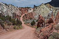
To get to this spectacular arch, you’ll have to leave the safety net of pavement for about 10 miles, but the payoff is well worth the effort. Depending on weather and when the road was last graded, the drive can be a bit of a bumpy washboard, but if you drive slowly, the route is typically suitable for most vehicles. Be aware that there is one wash crossing that can become difficult or impassable after wet weather. Don’t attempt it if it looks questionable, especially if you’re in a regular passenger car. There are also a couple of rocky sections that require cautious driving.
From the parking area, it’s an easy walk to the arch. Be sure to explore the arch from various angles, all of which give completely different perspectives. The best time for photographs is typically late afternoon, when the sun casts a golden glow on the arch.
What’s up with the Hard-to-Pronounce Name?
After your first look at this majestic arch, you might find yourself thinking that they could have come up with a more creative name…something like Cathedral Arch or Temple Arch, or even Knock-Your-Socks-Off Arch. But, alas, like many landforms in the West, the arch now has a person’s name attached to it—that of Gilbert Grosvenor, the founder of the National Geographic Society.
Grosvenor didn’t name the arch himself, though. In 1949, writer and photographer Jack Breed was part of the first motorized expedition into the Escalante region. One day, the party stopped on a high plateau and climbed to the top of a mesa with a commanding view of the area. When Breed looked through his binoculars and spotted an opening in one of the distant sandstone fins, the group set out to investigate. “What we saw was an arch—a new arch, uncharted and unnamed,” said Breed in an article he later wrote for National Geographic.
The uncharted part was probably true, but like many features in the Colorado Plateau region, the arch was likely known by local ranchers and farmers long before the expedition party stumbled on it. In fact, records show that the arch was once known as Butler Arch. Nonetheless, Breed named the arch in honor of Gilbert Grosvenor because he believed that Grosvenor “had done more than any other person to arouse public interest in geography.”
 Cottonwood Canyon Road Cottonwood Canyon Road
After visiting Grosvenor Arch, you can continue south on the unpaved Cottonwood Canyon Road for another 35 miles, where you’ll eventually connect with US 89 in northern Arizona. The Cottonwood Canyon Road parallels the Cockscomb, a wall of steeply inclined layers of rocks that make up part of the East Kaibab Monocline. The entire 46 miles can usually be driven in a two-wheel drive car, but recent storms can make the road impassable even to 4WD vehicles. Don’t take chances; check current road and weather conditions before you head out on this adventure.
Getting There
From Cannonville, Utah (15 miles from Bryce Canyon National Park): Head south on Main Street/Kodachrome Road, which becomes Cottonwood Canyon Road. About 7 miles from Cannonville, the pavement will end. Continue straight on the gravel road for about 10 miles to a short spur road that leads to Grosvenor Arch. A sign marks the turnoff to the arch.
|