Hiking Distance: Short easy walk from parking area
Cautions: Steep drop-offs
Goosenecks State Park may not be the first place that comes to mind when you think of Utah canyon country, but it is without a doubt one of the most impressive viewpoints in the American Southwest. Just a few steps from your car, you’ll gaze down upon a scene that makes geologists downright giddy.
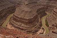
About 1,000 feet below the rim, the San Juan River has carved a deep canyon that snakes around three tight turns called the “goosenecks.” This section of the river has so many hairpin loops that it flows for six miles while only advancing about a mile and a half in actual distance.
Millions of years ago, the San Juan River flowed on a fairly flat plain. During a period of geological uplift the landscape rose, causing the river to cut into the land and carve the meanders that are visible today from the Goosenecks overlook. The gray-colored rock and ledges near the top of the rim are the shale and limestone that make up the Honaker Trail Formation, which was deposited in shallow seas about 300 million years ago and is known for being rich in fossils. Many geologists consider the Goosenecks of the San Juan to be one of the best examples of an entrenched meander in the world.
 The Pioneer of Whitewater Tourism The Pioneer of Whitewater Tourism
The San Juan River begins its journey in southwestern Colorado near the town of Pagosa Springs, where it then flows 360 miles to its confluence with the Colorado River. John Wesley Powell’s famous expedition down the Colorado River first explored the mouth of the San Juan River in July 1869. Some 60 years after Powell’s legendary journey, the San Juan River would become an adventure vacation destination, thanks to a young man named Norman (Norm) Nevills.
In the late 1920s, Norm Nevills settled in Mexican Hat when he and his mother moved there to join his father who was working in southeast Utah’s booming oil industry. Norm helped his father develop a promising oil well, and the two also built the Nevills Mexican Hat Lodge, which opened to travelers in 1933. That same year, the Rainbow Bridge-Monument Valley expedition arrived in Mexican Hat to embark on a trip down the San Juan River through Glen Canyon and on to Lee’s Ferry. After Norm helped members of the expedition launch their trip on the San Juan, he began hatching a plan to build his own boat—the river bug had bitten him.
Norm’s river skills were honed in 1936, when he was asked to guide an expedition down the San Juan and the Colorado to Rainbow Bridge. Then in 1937, a botanist from the University of Michigan named Elzada Clover stayed at the Nevills Lodge while studying plants in the area. Clover was interested in collecting and investigating native plants in the Grand Canyon, and Norm convinced her that the best way to do that was on a boat.
The next year, Norm guided Clover and two of her graduate students through the Grand Canyon. The trip became a media sensation, proclaiming Clover and one of her students the “first women through the Grand Canyon.” The resulting publicity brought fame for Norm and his river-running skills, and “Nevills Expeditions” was born. Norm continued to guide passengers down the San Juan, Colorado, and other western rivers until his untimely death in 1949, when he and his wife Doris were tragically killed in a plane crash in Mexican Hat.
If you’re keen to experience the Goosenecks from the bottom looking up, several companies offer guided trips on the San Juan, including day trips that float the 26 miles between Bluff and Mexican Hat and multi-day trips covering up to 84 miles. The San Juan River makes an excellent family trip, offering enough small rapids to add some excitement without making the more skittish family members wish they’d stayed at home.
Getting There
From Moab: Follow Hwy 191 south through Monticello, Blanding, and Bluff (100 miles). Past the town of Bluff, take Hwy 191/Hwy 163 for 21 miles and turn right onto SR 261. After about 1 mile, turn left on SR 316 and drive 3.5 miles to the parking area. There is a $5 self-pay entrance fee per vehicle. |