Hiking distance (round-trip): 4 miles
Difficulty: Easy
Cautions: Potentially dangerous river crossings during high spring runoff
At 130 feet high, the massive Escalante Natural Bridge is dramatic in its own right, but half the fun of seeing this site is getting there. The 2-mile trail (one way) involves fording the Escalante River five times, and you’ll really appreciate these crossings during the hot summer months. Water shoes or sandals will serve you well on this trail.
Next to the trail register, a path leads from the parking area to the river, where you’ll need to ford the stream. The bottom can be rocky and slippery on this first crossing, so a hiking stick is a good idea. The other crossings are easier, with a mostly sandy bottom.
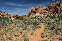
The trail to the bridge is mostly sand with very little elevation gain. Although there are some side trails that occasionally branch off the main path, it’s fairly easy to recognize the main trail. Once you reach the natural bridge, there is more opportunity for wading, splashing, and cooling off in the Escalante River’s clear waters. Find a comfy spot in the sand, and it’s the perfect spot to have lunch while gazing up at the bridge and the spectacular Upper Escalante River Canyon.
 The Escalante Canyons The Escalante Canyons
As a major tributary of the Colorado River, the Escalante is one of two arteries that flow through the Grand Staircase-Escalante National Monument (the other one being the Paria River). It was the last river to be identified within the contiguous United States and was first mapped in 1872 by Almon Thompson, a cartographer who was a member of John Wesley Powell’s famous expedition down the Colorado River. Thompson named the river after Silvestre Vélez de Escalante, a Franciscan priest who, along with Francisco Atanasio Domínguez, explored the area in 1776 looking for an overland route from Santa Fe to California.
As it makes its way to Lake Powell, the Escalante cuts through the lower Morrison, Dakota, and Entrada Sandstone Formations, which were deposited as the region fluctuated between marine, lake, and desert environments. Along this sinuous journey, the river has spawned a maze of steep, narrow canyons—a utopia for hikers and canyoneers. In fact, Utah has the highest density of slot canyons in the world, and many of these are side canyons of the Escalante River. (Slot canyons can be as dangerous as they are fascinating; if you decide to explore one, be sure and check weather conditions or go with a professional guide.)
Does a River Run through It?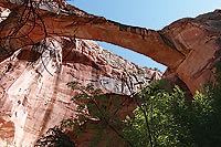
Despite its name, Escalante Natural Bridge is officially classified as an arch. To qualify as a natural bridge, an arch opening must span a water source, such as a river or stream. By contrast, an arch has no connection to running water but was instead created through the processes of wind, sand, and water erosion (not flowing water, but seeping water and freeze/thaw cycles).
Sometimes the water source under a natural bridge dries up or changes its path, but it’s still considered a natural bridge because of the way it originally formed. Or, an arch may have a water source flowing near it that makes it seem like a natural bridge when it’s really an arch. So, even though Escalante Natural Bridge is next to the Escalante River, it was not formed by the river’s flowing water. Presumably, the bridge got its name because of its proximity to the Escalante River, or somebody named it many years ago and the name stuck.
If you’re not confused yet, hold on. Continue hiking about a half mile beyond Escalante Natural Bridge and you’ll come to Escalante Natural Arch (sometimes called Skyline Arch). Look up high on the south (left) side of the river and you’ll see a narrow, long arch opening. The arch is also visible from the trail to the natural bridge, look up to the right just after the fourth stream crossing.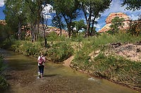
Getting There
The Escalante River Trail is roughly 200 miles from Moab, so you can make it an overnight trip, or you can combine it with a trip to other Utah national parks and monuments. The drive from Moab takes you through two spectacular areas: Capitol Reef National Park and Utah’s Scenic Byway 12, rated as one of the most beautiful highways in the world.
From Moab: Head north from Moab on Hwy 191 for 31 miles to I-70. Turn left to merge onto I-70 west and continue for 33 miles to Exit 149 for UT-24. Turn left from the exit ramp, and drive for 44 miles to Hanksville. Turn right to stay on UT-24 west, and continue 47 miles to UT-12. Turn left (south) onto UT-12 and continue for 50 miles. Just before crossing the bridge over the Escalante River, turn right into a small parking area.
|