Travelers on their way to Moab or Monument Valley usually blast right past the sign on Hwy 191 marking the turnoff to Hovenweep National Monument. And even if they do notice the sign, they’re not quite sure if it’s something they should drive 30 miles out of their way to get to. Trust me when I say that it’s worth the detour. 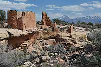
About 1,000 years ago, southeast Utah was home to ancient Pueblo peoples, known as Ancestral Puebloans (or Anasazi), who built cliff dwellings and towers throughout the Four Corners area. Although the southwest U.S. is teeming with the ruins and rock art of these ancient people, most of the sites are in remote locations, and getting to them requires advanced hiking and route-finding skills. At Hovenweep, however, an easy two-mile loop trail takes you through a cluster of ancient towers and structures considered by many to be some of the finest ancient architecture in the Southwest. In short, it’s a huge payoff for relatively little effort.
The Square Tower group, Hovenweep’s largest collection of ruins, sits on a 500-square-mile elevated tableland called Cajon Mesa. The mesa is drained by a series of intermittent streams that eventually flow into the San Juan River, and it was the water from these streams and numerous springs that likely led people to settle and construct dwellings here.
 Tree-ring dating has determined that most of the structures in the Square Tower group were built between A.D. 1230 and 1275, and archaeologists estimate that about 100 people were living here in 1270. But by 1300, the Ancestral Puebloans had abandoned not just Hovenweep, but the entire Four Corners region. Tree-ring dating has determined that most of the structures in the Square Tower group were built between A.D. 1230 and 1275, and archaeologists estimate that about 100 people were living here in 1270. But by 1300, the Ancestral Puebloans had abandoned not just Hovenweep, but the entire Four Corners region.
Researchers and archaeologists have puzzled for years over the question of why they left. One theory holds that climate change and drought struck the region in the 13th century, making survival there impossible and forcing the Puebloans to head to more fertile lands. Indeed, tree-ring data show that a severe drought began around 1276, about the same time that construction at Hovenweep stopped. Scarcity of resources may have also triggered social unrest and violence.
Despite the intrigue of imagining a “lost civilization,” the truth is that the Anasazi-Pueblo culture is still alive, and its descendants now live in the same place where their migrations eventually took them—present-day Arizona and New Mexico.
Little Ruin Canyon Trail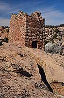
The trail around Square Tower’s Little Ruin Canyon begins just outside the visitor center and loops around the rim for 1.5 miles before dropping into the canyon and climbing back up the other side. A half-mile spur trail to Tower Point increases the total walking distance to 2 miles.
As you make your way down the short paved path to the canyon rim, Stronghold House comes into view. The structure you see here today is actually the top story of a larger pueblo, the remains of which are visible on the slope below. It’s believed that people entered Stronghold House via wooden ladders or steps chiseled into the rock.
Heading east along the rim, you’ll soon reach a spur trail that takes you to Tower Point at the end of a “peninsula” that splits the canyon into two sections. Here, you’ll get outstanding views up and down Little Ruin Canyon. At the end of the loop, you’re rewarded with a view of the “grand cathedral” of Hovenweep: Hovenweep Castle. This structure consists of a D-shaped tower and attached room blocks perched precariously on the edge of the canyon rim. Archeoastronomers have proposed that portholes in one of the Castle’s rooms are situated to mark the winter and summer solstices, which could have been used to estimate growing seasons and planting dates.
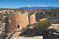
Adjacent to Hovenweep Castle on the canyon floor is the two-story Square Tower. In the dry desert Southwest, trees are always a dead giveaway to the location of water sources, so pay attention to the hackberry trees near the tower—they’re evidence of the seep under the alcove that gave Square Tower residents a valuable supply of water.
The next structure is Hovenweep House, which was once much larger but has now crumbled. This vantage point offers excellent views of Hovenweep Castle across the canyon. You’ll have a brief walk along the rim before coming to the next ruin, so it’s a good time for a rest break while you take in the distant views of all the towers and ruins that line the canyon.
After passing Rimrock House, a two-story rectangular structure that may have served as an observatory or lookout tower, you’ll reach the second largest structure in the Square Tower group—Twin Towers. According to archeologists, these towers display some of the most advanced masonry skills of any ancient dwelling in the Southwest.
A short distance beyond Twin Towers, you’ll descend about 80 feet to cross the canyon and return to your starting point on the other side. You can also turn around and backtrack the way you came, which will give you a different perspective on the structures.
Hiking Distance: 2-mile loop
Difficulty: Easy
Cautions: Remote location with no services
Getting There
From Moab: Drive south on Hwy 191 for 90 miles. Turn left on Utah 262 and follow the signs to Hovenweep National Monument. It’s about 30 miles to the Hovenweep visitor center.
*Note that using GPS to get to the park is not recommended. The park has several outlying units that are accessible via a network of dirt roads, and GPS is notorious for sending visitors to unknown locations.*
|