.jpg) The Cameo South is 25 miles south of Moab and it is an area never before visited by Jeep Safari. Jack Bickers, a club member in the beginning years, contributed many things to the EJS, mostly related to our trails and their names. Jax Trax is a tribute to Jack, made up of old mineral exploration roads he rediscovered in the 1990s. The trip has been carefully chosen to provide some four wheeling challenges while maximizing the views of the abundant scenery in this area. Those looking for extreme challenges will be disappointed, but novices are advised they may want to choose a different trip also. Approximate mileages: 80 overall, 16 off pavement. The Cameo South is 25 miles south of Moab and it is an area never before visited by Jeep Safari. Jack Bickers, a club member in the beginning years, contributed many things to the EJS, mostly related to our trails and their names. Jax Trax is a tribute to Jack, made up of old mineral exploration roads he rediscovered in the 1990s. The trip has been carefully chosen to provide some four wheeling challenges while maximizing the views of the abundant scenery in this area. Those looking for extreme challenges will be disappointed, but novices are advised they may want to choose a different trip also. Approximate mileages: 80 overall, 16 off pavement.
Scenery
Bordered on the north by Wilson Arch, the south by Steen Road, on the east by Lisbon Valley, and on the west by US191, there is abundant scenery on this trip. Cameo Mesa, Agate Point, Mikie’s Knob, and Casa Colorado Rock are some notable features, while the LaSal Mountains tower over the area, and the Abajo Mountains are very visible in the distance.
Surface
There are some sandy wash bottoms, some two track dirt sections, a lot of climbs and descents on slickrock, and a shelfy hill or two.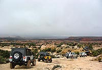
Trail Details
The rating number gives the hint there won’t be many obstacles worthy of names, but Jack did leave us with the “Top Notch” and “El Diablo” monikers. The latter, while not technically difficult for most vehicles, can be intimidating to the driver. Don’t worry, there is an easier bypass. Many obstacles consist of small ledges as different rock layers are crossed, some sandy sections through sagebrush can be soft, and there are a few rubble strewn hills.
 TRAIL NOTES TRAIL NOTES
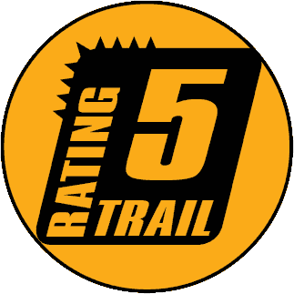
Length: 80 overall, 16 off pavement
Min Tire Size: 33+ inches
Winch: No
Front Locker: No
Rear Locker: Yes
|
Trail Difficulty Ratings are for Moab area roads in dry conditions. The effects of snow or rain varies greatly depending upon the altitude of the roads and the type of soil.
NOTE: The Red Rock 4 Wheelers Club attempts to keep the trail ratings current. However weather and usage constantly alters the routes. Heavy but localized rains can change Kane Creek from a moderate trail to impassable in an afternoon. It is always wise to obtain the most up-to-date information prior to departing for a trip, and be prepared. Remember, turning back is usually an option as well.
For more information see the Red Rock 4-Wheeler website, www.rr4w.com, where the entire Easter Jeep Safari magazine is online. |
|
 Trail surfaces are rutted, rocky and sandy with steps not exceeding 24”, with considerable slickrock surfaces. Water not exceeding 12” with some mud possible. Good ground clearance and driving skills are needed. 4WD, tall tires (33” plus) (35” would be a plus, but not required) and working traction adding devices (locker, limited slip) are required. Above average driving skills are desirable. A winch would be a plus. Enhanced suspension travel and good ground clearance are also required. |
|
 Each year we lose a few more roads/trails. Closed to us forever! It’s a horrible thought, but reality! Take a minute and think about what it would mean to you to have your favorite trail closed. One of the best ways to fight this is to practice responsible Each year we lose a few more roads/trails. Closed to us forever! It’s a horrible thought, but reality! Take a minute and think about what it would mean to you to have your favorite trail closed. One of the best ways to fight this is to practice responsible
4-wheeling.
Stay on the trail. Don’t be tempted to try a new route or obstacle. Someone will follow your tracks and soon we’ll have another unauthorized road. Go over the bumps and mud, not around them. That’s what 4-wheeling is all about.
Pack out what you pack in. If you see litter on the trail, pick it up and take it out with you. Most of all, take care of and respect this land that we love to play on.
Responsible 4-Wheeling will make a difference. Please join with the Red Rock 4-Wheelers and practice responsible
4-wheeling every day. Let’s show them that we care.
|