|
|
HIKING HAPPENINGS May 2011
Lathrop Trail - A Very Long Walk To The River
article and photos by Marcy Hafner
Island In The Sky, with an average elevation of 6100 feet, is the highest district within Canyonlands National Park. Situated like a desert island, this sheer-walled plateau is surrounded by a far-reaching, isolated landscape that drops 2,000 feet to the surging waters of the Colorado and Green Rivers. On a clear day, a person can see for almost 100 miles across a tangled web of canyons, mesas, buttes, fins and spires - a wondrous horizon-to-horizon view climaxed by three distinct mountain ranges - the La Sals to the east, the Abajos to the south and the Henry Mountains to the west.
 Before it was awarded park status, few except Native Americans, cowboys, river explorers and uranium prospectors entered this rugged, remote corner of southeast Utah. Even today, the majority of the park, which covers 527 square miles, is an untamed wilderness where coyote, deer, kit fox and desert bighorn sheep have enough undisturbed space to freely roam. This protected habitat is particularly important for the desert bighorns, whose population has plummeted dramatically since modern man arrived. Before it was awarded park status, few except Native Americans, cowboys, river explorers and uranium prospectors entered this rugged, remote corner of southeast Utah. Even today, the majority of the park, which covers 527 square miles, is an untamed wilderness where coyote, deer, kit fox and desert bighorn sheep have enough undisturbed space to freely roam. This protected habitat is particularly important for the desert bighorns, whose population has plummeted dramatically since modern man arrived.
In the late 1950s and early 60s, Bates Wilson, then superintendent of Arches National Monument, led groups of scientists and government officials into the canyonlands. When they sat around the campfire in the evening the talk inevitably turned to the possibility of designating this amazing area as a national park.
United States Senator Frank E. Moss, who represented Utah, introduced park legislation, saying “I will never lose sight of the fact that the most important thing for Utah and the United States is to set aside (and) preserve this beautiful area as a great national park in the tradition of Yellowstone, Grand Canyon and Yosemite.” And so the spark of an idea became a reality in 1964.
I am embarking on the Lathrop Trail – the only marked route that goes from Island In The Sky all the way to the Colorado River – a grueling18 mile round trip hard-core hike. But to observe those tremendous canyonland views, I only have to hike 2.5 easy-going miles to the rim above upper Lathrop Canyon.
To get there, drive ten miles north of Moab on Highway 191. At Highway 313, turn left and drive another 25 miles to the park’s entrance station where the trailhead is two miles after the visitors center.
Howard Lathrop, a sheep rancher from Colorado, constructed this trail in the 1940s so he could transport his supplies to the White Rim, where his free ranging sheep grazed. Sheep ranchers and uranium prospectors regularly traveled this back road until Canyonlands became a national park.
Located 1200 feet below the Island in the Sky mesa, the White Rim is the top of the Cutler Formation, a wide bench of sandstone that was deposited 225 million years ago. In the 1950s uranium prospectors constructed a road on this rim to access the uranium deposits in the area - a short-lived mining boom that came to a halt by the end of the decade. The miners also built a road to the river - a continuation of the Lathrop Trail - to obtain water for their mining operations. Since that era, the White Rim Trail, which is almost 100 miles long, has grown in popularity with mountain bikers and jeepers.
The first 1.6 miles of rolling grassland, known as Gray’s Pasture, provides stunning views of the entire range of the snow-covered La Sal Mountains. On this sandy trail, which travels through a prairie of thick wind-tossed grass, I am constantly noticing the abundance of Mormon Tea, as the slender upright, bright green branches on this odd-looking shrub appear leafless. The whorls of scales at the joints, however, are actually considered leaves – an 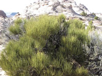 intriguing strategy that reduces evaporation. intriguing strategy that reduces evaporation.
In this wide-open country, I am pleased to see that black-throated sparrows have returned from their winter vacation in Mexico, as these denizens of the desert are early harbingers of spring. In this land of meager precipitation (less than ten inches a year), only the well adapted survive, and these hardy birds are masters at desert survival - they can usually extract all the moisture they need from their diet of seeds and insects.
Towards the end of Gray’s Pasture, I spy a tin shack 150 yards off to the left of the trail. The supplies, which the sheepherders carted in on a wagon, were stored in this shed until they could be packed down to the White Rim.
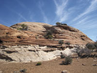
Soon after that structure, the sloping, sandy trail now switches to long stretches of slickrock that wanders past potholes and several impressive domes. I particularly like the pocketed shelters within the slickrock walls that have created a refreshing pinyon pine, juniper tree and cliffrose Garden Of Eden.
I steadily drop down one small bench after another until the trail eventually slips through a small break in the Navajo Sandstone wall and deposits me on a narrow ledge. Now a steep rock wall towers up on the right, while the exposure of a 600 foot cliff of Wingate Sandstone plummets below where I am standing!
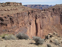
I gingerly walk to the upper end of Lathrop Canyon, where the steep switchbacks start their rugged drop down – one look is all it takes to convince me this is as far as I need to go!! Fifty years ago, the descent from here to the White Rim must have been a tremendous challenge for packhorses! The switchbacks would be the hardest part – after that, the rest of the way to the river is much easier.
From this observation point, I am looking down on Airport Tower, the White Rim Trail and the wide swinging, goose-necked meander of the Colorado. Across the river, I can pick out the sharp pointed features of The Needles district of Canyonlands National Park, and beyond that, the Abajo Mountains.
As I settle down to let it all sink in, I cast my vision out to a vast intimidating fractured land of red rocks and canyons that could easily gobble you up – a mind- boggling vision of almost incomprehensible geological dimension, as jumbled and convoluted as anything the imagination might conjure.
I’m just barely processing all this grandeur, when a peregrine falcon sails overhead. This mighty warrior is just out for a cruise, but during a dive, he literally knocks his prey out of the sky with excessive speeds that can reach 170 mph or more. Since the banning of DDT in the 1970s, these large falcons, which were seriously endangered, have made a remarkable recovery. It’s reassuring to know they are now nesting on the cliffs along the Colorado River, and this is my lucky day, to actually get a rare and close up look at this powerful bird!
|
Biological Soil Crust (aka)
Cryptos (krip’ tose):
The surface of
Moab’s desert is held
together by a thin skin of living organisms known as cryptobiotic
soil or cryptos. It has a lumpy black appearance, is very
fragile, and takes decades to heal when it has been damaged.
This soil is a critical part of the survival of the desert.
The cryptobiotic organisms help to stabilize the soil, hold
moisture, and provide protection for germination of the seeds
of other plants. Without it the dry areas of the west would
be much different. Although some disturbance is normal and
helps the soil to capture moisture, excessive disturbance
by hooves, bicycle tires and hiking boots has been shown
to destroy the cryptobiotic organisms and their contribution
to the soil. When you walk around Moab avoid crushing the
cryptos. Stay on trails, walk in washes, hop from stone to
stone. Whatever it takes, don’t crunch the cryptos
unless you absolutely have to! |

Cryptobiotic soil garden
|
|
|
|
|
|
|
© 2002-2026 Moab Happenings. All rights
reserved.
Reproduction of information contained in this site is
expressly prohibited.
|
|