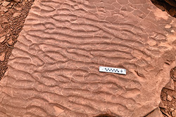
 This slab shows both ripple marks and mudcracks.
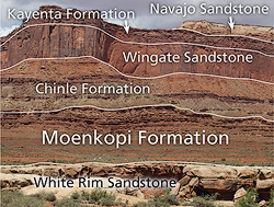
Southeastern Utah is a landscape of rock; that is, one dominated by bare rock surfaces, towering cliffs, rolling rock domes, and steep slopes. Unlike mountains in wetter climates like the Appalachians of the east or even the Rocky Mountains, any viewscape in canyon country is dominated by exposed rock.
The rock layers (formations to geologists) that generally get the most attention are those that make up the region’s cliffs, arches, and rock domes: the Wingate Sandstone cliffs above Moab, the natural arches and windows in the Entrada Sandstone in Arches National Park, and the Navajo Sandstone of the Slickrock Bike Trail and Hells Backbone 4WD Road.
The Moenkopi Formation is one of the layers that can get easily overlooked, particularly compared to the more charismatic cliff-formers in the region. But the Moenkopi deserves appreciation because it contains features that tell interesting stories about how it was deposited and makes some pretty spectacular landforms on its own when circumstances are right. The Moenkopi is a beautiful deep red color and can sometimes form fantastical hoodoos, even though it is made of thin beds of siltstone and sandstone.
The Moenkopi was deposited about 250 million years ago during the Triassic Period. (The Triassic is the early part of the Mesozoic—the Age of Reptiles—before dinosaurs became dominant.) Geologists infer that the Moenkopi was deposited mostly in tidal flats and river deltas, with some periods of marine
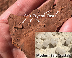 Salt crystals have a cubic shape and left imprints in the mud. Although the salt crystals were later dissolved, their casts reveal that they were once present.
conditions due to a slight rise in sea level, based on its sedimentary structures. Sedimentary structures are features formed during deposition thereby providing information on the conditions and environment at the time that the sediment was accumulating.
Abundant sedimentary structures tell the Moenkopi’s story. Ripple marks are by far the most common structures in Moenkopi beds and provide information on the ancient water currents. Many of the ones in the Moenkopi indicate a significant sediment load and tidal currents, while others show sediment transport under fluvial (river) conditions.
The presence of mudcracks show that sometimes the Moenkopi muds dried up, shrunk, and contracted. Salt crystal casts and nodules of gypsum (both evaporite minerals) in the upper part of
the Moenkopi show deposition on saline mudflats.
Perhaps the most interesting and unique features in the Moenkopi are subaqueous fossil tracks, informally known as swim smears, made by swimming or floating tetrapods (four-footed vertebrate animals) in a river delta. These traces consist of parallel scrapes made by the animals’ digits or toes as they swiped across the bottom in shallow water.
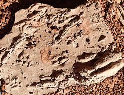 Casts of swim smears. Most of the Moenkopi swim smears appear as parallel grooves.
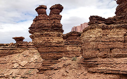 An usual hoodoo in the Moenkopi Formation in Canyonlands National Park.
 The Moenkopi Formation exposed in Canyonlands National Park.
The swim smears in the Moenkopi are particularly notable for several reasons. One, body fossils (e.g., bones) of vertebrates are essentially unknown from this layer, making tracks (both terrestrial and subaqueous) the only record of vertebrate life then. Two, they reveal somewhat unusual conditions in substrate of the river delta; that is, it was firm enough record fine details in the traces and so stable enough so that the traces didn’t get destroyed by water currents or organisms burrowing in the mud. Also interesting is the fact that the actual grooves that the animals made in the sediment themselves were never preserved; only the casts formed as sand infilled the grooves. The result is that these fossils are always found on the underside of Moenkopi beds.
 Dark red Moenkopi Formation exposed along the Scenic Drive in Capitol Reef National Park.
The best places to enjoy the Moenkopi Formation are in Canyonlands and Capitol Reef National Parks. In Canyonlands, the Moenkopi Formation sits directly on top of the White Rim Sandstone where the dramatic change in color make the two layers easily distinguishable. At Capitol Reef, park visitors spend a lot of time in the Moenkopi Formation, particularly near the Visitor Center and along the Scenic Drive.
Although the Moenkopi Formation is fairly prominent in some areas, it is less so in the immediate vicinity of Moab where the layer is quite thin and sits directly on top of another red layer of nearly the same hue. Because of this, the desire to fully experience the Moenkopi may provide people with additional motivation to explore the desert far beyond Moab.
|

 A self-described “rock nerd,” Allyson Mathis is a geologist, informal geoscience educator and science writer living in Moab.