Tourists and locals alike focus on the geologic features all around Moab that they see—the arches, the canyons, the soaring red cliffs and rock spires—versus what is beneath the Earth’s surface. But one of the most important factors responsible for the scenic and spectacular landscape of southeastern Utah is only present in the subsurface. It is a type of rock that has unusual characteristics compared to other sedimentary rock types, but one that is very familiar to us all: salt (sodium chloride).
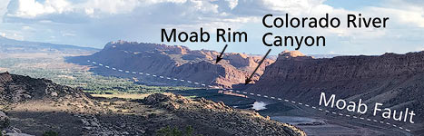 |
| View of Moab Valley showing the Moab Rim, the approximate trace of the Moab Fault, and the Colorado River crossing it. Spanish Valley is the southeastern extension of Moab Valley. |
Overall, there are four aspects of the geology of southeastern Utah that are most critical to the development of a land so stunningly beautiful that it hosts two national parks, two state parks, and Bears Ears National Monument, plus plenty of other picturesque public lands.
A thick sequence of sedimentary rocks that include many massive sandstone layers. These sandstones are resistant to erosion and they form the area’s many cliffs and rock domes.
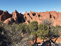 |
| Rock fins in Devils Garden in Arches National Park. Devils Garden is on the north flank of the Salt Valley anticline, where folding caused the sandstone layers to undergo brittle fracture. Water that seeped into the fractures (joints) caused them to preferentially weather and erode, leaving fins between them. |
The semi-arid climate which means that bedrock is exposed at the surface versus being covered by vegetation and soil.
Major rivers (the Colorado and Green) and their tributaries incising into a landscape with an overall high elevation.
Thick layers of salt in the Paradox Formation, which is present underground throughout the Moab area. The Paradox Formation was deposited in a hypersaline sea, which caused salt to precipitate. Unlike most other rock types, salt can move plastically under pressure, somewhat like Silly Putty. It is less dense than other rock types, so it usually flows up towards the surface. Salt also dissolves readily in water, unlike almost every other type of rock. (This last characteristic is why salt is never at the surface near Moab. The climate here is simply too wet for that.)
Salt tectonics is the term for the deformation of rock layers caused by flowing salt. In particular, three areas near Moab show the influence of salt tectonics on the landscape of canyon country. Two of these areas—the Moab-Spanish Valley and Salt Valley in Arches National Park—are similar to one another. The third, an area known as the Grabens in Canyonlands National Park, is a series of shallow parallel basins adjacent to Cataract Canyon.
Moab-Spanish Valley and Salt Valley are part of a series of northwest trending salt anticlines found in this part of southeastern Utah and western Colorado. An anticline is any fold in rock layers where they are warped upwards. A salt anticline is such a fold formed by upward bulging caused by flowing salt.
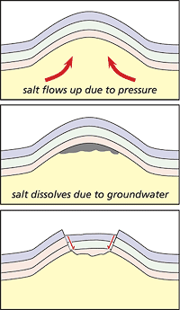 |
| Simplified diagram showing the evolution of a salt anticline. (Note, there is not an actual subterrain void due to salt dissolution as suggested in the middle diagram, which is shown for illustrative purposes only.). |
A salt anticline typically has topographic depression that looks like a valley along its axis. Instead of being carved by a river or stream, these depressions are actually the result of movement along faults. Salt dissolution by shallow groundwater causes the core of these anticlines to lose its underlying support, yielding its collapse.
The presence of Salt and Cache valleys in Arches National Park is one of the most important reasons why there is a multitude of natural arches in the park as the upwarping on the edges of the salt anticlines formed sets of parallel fractures (known as joints). Weathering and erosion along these joints led to the creation of parallel rock fins (elongated rock ridges with nearly vertical sides), which in turn are excellent sites for arch formation.
Other salt anticlines in the region include Castle Valley north of Moab, Lisbon Valley to the east, and Paradox Valley in Colorado.
The Grabens is the Needles District of Canyonlands is an unusual area of shallow troughs that run side by side. Each graben is a down-dropped block formed by faulting, and is up to approximately 300 feet deep. The Grabens were also formed because of flowing salt. In this case, salt movement was initiated after the incision of Cataract Canyon, just to the west. The existence of Cataract Canyon formed an area of low pressure so that the salt began moving laterally to it. As it moved, it carried the overlying rock layers with it, causing some to drop down in order to accommodate the stretching of the land.
The salt anticlines in southeastern Utah are older and more complex features than the Grabens. Salt began moving in the salt anticlines while many of the rock layers (formations to geologists) above it were still being deposited. Much of the movement occurred during the Mesozoic Period (252 to 66 million years ago), with additional movement and salt dissolution during the last 10 million years. The Grabens, on the other hand, are very young geologic features, having been formed during the last half million years or so.
The story of salt flowage and dissolution in southeastern Utah is a good example of how understanding of a natural phenomenon, whether it is a natural arch or a “valley” where the river flows perpendicularly across it like here in Moab, is found at a deeper level than what is at the surface..
|
 A self-described “rock nerd,” Allyson Mathis is a geologist, informal geoscience educator and science writer living in Moab.