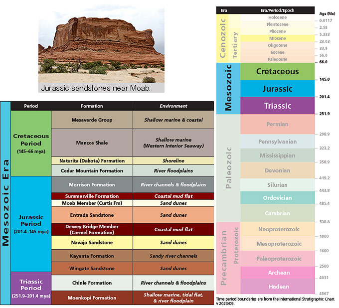
The Mesozoic is one of the major eras of geologic time. It contains the time span from 251.9 to 66.0 million years ago, and is commonly known as the Age of Reptiles or alternatively the Age of Dinosaurs. During the Mesozoic, these groups of animals dominated life on land, and, in the case of reptiles, were the top predators of the seas. It is also the time interval in which most of the rock layers (formations to geologists) exposed near Moab were deposited, so it has special significance in this area’s geologic story.
The Mesozoic is one of three eras of the Phanerozoic Eon of the geologic time scale. The Phanerozoic only makes up about 12% of geologic time, with the bulk of the history of the planet assigned to the Precambrian. The Phanerozoic (“visible life”) began with the sudden appearance of abundant fossils and rapid diversification of life. Life had existed on Earth for approximately 3.5 billion years prior to the development of animals with hard parts like trilobites at the dawn of the Cambrian explosion.
The Phanerozoic contains three eras: Paleozoic (“ancient life”), Mesozoic (“middle life”), and Cenozoic (“recent life”). During the Paleozoic, fishes, amphibians, and reptiles evolved, plants and animals colonized land, and the oceans contained diverse invertebrate life mostly different than today.
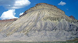 |
| The upper part of the Mancos Shale and the lower portion of the Mesaverde Group near Grand Junction. Photo by James St. John. |
Major extinction events mark the boundaries between eras. The extinction event that marked the demise of the dinosaurs, known as the K-T boundary (Cretaceous-Tertiary), is well-known, but the extinction event at the start of the Mesozoic, the Great Dying, was even bigger. More than 80% of marine species and 70% of vertebrate species living on land died off at the end of the Paleozoic.
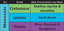
The Mesozoic consists of three periods, each with distinctive fossils. Non-dinosaurian reptiles like phytosaurs and relatives of modern crocodiles were prevalent during the Triassic and the evolution of the first dinosaurs and the first mammals occurred. By the Jurassic Period, dinosaurs had diversified greatly. The Jurassic Morrison Formation, exposed near Moab and elsewhere, contains an abundance of dinosaurs including Allosaurus, Apatosaurus, and Stegosaurus. The Cretaceous saw new dinosaur groups evolve, including the duckbilled hadrosaurs, Triceratops, and Utahraptor, which was first found in the Cedar Mountain Formation near Moab.
-sharpened.jpg) |
| The upper part of the Mancos Shale and the lower portion of the Mesaverde Group near Grand Junction. Photo by James St. John. |
Rock layers from all three Mesozoic periods are found near Moab. There are two Triassic layers, plus the Wingate Sandstone which is late Triassic to early Jurassic. Eight of Moab’s layers were deposited during the Jurassic, and four during the Cretaceous, although a thicker sequences of Cretaceous rocks are found north of Moab in the Book Cliffs on the other side of I-70.
As it turns out, rock layers of each period near Moab generally share some characteristics with each other. Cretaceous rocks in southeastern Utah tend to be rather drably colored and contain thick shale and mudstone deposits and shoreline deposits of the Western Interior Seaway, which covered the central part of North America then. The oldest Cretaceous layer in this region, the Cedar Mountain Formation, was deposited on river floodplains prior to the sea level rise that flooded the continent.
Jurassic sandstones that are eolian (wind deposited) in origin dominate the landscape near Moab, including in Arches and Canyonlands national parks. The Wingate, Navajo, Entrada, and Curtis (Moab Member) sand dune fields were near Moab during the Jurassic, although they varied greatly in size. The Navajo erg (sand sea) covered most of Utah and parts of adjacent states, but the Entrada and Moab Member dunefields were local. Other Jurassic layers were deposited in different environments: sandy rivers ( Kayenta Formation), coastal mud flats (Carmel Formation Dewey Bridge Member and Summerville Formation), and river channels and their floodplains (Morrison Formation).
Jurassic rocks exposed near Moab also have a predominant hue—red from small amounts of iron oxide present in the rocks, commonly coating the sand grains.
The two Triassic layers, the Moenkopi and Chinle formations, are a bit different from each other, although they both consist mostly of thin beds of mudstone, siltstone, and sandstone. A significant period of missing time (an uncomformity) separates the two, with the Moenkopi being deposited on a nearly flat landscape of tidal flats, mudflats, floodplains, and river deltas. The Chinle Formation was deposited more than 10 million years later by rivers and on floodplains.
Moab today is part of the high desert of the Colorado Plateau where people travel from all around the world to marvel at the the spectacular scenery of cliffs and canyons, and natural arches and buttes formed through erosion. On the other hand, if it were possible to travel back in time to visit Moab in the Mesozoic, the environments would be substantially different than what is here today, and there would be a very good chance to see dinosaurs.
|
 A self-described “rock nerd,” Allyson Mathis is a geologist, informal geoscience educator and science writer living in Moab.