 |
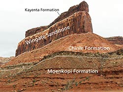
| The Moenkopi Formation and Chinle Formation are Triassic in age. The Wingate Sandstone was deposited from the late Triassic into the Jurassic. The Kayenta Formation that makes up the upper part of the cliff is Jurassic in age. |
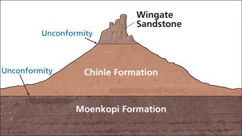
The most significant aspects of the geologic story of the Triassic Period of the Moab area may not be those contained in the Triassic rock layers (formations to geologists) themselves, although, to be clear, these rock layers are iconic. Triassic rocks found near Moab consist of the triptych of the slope-forming Moenkopi and Chinle formations capped by the sheer cliffs of the Wingate Sandstone. This cliff-and-slope combination is responsible for miles and miles of redrock cliffs throughout southeastern Utah. They make up the canyon rims above the Colorado River and above Moab, at Dead Horse Point State Park, along Indian Creek, and in Capitol Reef National Park, among other places.
The Triassic Period occurred between 252 and 201 million years ago, in the early part of the Mesozoic Era at the time of the rise of the dinosaurs. The Triassic was also the interval that the supercontinent Pangaea existed, although North America and Europe started to separate from one another then with the opening of the Atlantic Ocean then.
 |
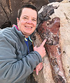
| The Triassic section in Indian Creek. |
Here in Utah, a major tectonic (e.g., relating to large-scale processes of Earth’s crust) change occurred during the Triassic, with the change occurring between the deposition of the Moenkopi Formation and that of the Chinle Formation.
The Moenkopi Formation is the oldest Triassic rock unit found in southeastern Utah. It was deposited in the early Triassic, about 250 million years ago, in shallow marine, tidal flat, and river floodplain environments. The climate was hot and arid, and thinly bedded siltstone and sandstone layers with abundant ripple marks, usually of a deep maroon red color, were deposited.
The Chinle Formation was deposited between about 230 and 205 million years ago, in the late Triassic. The Chinle’s sandstones and mudstones were deposited in a monsoonal climate in the channels and floodplains of river systems flowing from the southeast towards the northwest. The unit features candy-striped mudstones that were formed in ancient soil horizons (paleosols). The Chinle contains important vertebrate fossils of dinosaurs and other reptiles, and abundant petrified wood. It was one of the principle layers mined for uranium-deposits during the uranium boom. Bentonite (a type of swelling clay formed from altered volcanic ash) is present in many of its mudstone layers, making roads through the Chinle Formation sometimes impassible when wet.
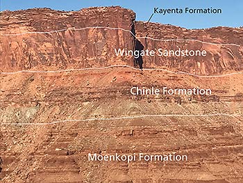 The Wingate Sandstone is strikingly different from the Moenkopi and Chinle formations below it. The Wingate is a hard sandstone that forms vertical cliffs. The depositional environment of the Wingate Sandstone was also drastically distinct from the two layers beneath it. Instead of mudflats, river channels, or floodplains, the Wingate Sandstone is eolian in origin, meaning it was deposited in a vast sand dune system in a desert environment.
The Wingate Sandstone was deposited between about 202 and 195 million years ago. Only the lower part of the Wingate Sandstone was deposited near the end of the Triassic; most of the formation was deposited in the early Jurassic.
Separating the three Triassic layers found in southeastern Utah are unconformities, or periods of missing time when either erosion took place and/or during which sediments were not deposited. An unconformity can represent any length of time, and geologists identify them based on ancient weathering and erosional surfaces at the contact (boundary) between successive rock layers and/or by gaps in time identified via fossils. The unconformity at the base of the Wingate Sandstone is relatively short as it is a period of a few million years at most, but the one beneath the Chinle is much longer (about 20 million years or so).
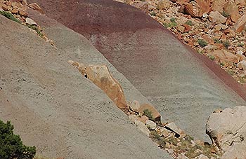 |
| Mudstone containing bentonite in the Chinle Formation in Capitol Reef National Park. Photo by James St. John |
The presence of bentonite in the Chinle Formation and its absence in the Moenkopi provides evidence that at least some of the events must have happened during the period of missing time represented by the unconformity. Bentonite only forms in sediments where volcanic ash has fallen, which means that volcanoes must have erupted during Chinle time. The volcanic eruptions that produce widespread volcanic ash deposits mostly occur above subduction zones, which in turn happen in collisional tectonic environments. The volcanic arcs where the eruptions occurred were to the west of southeastern Utah, and winds carried the volcanic ash into the Chinle basin.
Therefore, the Moenkopi-Chinle unconformity reflects a change from depositional environments in Utah from one in a passive margin to that in an active margin (to use geologic jargon). An active margin is at the edge of a continent that is actively colliding with an oceanic plate, like at the modern Oregon and Washington coasts. A passive margin is a quiet edge of a continent, like the east coast of the United States.
This switch from a passive to an active margin marked a long-lasting change in the geologic history of Utah. Utah has been impacted by active tectonics to the west since the middle of the Triassic. Mountain-building events in western Utah, Nevada, and California impacted the deposition of the layers younger than the Moenkopi, and tectonic events led to uplift of the Colorado Plateau and subsequent erosion that carved canyon country.
|
 A self-described “rock nerd,” Allyson Mathis is a geologist, informal geoscience educator and science writer living in Moab.