 Each rock layer found near Moab has its own personality. Rocks aren’t sentient beings (of course), but each layer has their own unique characteristics that set them apart from other rock layers and are what we notice as we explore canyon country. To provide a few examples, the Entrada Sandstone makes the reddish-orange cliffs and fins in Arches National Park, the Mancos Shale forms gray badlands and the barren slopes of the Book Cliffs, and the Morrison Formation includes soft mudstones that erode to candy-striped barren slopes. Each rock layer found near Moab has its own personality. Rocks aren’t sentient beings (of course), but each layer has their own unique characteristics that set them apart from other rock layers and are what we notice as we explore canyon country. To provide a few examples, the Entrada Sandstone makes the reddish-orange cliffs and fins in Arches National Park, the Mancos Shale forms gray badlands and the barren slopes of the Book Cliffs, and the Morrison Formation includes soft mudstones that erode to candy-striped barren slopes.
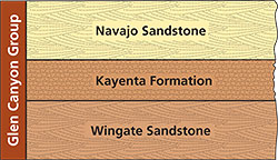
Among the most prominent rock layers near Moab are three sandstone units: the Wingate Sandstone, the Kayenta Formation, and the Navajo Sandstone. Each has been defined as a formation in geology’s formal lithostratigraphic ranking system for naming sedimentary rock.
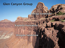 |
| The Glen Canyon Group at the Island in the Sky in Canyonlands National Park where the three units make a nearly continuous cliff. |
In informal parlance, a formation is called a rock layer. Specifically, a formation is body of rock with identifiable characteristics and that can be depicted on a map showing where it is exposed at the surface. Sedimentary rock formations generally consist of a certain type (or types) of sediments deposited in specific environments at particular intervals of geologic time.
Most often, rock layers are completely independent of one another. Each one may record a different environment in which sediments were deposited; marine conditions in one, with river floodplains in another, and perhaps a coal swamp in yet another. Significant periods of time may pass when erosion took place before the deposition of the subsequent layer.
So while rock layers are individuals, sometimes they are also part of a larger grouping of rock layers—a geologic “family” if you will. These geologic “families” occur where the rock units share something in common. The Wingate Sandstone, Kayenta Formation, and Navajo Sandstone are three such layers. They are all part of the Glen Canyon Group, with group being the next higher stratigraphic rank above formation.
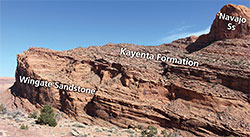 |
| The Glen Canyon Group on the Moab Rim where the Kayenta Formation provides a break in slope between the cliff-forming Wingate and Navajo Sandstones. |
The Glen Canyon Group was named for a sequence of rocks exposured in Glen Canyon, and the individual formations were described from locations on the Navajo Nation. Together, the geologic history of the Wingate, Kayenta, and Navajo is that of a three part story of sand dunes, rivers, and sand dunes again, with all three environments dominated by the deposition sand-sized sediment. Deposition was continuous or nearly so (e.g., with only a short break) during this time interval so that the three layers make up a coherent geologic story where they are all a part of a single geologic “family” tree.
The Glen Canyon Group’s geologic history began with the deposition of the Wingate Sandstone in an erg (e.g., a massive dunefield or sand sea). The Wingate erg covered all of Utah except for the far northwest and northeast corners and also extended in the Four Corners region in adjacent states. A short time later, major river systems flowing to the west from the Ancestral Rocky Mountains in western Colorado were established. These sandy river beds are recorded in the Kayenta Formation with its hallmark thin sandstone layers stacked one on top of another. Kayenta time gradually came to the end as the environment became more arid again leading to another erg, this one even larger than the Wingate one. The Navajo Sandstone was deposited in part of the largest sand dune system in North America’s history with its entire aerial extent being as great as 850,000 square miles.
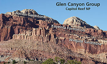 |
| The Glen Canyon Group in Capitol Reef National Park. |
The Glen Canyon Group was deposited during the late Triassic and the Jurassic periods in the era commonly known as the age of dinosaurs, between about 200 and 185 million years ago. Dinosaur fossils, both bone fossils and tracks, have been found in its layers.
The sandstones that make up the Glen Canyon Group are very resistant to erosion, so today, the Glen Canyon Group makes cliffs—miles and miles and more miles of vertical cliffs that dominate the landscape.
The Wingate and Kayenta usually team up to form maroon-brown-colored vertical cliffs. The Kayenta makes up about the top half of these sheer cliffs, although the contact (boundary) with the Wingate can be hard to see. It is where the Kayenta’s thin horizontal sandstone layers visible. The Navajo Sandstone sometimes makes a lighter-colored uppermost portion of a nearly continuous cliff line, but more often it makes rounded rock domes that sit a little ways back from the cliff edge. In other areas, such as along the Moab Rim Trail, the Kayenta provides a break in slope between Wingate and Navajo cliffs.
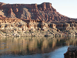 |
| The Moenave Formation makes up the top of the cliffs above Lees Ferry. It looks superficially like the Wingate,
but contains more thin layers and was largely deposited
by rivers. |
In southeastern Utah, the Glen Canyon Group always consists of these three layers. But at Lees Ferry at the start of Grand Canyon, and in southwest Utah in and around Zion National Park, the Wingate Sandstone is not present. Another layer, the Moenave Formation, makes the base of the group in these areas. The Moenave was largely deposited in fluvial (river) system that flowed from northern Arizona towards Nevada.
Considering the relationships within geologic “families” can deepen understanding of the stories that canyon country’s rock layers tell. Some layers stand independently alone as individuals, but others like the Wingate, Kayenta, and Navajo form a group where the whole story is greater than the sum of its parts.
|
 A self-described “rock nerd,” Allyson Mathis is a geologist, informal geoscience educator and science writer living in Moab.