 |
| Curtis Stratigraphy |
Sedimentary rock layers (formations to geologists) are records of particular times and places in geologic history. They are made of a specific rock type (or types) that were deposited in certain environments such as sand dunes, tidal flats, or in rivers and their floodplains. They are deposited in distinct geographic areas (such as southeastern Utah) during certain intervals of Earth’s history as revealed by fossils and other evidence that they contain. As a result of these parameters, each rock layer tells its own story of what, where, when, and how: what they are made of, and where when, and how they were deposited.
Some rock layers are pretty much the same from place to place; e.g., they tell a rather uniform story throughout the entire geographic area in which they were deposited. For example, the Navajo Sandstone makes white-to-orange soaring cliffs and rounded rock domes pretty much wherever it is found, whether in Sand Flats above Moab, to the south in Glen Canyon, or almost completely on the far side of Utah in Zion National Park. The vast sand dune system that the Navajo Sandstone was deposited in didn’t change much from place to place, although it was thinner to near its edge.
 |
| Goblin Valley State Park |
Other rock layers vary a great deal over relatively short distances. These rock layers were deposited in more complex environments or in areas where one environment transitioned into another one. This type of change is that of a traverse from open ocean water to tidal zone to coastline and then to an inland area. Sediments are deposited at the same time in each of these environments, but the variations in the depositional environments results in differences in the type of sediments deposited (sand, silt, clay, or lime).
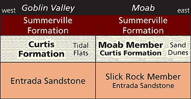
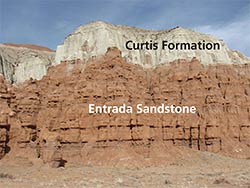
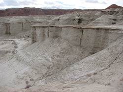
The Curtis Formation is a good example of a layer that changes dramatically over a relatively short distance. The Curtis Formation was deposited in the Moab area and to west and north towards the San Rafael Swell region during the Jurassic, approximately 157 million years ago. The Curtis sits on top of the Entrada Sandstone, which is the iconic layer in Arches National Park, containing the bulk of its natural arches, and makes up the goblins in Goblin Valley State Park.
Goblin Valley is approximately 60 miles due west of Moab on the east side of the San Rafael Swell. But the Curtis Formation found near Moab and the Curtis Formation present at Goblin Valley are very different. Near Moab, the Curtis was deposited in a sand dune environment. Near Goblin Valley, it was deposited in tidal flats on the margins of an interior seaway that extended down central Utah from the north.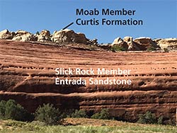
Geologists use the term facies to describe a part of a rock layer that is distinguished from other parts of that same layer based on different rock types (or fossil content). Unique facies are often broken out as distinct members (subdivisions) of formations. They are found in only a portion of the geographic area where the formation occurs.
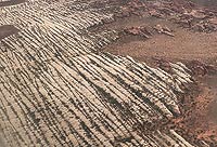
The Moab Member (or Tongue) is a facies of the Curtis Formation. The Moab Member represents an eolian facies of the Curtis Formation, meaning that it was deposited as blowing sand in dunes in an area east of the seaway. The rest of the Curtis Formation was deposited under marine conditions as shown by the presence of tidal ripples, marine fossils, and the clay mineral glauconite which give the unit a slightly green tint. Glauconite is always an indicator of marine conditions since it exclusively forms in them.
The Moab erg covered a relatively small area basically centered on where Moab is now (which is how it got its name. Rock layers and members are named for places where they are first described). Originally, the Moab Member was considered a part of the underlying Entrada Sandstone. Both are eolian sandstones with large sweeping crossbeds formed from dune movements. However, geologists later traced the Moab sandstones west to where they clearly correlate with the Curtis Formation. In 2000, geologists formally revised the stratigraphy to designate the Moab Member a part of the Curtis Formation.
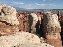
The Moab Member is up to 180 feet thick in Arches National Park and thins to a feather edge near the Green River. The hard Moab Member is exposed at the surface in large areas west of Arches, including near the Brands Mountain Bike area and Klondike Bluffs. The Dinosaur Stomping Ground tracks are in the Moab Member near its upper contact.
Today, a trip from Moab to Goblin Valley entails only relatively subtle differences in the environment as both are in Utah’s high desert. During the Jurassic, that same traverse would be a journey from the center of a sand dunefield, to its very margin, and then to a wide area of tidal flats on the edge of a shallow sea. The scenery is arguably better in Utah today than during Curtis time. But back in the Jurassic, Utah contained dunes, tidal flats, and a shallow sea. And there were dinosaurs.
 |
 |
 |
| The Moab Member of the Curtis Sandstone above the Slickrock Member of the Entrada Sandstone at Klondike Bluffs in Arches National Park |
The Curtis Formation in Goblin Valley State Park |
An aerial view of the Moab Member |
|
 A self-described “rock nerd,” Allyson Mathis is a geologist, informal geoscience educator and science writer living in Moab.